Category:New Hythe
Jump to navigation
Jump to search
English: New Hythe is a village in mid-Kent, England on the banks of the River Medway approximately 5 miles northwest of the county town of Maidstone. It derives its name from the Old English word Hythe, meaning haven or landing place.
village in the United Kingdom  | |||||
| Upload media | |||||
| Instance of | |||||
|---|---|---|---|---|---|
| Location | Ditton, Tonbridge and Malling, Kent, South East England, England | ||||
 | |||||
Media in category "New Hythe"
The following 23 files are in this category, out of 23 total.
-
 Avery Drive, New Hythe - geograph.org.uk - 1585295.jpg 640 × 480; 61 KB
-
 Bricklayer's Arms, New Hythe - geograph.org.uk - 1585234.jpg 640 × 480; 64 KB
-

-

-

-
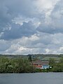
 Leybourne Lake - geograph.org.uk - 21567.jpg 640 × 480; 74 KB
-
 Leybourne Lakes - geograph.org.uk - 258.jpg 640 × 480; 52 KB
-
 Leybourne Lakes Country Park - geograph.org.uk - 665697.jpg 640 × 400; 89 KB
-
 Leybourne Lakes, May 2021 01.jpg 3,888 × 5,184; 3.65 MB
-
 Leybourne Lakes, May 2021 02.jpg 3,888 × 5,184; 4.66 MB
-

-

-
 New Housing on New Hythe Lane - geograph.org.uk - 1513184.jpg 640 × 427; 78 KB
-
 New Hythe Lake - geograph.org.uk - 21520.jpg 640 × 480; 66 KB
-
 New Hythe Lane Bridge - geograph.org.uk - 1097357.jpg 640 × 481; 72 KB
-
 New Hythe Lane over M20 - geograph.org.uk - 1097410.jpg 481 × 640; 77 KB
-
 Offices on New Hythe Road - geograph.org.uk - 1513203.jpg 640 × 427; 71 KB
-
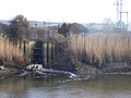 Outfall from Sewage Works - geograph.org.uk - 1097322.jpg 640 × 481; 80 KB
-
 Private Fishing Club Lake - geograph.org.uk - 1084306.jpg 640 × 481; 123 KB
-
 Railway line at New Hythe - geograph.org.uk - 1542448.jpg 640 × 480; 71 KB
-
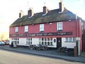 The Bricklayers Arms, New Hythe - geograph.org.uk - 1097380.jpg 640 × 481; 75 KB
-
 The Lakes estate - geograph.org.uk - 491595.jpg 640 × 480; 51 KB
-
 West Mead, New Hythe - geograph.org.uk - 1542455.jpg 640 × 480; 68 KB


