Category:Nemelaer, Haaren
Jump to navigation
Jump to search
| Object location | | View all coordinates using: OpenStreetMap |
|---|
 | |||||
| Upload media | |||||
| Instance of | |||||
|---|---|---|---|---|---|
| Part of | |||||
| Location | Haaren, Oisterwijk, North Brabant, Netherlands | ||||
| Street address |
| ||||
| Located on street |
| ||||
| Heritage designation |
| ||||
 | |||||
|
This is a category about rijksmonumentcomplex number 520096
|
Kasteel:
|
This is a category about rijksmonument number 520097
|
Parkaanleg:
|
This is a category about rijksmonument number 520098
|
Bijgebouw:
|
This is a category about rijksmonument number 520100
|
Inrijhek:
|
This is a category about rijksmonument number 520101
|
Dam met hek:
|
This is a category about rijksmonument number 520102
|
Sculpturen:
|
This is a category about rijksmonument number 520103
|
| Address |
|
Media in category "Nemelaer, Haaren"
The following 56 files are in this category, out of 56 total.
-
 1e verdieping, linker achterkamer - Haaren - 20095665 - RCE.jpg 1,200 × 954; 298 KB
-
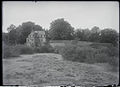
 Achterzijde, reproductie uit buiten - Haaren - 20095642 - RCE.jpg 1,200 × 803; 248 KB
-
 Begane grond, linker achterkamer - Haaren - 20095662 - RCE.jpg 1,200 × 952; 272 KB
-
 Begane grond, linker achterkamer - Haaren - 20095663 - RCE.jpg 1,200 × 955; 244 KB
-
 Begane grond, linker achterkamer - Haaren - 20095664 - RCE.jpg 1,200 × 960; 242 KB
-
 Begane grond, linker voorkamer - Haaren - 20095659 - RCE.jpg 953 × 1,200; 299 KB
-
 Begane grond, linker voorkamer - Haaren - 20095660 - RCE.jpg 1,200 × 954; 251 KB
-
 Begane grond, linker voorkamer - Haaren - 20095661 - RCE.jpg 948 × 1,200; 261 KB
-
 Begane grond, rechter achterkamer - Haaren - 20095658 - RCE.jpg 967 × 1,200; 276 KB
-
 Begane grond, rechter voorkamer - Haaren - 20095656 - RCE.jpg 955 × 1,200; 207 KB
-
 Begane grond, rechter voorkamer - Haaren - 20095657 - RCE.jpg 1,200 × 958; 207 KB
-

-
 Gezicht naar achtergevel - Haaren - 20095655 - RCE.jpg 960 × 1,200; 237 KB
-
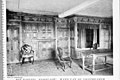
 Hal interieur - Haaren - 20095649 - RCE.jpg 953 × 1,200; 208 KB
-
 Hal interieur - Haaren - 20095650 - RCE.jpg 947 × 1,200; 236 KB
-
 Informatiebord Kasteel Nemerlaer DSCF5801.jpg 2,816 × 1,864; 2.41 MB
-
 Informatiebord Kasteel Nemerlaer DSCF5816.jpg 2,816 × 1,864; 2.43 MB
-
 Ingang, reproductie uit buiten - Haaren - 20095643 - RCE.jpg 1,200 × 805; 257 KB
-
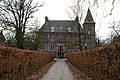
 Kasteel Nemelaer - panoramio.jpg 4,592 × 2,576; 4.72 MB
-
 Kasteel Nemerlaer 1.JPG 4,000 × 3,000; 4.87 MB
-
 Kasteel Nemerlaer 2.JPG 4,000 × 3,000; 4.93 MB
-
 Kasteel Nemerlaer 3.JPG 4,000 × 3,000; 4.7 MB
-
 Kasteel Nemerlaer 4.JPG 4,000 × 3,000; 4.97 MB
-
 Kasteel Nemerlaer 5.JPG 4,000 × 3,000; 4.75 MB
-
 Kasteel Nemerlaer 6.JPG 4,000 × 3,000; 4.97 MB
-
 Kasteel Nemerlaer 7.JPG 4,000 × 3,000; 5.12 MB
-
 Kasteel Nemerlaer DSCF5802.jpg 2,816 × 1,864; 2.51 MB
-
 Kasteel Nemerlaer DSCF5803.jpg 2,816 × 1,864; 2.52 MB
-
 Kasteel Nemerlaer DSCF5813.jpg 2,816 × 1,864; 2.65 MB
-
 Kasteel Nemerlaer DSCF5814.jpg 1,864 × 2,816; 2.49 MB
-
 Kasteel Nemerlaer DSCF5815.jpg 2,816 × 1,864; 2.64 MB
-
 KasteelNemerlaer.jpg 302 × 249; 81 KB
-
 Nemerlaer donker.JPG 2,938 × 1,890; 1.68 MB
-
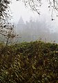 Nemerlaer mist.jpg 1,476 × 2,094; 509 KB
-
 Nemerlaer-Haaren (7).JPG 2,000 × 3,008; 2.05 MB
-
 Nemerlaer.jpg 1,000 × 664; 201 KB
-
 Noord-zijde exterieur - Haaren - 20095646 - RCE.jpg 1,200 × 958; 259 KB
-
 Noord-zijde exterieur - Haaren - 20095647 - RCE.jpg 1,200 × 953; 334 KB
-
-

-

-
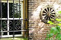
 Rococo schoorsteen, reproductie uit buiten - Haaren - 20095640 - RCE.jpg 803 × 1,200; 248 KB
-
 Souterrain interieur - Haaren - 20095651 - RCE.jpg 960 × 1,200; 299 KB
-
 Souterrain interieur - Haaren - 20095652 - RCE.jpg 1,200 × 956; 306 KB
-
 Souterrain interieur - Haaren - 20095653 - RCE.jpg 1,200 × 960; 307 KB
-
 Souterrain interieur - Haaren - 20095654 - RCE.jpg 1,200 × 944; 279 KB
-
 T.T Kasteel Nemerlaer Detail Smeedwerk (2).JPG 3,072 × 2,048; 3.2 MB
-
 T.T Kasteel Nemerlaer Detail Smeedwerk.JPG 2,048 × 3,072; 1.28 MB
-
 T.T Kasteel Nemerlaer Detail Venster.JPG 3,072 × 2,048; 1.33 MB
-
 T.T Kasteel Nemerlaer.JPG 3,072 × 2,048; 2.22 MB
-
 Voorgevel, reproductie uit buiten - Haaren - 20095641 - RCE.jpg 1,200 × 803; 244 KB
-
-
 Wandbetimmering, reproductie uit buiten - Haaren - 20095639 - RCE.jpg 1,200 × 805; 217 KB
-
 West-gevel - Haaren - 20095648 - RCE.jpg 965 × 1,200; 349 KB
-
 Zuid-gevel - Haaren - 20095644 - RCE.jpg 1,200 × 946; 395 KB
-
 Zuid-gevel - Haaren - 20095645 - RCE.jpg 1,200 × 958; 323 KB


.JPG)


.JPG)


