Category:Neils Red Covered Bridge
Jump to navigation
Jump to search
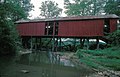
Red or Neils Covered Bridge was a covered bridge over Whiteley Creek in Green Township, Greene County, Pennsylvania.
|
This is a category about a place or building that is listed on the National Register of Historic Places in the United States of America. Its reference number is 79003817. |
| Object location | | View all coordinates using: OpenStreetMap |
|---|
 | |||||
| Upload media | |||||
| Instance of | |||||
|---|---|---|---|---|---|
| Location | Greene Township, Greene County, Pennsylvania | ||||
| Heritage designation | |||||
| Dissolved, abolished or demolished date |
| ||||
 | |||||
Media in category "Neils Red Covered Bridge"
The following 2 files are in this category, out of 2 total.
-
 NEILS RED C.B., GREENE CO.jpg 5,211 × 3,475; 1.89 MB
-
 NEILS RED COVERED BRIDGE.jpg 5,352 × 3,451; 3.53 MB

Categories:
- National Register of Historic Places in Greene County, Pennsylvania
- Covered bridges on the National Register of Historic Places in Pennsylvania
- Bridges in Greene County, Pennsylvania
- Destroyed bridges in Pennsylvania
- Destroyed in the United States in 1990
- Bridges on the National Register of Historic Places in Pennsylvania
- 1900s bridges in Pennsylvania
- Bridges in the United States completed in 1900
- Built in Pennsylvania in 1900
- Burr truss
- Greene Township, Greene County, Pennsylvania