Category:Nederlands Hervormde Pastorie (Naaldwijk)
Jump to navigation
Jump to search
| Object location | | View all coordinates using: OpenStreetMap |
|---|
 | |||||
| Upload media | |||||
| Instance of |
| ||||
|---|---|---|---|---|---|
| Location | Naaldwijk, Naaldwijk | ||||
| Street address |
| ||||
| Located on street |
| ||||
| Heritage designation |
| ||||
 | |||||
|
This is a category about rijksmonument number 30169
|
| Address |
|
Media in category "Nederlands Hervormde Pastorie (Naaldwijk)"
The following 22 files are in this category, out of 22 total.
-
 Gevel - Naaldwijk - 20161584 - RCE.jpg 1,192 × 1,200; 525 KB
-
 Gevel - Naaldwijk - 20161585 - RCE.jpg 1,186 × 1,200; 444 KB
-
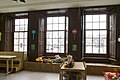
 Interieur - Naaldwijk - 20161588 - RCE.jpg 1,200 × 1,192; 334 KB
-
 Interieur trap - Naaldwijk - 20161587 - RCE.jpg 1,190 × 1,200; 365 KB
-

-

-
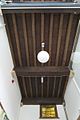
 Interieur, balkenplafond - Naaldwijk - 20412828 - RCE.jpg 798 × 1,200; 138 KB
-

-

-
-
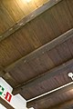
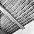
 Interieur, overzicht balkenplafond - Naaldwijk - 20412829 - RCE.jpg 798 × 1,200; 122 KB
-

-
-

-
 Naaldwijk kerk met Wilhelminaplein.JPG 800 × 600; 194 KB
-
 Voor- en zijgevel, hoekpand - Naaldwijk - 20161582 - RCE.jpg 1,200 × 950; 264 KB
-
 Voorgevel - Naaldwijk - 20161583 - RCE.jpg 1,188 × 1,200; 514 KB
-
 Voorgevel - Naaldwijk - 20161586 - RCE.jpg 1,192 × 1,200; 498 KB
-
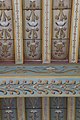
 Zolderbeschildering linker voorkamer - Naaldwijk - 20161592 - RCE.jpg 1,200 × 1,200; 312 KB
-
 Zolderbeschildering linker voorkamer. - Naaldwijk - 20161590 - RCE.jpg 1,188 × 1,200; 325 KB
-
 Zoldering beschildering linker voorkamer - Naaldwijk - 20161589 - RCE.jpg 1,192 × 1,200; 368 KB
-
 Zoldering, beschildering linker voorkamer - Naaldwijk - 20161591 - RCE.jpg 1,192 × 1,200; 306 KB


