Category:Nederlands Hervormde Kerk (Sint Pancras)
Jump to navigation
Jump to search
| Object location | | View all coordinates using: OpenStreetMap |
|---|
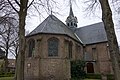
church building in Langedijk, Netherlands  | |||||
| Upload media | |||||
| Instance of | |||||
|---|---|---|---|---|---|
| Location | Sint Pancras, North Holland, Netherlands | ||||
| Street address |
| ||||
| Located on street |
| ||||
| Heritage designation |
| ||||
| Inception |
| ||||
 | |||||
Nederlands: Hervormde Kerk, Sint Pancras - anno 1525
|
This is a category about rijksmonument number 33664
|
| Address |
|
Media in category "Nederlands Hervormde Kerk (Sint Pancras)"
The following 8 files are in this category, out of 8 total.
-
 Exterieur - Sint Pancras - 20181522 - RCE.jpg 1,200 × 809; 186 KB
-
 Hervormde Kerk, Sint Pancras 01.jpg 5,472 × 3,648; 14.63 MB
-
 Hervormde Kerk, Sint Pancras 02.jpg 5,472 × 3,648; 14.62 MB
-
 Hervormde Kerk, Sint Pancras 03.jpg 5,472 × 3,648; 14.65 MB
-
 Hervormde Kerk, Sint Pancras 04.jpg 5,371 × 3,581; 15.35 MB
-
 Hervormde Kerk, Sint Pancras 05.jpg 5,472 × 3,648; 15.63 MB
-
 Hervormde Kerk, Sint Pancras 06.jpg 5,472 × 3,648; 15.58 MB
-
 Interieur, aanzicht orgel - Sint Pancras - 20370535 - RCE.jpg 853 × 1,200; 178 KB


