Category:Nederlands Hervormde Kerk (Biezelinge)
Jump to navigation
Jump to search
| Object location | | View all coordinates using: OpenStreetMap |
|---|
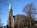
church building in Kapelle, Netherlands  | |||||
| Upload media | |||||
| Instance of | |||||
|---|---|---|---|---|---|
| Part of | |||||
| Location | Kapelle, Zeeland, Netherlands | ||||
| Street address |
| ||||
| Architect | |||||
| Heritage designation |
| ||||
| Inception |
| ||||
| Significant event |
| ||||
 | |||||
|
This is a category about rijksmonumentcomplex number 508047
|
Kerk
|
This is a category about rijksmonument number 508048
|
Graf
|
This is a category about rijksmonument number 508049
|
| Address |
|
Media in category "Nederlands Hervormde Kerk (Biezelinge)"
The following 4 files are in this category, out of 4 total.
-
 Biezelinge protestantse kerk.JPG 3,072 × 2,304; 3.08 MB
-
 Biezelinge, familiegraf RM508049 2012-05-17 16.41.JPG 4,416 × 3,312; 10.08 MB
-
 Overzicht - Biezelinge - 20034845 - RCE.jpg 1,190 × 1,200; 249 KB
-
 Overzicht zuidwestgevel met kerktoren - Biezelinge - 20352815 - RCE.jpg 947 × 1,200; 274 KB


