Category:Nederlands Hervormde Kerk, Sint Laurens
Jump to navigation
Jump to search
| Object location | | View all coordinates using: OpenStreetMap |
|---|
church building in Middelburg, Netherlands .jpg) | |||||
| Upload media | |||||
| Instance of | |||||
|---|---|---|---|---|---|
| Location | Middelburg, Q2863883 | ||||
| Street address |
| ||||
| Heritage designation |
| ||||
| Inception |
| ||||
| Significant event |
| ||||
 | |||||
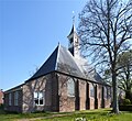
Nederlands: Hervormde Kerk, Sint Laurens - anno 1644
|
This is a category about rijksmonument number 29734
|
| Address |
|
Media in category "Nederlands Hervormde Kerk, Sint Laurens"
The following 38 files are in this category, out of 38 total.
-
 Church Sint Laurens.JPG 3,171 × 2,553; 1.79 MB
-
 Dorpskerk Sint Laurens (1).jpg 2,141 × 1,858; 3.42 MB
-
 Dorpskerk Sint Laurens (2).jpg 2,103 × 1,833; 1.33 MB
-
 Dorpskerk Sint Laurens (3).jpg 1,876 × 1,836; 3.28 MB
-
 Dorpskerk Sint Laurens (4).jpg 2,029 × 1,871; 3.22 MB
-
 Dorpskerk Sint Laurens (5).jpg 2,053 × 1,881; 1.36 MB
-
 Dorpskerk Sint Laurens (6).jpg 2,105 × 1,880; 4.24 MB
-
 Gezicht op het kerkhof van de Hervormde kerk - Sint Laurens - 20129496 - RCE.jpg 1,200 × 1,200; 251 KB
-

-
 Hekpijlers van het kerkhof van de Hervormde kerk - Sint Laurens - 20129576 - RCE.jpg 1,200 × 1,200; 336 KB
-
 Interieur, gedeelte doophek - Sint Laurens - 20349015 - RCE.jpg 1,198 × 1,200; 284 KB
-
 Interieur, gezangenbord - Sint Laurens - 20349017 - RCE.jpg 1,200 × 1,180; 160 KB
-
 Interieur, naar de preekstoel - Sint Laurens - 20129495 - RCE.jpg 1,200 × 962; 174 KB
-
 Interieur, naar het orgel - Sint Laurens - 20129494 - RCE.jpg 1,200 × 949; 191 KB
-
 Interieur, overzicht doophek - Sint Laurens - 20349011 - RCE.jpg 1,200 × 1,185; 236 KB
-
 Interieur, overzicht orgel - Sint Laurens - 20349002 - RCE.jpg 1,185 × 1,200; 251 KB
-
 Interieur, overzicht orgel - Sint Laurens - 20349003 - RCE.jpg 1,189 × 1,200; 216 KB
-

-
 Interieur, overzicht richting het orgel - Sint Laurens - 20348997 - RCE.jpg 1,200 × 947; 188 KB
-
 Interieur, overzicht richting preekstoel - Sint Laurens - 20348999 - RCE.jpg 1,200 × 963; 156 KB
-
 Interieur, overzicht van het orgel - Sint Laurens - 20384847 - RCE.jpg 1,200 × 1,186; 186 KB
-
 Interieur, rouwbord - Sint Laurens - 20349018 - RCE.jpg 1,199 × 1,200; 241 KB
-
 Interieur, rouwbord - Sint Laurens - 20349019 - RCE.jpg 1,199 × 1,200; 202 KB
-
 Interieur, rouwbord - Sint Laurens - 20349020 - RCE.jpg 1,200 × 1,198; 214 KB
-
 Interieur, rouwbord - Sint Laurens - 20349021 - RCE.jpg 1,195 × 1,200; 246 KB
-
 Interieur, rouwbord - Sint Laurens - 20349023 - RCE.jpg 1,196 × 1,200; 244 KB
-
 Interieur, rouwbord - Sint Laurens - 20349024 - RCE.jpg 1,197 × 1,200; 170 KB
-

-

-

-
 Overzicht exterieur Hervormde kerk - Sint Laurens - 20129493 - RCE.jpg 960 × 1,200; 312 KB
-
 Overzicht Hervormde kerk, vanaf de straat - Sint Laurens - 20129492 - RCE.jpg 949 × 1,200; 294 KB
-
 Overzicht Hervormde kerk, vanaf de straat - Sint Laurens - 20129497 - RCE.jpg 803 × 1,200; 170 KB
-

-
 Overzicht voorgevel - Sint Laurens - 20352628 - RCE.jpg 1,200 × 951; 302 KB
-

-

-


.jpg)
.jpg)
.jpg)
.jpg)
.jpg)


