Category:Nederlands Hervormde Kerk, Retranchement
Jump to navigation
Jump to search
| Object location | | View all coordinates using: OpenStreetMap |
|---|
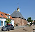
church in Retranchement, Netherlands  | |||||
| Upload media | |||||
| Instance of | |||||
|---|---|---|---|---|---|
| Location | Retranchement, Retranchement | ||||
| Street address |
| ||||
| Located on street |
| ||||
| Heritage designation |
| ||||
| Inception |
| ||||
| Significant event |
| ||||
| Religion or worldview | |||||
 | |||||
Nederlands: Nederlands Hervormde Kerk - anno 1630
|
This is a category about rijksmonument number 33920
|
| Address |
|
Media in category "Nederlands Hervormde Kerk, Retranchement"
The following 13 files are in this category, out of 13 total.
-
 Interieur, gezien naar de preekstoel - Retranchement - 20185632 - RCE.jpg 1,200 × 946; 177 KB
-
 Interieur, gezien naar de preekstoel - Retranchement - 20185634 - RCE.jpg 1,200 × 956; 183 KB
-
 Interieur, gezien naar het orgel - Retranchement - 20185631 - RCE.jpg 1,200 × 941; 183 KB
-
 Interieur, gezien naar het orgel - Retranchement - 20185635 - RCE.jpg 1,200 × 945; 152 KB
-
 Interieur, preekstoel - Retranchement - 20185633 - RCE.jpg 953 × 1,200; 175 KB
-
 Overzicht Hervormde kerk - Retranchement - 20185630 - RCE.jpg 1,780 × 2,556; 830 KB
-
 Overzicht Hervormde kerk, vanaf de straat - Retranchement - 20185636 - RCE.jpg 3,041 × 2,398; 979 KB
-
 Overzicht zuidoostgevel - Retranchement - 20352903 - RCE.jpg 1,172 × 1,200; 292 KB
-
 Overzicht zuidwestgevel - Retranchement - 20352904 - RCE.jpg 1,200 × 1,115; 303 KB
-
 Retranchement - Kerk.jpeg 3,010 × 2,451; 4.29 MB
-
 Retranchement - Kerk.png 1,067 × 800; 2.07 MB
-
 Retranchement - Kerk1.png 3,296 × 2,472; 11.09 MB
-
 Retranchement NHKerk R01.jpg 2,940 × 2,664; 4.39 MB


