Category:Nederlands Hervormde Kerk, Giessenburg
Jump to navigation
Jump to search
| Object location | | View all coordinates using: OpenStreetMap |
|---|
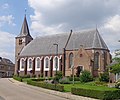
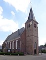
church in Giessenburg, Netherlands  | |||||
| Upload media | |||||
| Instance of | |||||
|---|---|---|---|---|---|
| Location | Giessenburg, South Holland, Netherlands | ||||
| Street address |
| ||||
| Located on street |
| ||||
| Has part(s) | |||||
| Heritage designation |
| ||||
 | |||||
Kerk:
|
This is a category about rijksmonument number 16108
|
Toren:
|
This is a category about rijksmonument number 16109
|
| Address |
|
Subcategories
This category has only the following subcategory.
I
Media in category "Nederlands Hervormde Kerk, Giessenburg"
The following 31 files are in this category, out of 31 total.
-
 Exterieur naar het noord-oosten - Giessenburg - 20078004 - RCE.jpg 1,035 × 1,200; 389 KB
-
 Exterieur naar het noord-westen - Giessenburg - 20078001 - RCE.jpg 1,200 × 868; 351 KB
-
 Exterieur naar het noorden - Giessenburg - 20078000 - RCE.jpg 1,200 × 890; 264 KB
-
 Exterieur naar het noorden - Giessenburg - 20078002 - RCE.jpg 1,200 × 884; 307 KB
-
 Exterieur naar het oosten - Giessenburg - 20078012 - RCE.jpg 947 × 1,200; 216 KB
-
 Exterieur naar het westen - Giessenburg - 20078005 - RCE.jpg 883 × 1,200; 324 KB
-
 Exterieur naar het zuid-oosten - Giessenburg - 20077999 - RCE.jpg 882 × 1,200; 195 KB
-
 Exterieur naar het zuid-oosten - Giessenburg - 20078003 - RCE.jpg 881 × 1,200; 261 KB
-
 Giessenburg NH Kerk (1).jpg 3,735 × 3,103; 4.74 MB
-
 Giessenburg NH Kerk (2).jpg 3,341 × 2,548; 2.75 MB
-
 Giessenburg NH Kerk (3).jpg 2,882 × 3,705; 3.64 MB
-
 Koor - Giessenburg - 20078009 - RCE.jpg 954 × 1,200; 294 KB
-
 Koor - Giessenburg - 20078010 - RCE.jpg 950 × 1,200; 320 KB
-
 Naar het westen - Giessenburg - 20078016 - RCE.jpg 944 × 1,200; 324 KB
-
 Noord-gevel - Giessenburg - 20078013 - RCE.jpg 1,200 × 939; 251 KB
-
 Noord-gevel, koor - Giessenburg - 20078018 - RCE.jpg 957 × 1,200; 261 KB
-
 Noord-west gevel - Giessenburg - 20078026 - RCE.jpg 947 × 1,200; 181 KB
-
 Ontwerptekening - Giessenburg - 20078024 - RCE.jpg 1,200 × 876; 111 KB
-
 Oostgevel - Giessenburg - 20078029 - RCE.jpg 956 × 1,200; 310 KB
-
 Oostgevel - Giessenburg - 20269950 - RCE.jpg 1,200 × 955; 273 KB
-
 Overzicht zuidgevel - Giessenburg - 20269952 - RCE.jpg 1,200 × 949; 203 KB
-
 Overzicht zuidzijde - Giessenburg - 20324192 - RCE.jpg 845 × 1,200; 160 KB
-
 RM16108 - Kerk Giessenburg.jpg 2,592 × 1,944; 1.6 MB
-
 Schip zuidzijde - Giessenburg - 20324145 - RCE.jpg 1,200 × 858; 218 KB
-
 Toren - Giessenburg - 20078011 - RCE.jpg 945 × 1,200; 238 KB
-
 Uitbouw aan koor - Giessenburg - 20078017 - RCE.jpg 945 × 1,200; 332 KB
-
 Zuid aanzicht - Giessenburg - 20078014 - RCE.jpg 1,200 × 951; 222 KB
-
 Zuid-gevel - Giessenburg - 20078015 - RCE.jpg 939 × 1,200; 338 KB
-
 Zuidgevel - Giessenburg - 20078027 - RCE.jpg 1,200 × 960; 284 KB
-
 Zuidgevel - Giessenburg - 20269951 - RCE.jpg 1,200 × 961; 285 KB
-
 Zuidgevel koor - Giessenburg - 20078028 - RCE.jpg 953 × 1,200; 292 KB


.jpg)
.jpg)
.jpg)


