Category:Nederlands Hervormde Kerk, Dirksland
Jump to navigation
Jump to search
| Object location | | View all coordinates using: OpenStreetMap |
|---|
church building in Goeree-Overflakkee, Netherlands  | |||||
| Upload media | |||||
| Instance of | |||||
|---|---|---|---|---|---|
| Location | Dirksland, South Holland, Netherlands | ||||
| Street address |
| ||||
| Heritage designation |
| ||||
 | |||||
Nederlands: Dorpskerk - anno 16e eeuw
|
This is a category about rijksmonument number 10260
|
| Address |
|
Media in category "Nederlands Hervormde Kerk, Dirksland"
The following 54 files are in this category, out of 54 total.
-
 Dirksland Nederlands Hervormde Kerk 2011.jpg 600 × 900; 373 KB
-
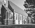
 Exterieur - Dirksland - 20057672 - RCE.jpg 895 × 1,200; 305 KB
-
 Exterieur - Dirksland - 20057673 - RCE.jpg 1,200 × 895; 195 KB
-
 Exterieur noord-gevel - Dirksland - 20057686 - RCE.jpg 953 × 1,200; 338 KB
-
 Exterieur noord-oost zijde - Dirksland - 20057687 - RCE.jpg 1,200 × 958; 340 KB
-
 Exterieur noord-oost zijde - Dirksland - 20057688 - RCE.jpg 1,200 × 958; 219 KB
-
 Exterieur noord-west zijde - Dirksland - 20057683 - RCE.jpg 962 × 1,200; 265 KB
-
 Exterieur noord-zijde - Dirksland - 20057684 - RCE.jpg 1,200 × 964; 236 KB
-
 Exterieur noord-zijde - Dirksland - 20057685 - RCE.jpg 3,089 × 2,469; 2.72 MB
-
 Exterieur oost-zijde - Dirksland - 20057690 - RCE.jpg 952 × 1,200; 301 KB
-
 Exterieur west-zijde - Dirksland - 20057680 - RCE.jpg 954 × 1,200; 333 KB
-
 Exterieur west-zijde - Dirksland - 20057682 - RCE.jpg 949 × 1,200; 328 KB
-
 Exterieur zuid-gevel - Dirksland - 20057693 - RCE.jpg 951 × 1,200; 342 KB
-
 Exterieur zuid-oost zijde - Dirksland - 20057689 - RCE.jpg 955 × 1,200; 359 KB
-
 Exterieur zuid-west zijde - Dirksland - 20057681 - RCE.jpg 1,200 × 961; 288 KB
-
 Exterieur zuid-zijde - Dirksland - 20057692 - RCE.jpg 1,200 × 959; 331 KB
-
 Exterieur zuid-zijde - Dirksland - 20057694 - RCE.jpg 955 × 1,200; 285 KB
-
 Exterieur zuid-zijde - Dirksland - 20057695 - RCE.jpg 956 × 1,200; 299 KB
-
 Exterieur zuid-zijde - Dirksland - 20057697 - RCE.jpg 1,200 × 960; 287 KB
-
 Exterieur zuid-zijde koor - Dirksland - 20057696 - RCE.jpg 960 × 1,200; 333 KB
-
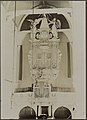 Interieur hervormde kerk- overzicht orgel - Dirksland - 20319928 - RCE.jpg 872 × 1,200; 150 KB
-
 Interieur hervormde kerk- zicht op orgel - Dirksland - 20319929 - RCE.jpg 868 × 1,200; 142 KB
-
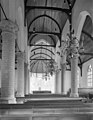 Interieur naar het oosten - Dirksland - 20057699 - RCE.jpg 933 × 1,200; 179 KB
-
 Interieur naar het oosten - Dirksland - 20057700 - RCE.jpg 955 × 1,200; 177 KB
-
 Interieur naar het westen - Dirksland - 20057698 - RCE.jpg 952 × 1,200; 173 KB
-
 Interieur naar het zuid-oosten - Dirksland - 20057701 - RCE.jpg 954 × 1,200; 182 KB
-
 Interieur zuid beuk naar het oosten - Dirksland - 20057702 - RCE.jpg 951 × 1,200; 178 KB
-
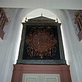 Interieur, dubbelzijdig beschilderd kerkbord uit 1611 - Dirksland - 20384067 - RCE.jpg 1,200 × 1,198; 148 KB
-
 Interieur, dubbelzijdig beschilderd kerkbord uit 1611 - Dirksland - 20384068 - RCE.jpg 1,200 × 1,193; 180 KB
-
-

-

-

-

-

-
 Interieur, zicht op orgel en kansel - Dirksland - 20057676 - RCE.jpg 840 × 1,200; 227 KB
-

-
 Inwendig, naar het westen - Dirksland - 20057675 - RCE.jpg 940 × 1,200; 187 KB
-
 Kerk en toren ten zuid-westen - Dirksland - 20057671 - RCE.jpg 858 × 1,200; 250 KB
-
 Mosvorming op de toren westzijde - Dirksland - 20057713 - RCE.jpg 949 × 1,200; 293 KB
-
 Mosvorming op de toren westzijde - Dirksland - 20057714 - RCE.jpg 1,193 × 1,200; 399 KB
-
 Mosvorming op de toren zuidzijde - Dirksland - 20057715 - RCE.jpg 1,190 × 1,200; 431 KB
-
 Orgel - Dirksland - 20057678 - RCE.jpg 952 × 1,200; 185 KB
-
 Overzicht zuid-zijde - Dirksland - 20057691 - RCE.jpg 1,200 × 960; 230 KB
-
 Tekstbord in portaal - Dirksland - 20057711 - RCE.jpg 1,200 × 1,200; 206 KB
-
 Tekstbord in portaal - Dirksland - 20057712 - RCE.jpg 1,195 × 1,200; 236 KB
-
 Toren exterieur west-zijde - Dirksland - 20057679 - RCE.jpg 932 × 1,200; 216 KB
-
 Tracering aan het koor, noord-oost - Dirksland - 20057674 - RCE.jpg 947 × 1,200; 359 KB
-
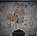
 Wandschildering achter orgel - Dirksland - 20057705 - RCE.jpg 959 × 1,200; 150 KB
-
 Wandschildering achter orgel - Dirksland - 20057706 - RCE.jpg 954 × 1,200; 138 KB
-
 Wandschildering achter orgel - Dirksland - 20057707 - RCE.jpg 1,200 × 943; 270 KB
-
 Wandschildering achter orgel - Dirksland - 20057708 - RCE.jpg 960 × 1,200; 233 KB
-
 Wandschildering achter orgel - Dirksland - 20057709 - RCE.jpg 960 × 1,200; 215 KB
-
 Wandschildering achter orgel - Dirksland - 20057710 - RCE.jpg 960 × 1,200; 234 KB


