Category:Nederlands Hervormde Kerk, De Lier
Jump to navigation
Jump to search
| Object location | | View all coordinates using: OpenStreetMap |
|---|
church building in Westland, Netherlands  | |||||
| Upload media | |||||
| Instance of | |||||
|---|---|---|---|---|---|
| Location | De Lier, De Lier | ||||
| Street address |
| ||||
| Heritage designation |
| ||||
 | |||||
|
This is a category about rijksmonument number 25879
|
| Address |
|
Media in category "Nederlands Hervormde Kerk, De Lier"
The following 40 files are in this category, out of 40 total.
-
 Atlas Schoemaker-ZUIDHOLLAND-DEEL4-2000-Zuid-Holland, De Lier.jpeg 1,023 × 1,664; 212 KB
-
 Atlas Schoemaker-ZUIDHOLLAND-DEEL4-2001-Zuid-Holland, De Lier.jpeg 1,023 × 1,664; 314 KB
-

-
 De Dom - De Lier - 2008 - panoramio.jpg 1,728 × 2,304; 1.01 MB
-
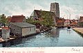 De lier 1904.jpg 820 × 516; 55 KB
-
 De Lier Domtoren.jpg 1,944 × 2,592; 2.57 MB
-
 De Lier, kerk1 foto1 2009-08-23 16.26.JPG 1,944 × 2,592; 867 KB
-
 Detail opname bovenste lid west-zijde - De Lier - 20139917 - RCE.jpg 1,200 × 948; 327 KB
-
 Detail opname bovenste lid west-zijde - De Lier - 20139918 - RCE.jpg 1,200 × 950; 378 KB
-
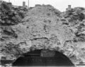 Detail opname bovenste lid west-zijde - De Lier - 20139919 - RCE.jpg 1,200 × 954; 315 KB
-
 Domkerk De Lier 01.jpg 4,032 × 3,024; 5.4 MB
-
 Domkerk De Lier 02.jpg 4,032 × 3,024; 3.6 MB
-
 Domkerk De Lier 03.jpg 4,032 × 3,024; 4.03 MB
-
 Domkerk De Lier 04.jpg 4,032 × 3,024; 4.02 MB
-
 Domkerk De Lier 05.jpg 4,032 × 3,024; 4.3 MB
-
 Domkerk De Lier 06.jpg 4,032 × 3,024; 3.38 MB
-
 Domkerk De Lier 07.jpg 4,032 × 3,024; 4.26 MB
-
 Domkerk De Lier 08.jpg 4,032 × 3,024; 4.56 MB
-
 Domkerk De Lier 09.jpg 4,032 × 3,024; 4.06 MB
-
 Domkerk De Lier 10.jpg 4,032 × 3,024; 4 MB
-
 Domkerk De Lier 11.jpg 4,032 × 3,024; 3.96 MB
-
 Domkerk De Lier 12.jpg 4,032 × 3,024; 4.04 MB
-
 Domkerk De Lier 13.jpg 4,032 × 3,024; 4.04 MB
-
 Domkerk De Lier 14.jpg 4,032 × 3,024; 3.34 MB
-
 Domkerk De Lier 15.jpg 4,032 × 3,024; 3.01 MB
-
-
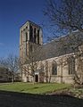
 Exterieur naar het noorden - De Lier - 20139903 - RCE.jpg 1,200 × 865; 188 KB
-
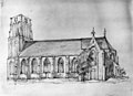
 Gedeelte van zuidgevel met toren - De Lier - 20390022 - RCE.jpg 921 × 1,200; 273 KB
-

-
 Gezicht-op-de-lier, Anton van Teyn.png 700 × 385; 583 KB
-
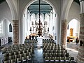
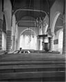
 Interieur naar het oosten - De Lier - 20139905 - RCE.jpg 941 × 1,200; 194 KB
-
 Interieur naar het oosten - De Lier - 20139920 - RCE.jpg 958 × 1,200; 172 KB
-
 Interieur naar het oosten - De Lier - 20139922 - RCE.jpg 935 × 1,200; 169 KB
-
 Interieur naar het westen - De Lier - 20139921 - RCE.jpg 957 × 1,200; 205 KB
-
 Interieur naar het westen - De Lier - 20139923 - RCE.jpg 964 × 1,200; 197 KB
-
 Kerk naar het noorden, Hs.Verhees - De Lier - 20139898 - RCE.jpg 860 × 1,200; 222 KB
-
 Koor - De Lier - 20139901 - RCE.jpg 1,200 × 881; 264 KB
-
 Overzicht op de westgevel van de toren - De Lier - 20390023 - RCE.jpg 926 × 1,200; 286 KB
-
 Overzicht zuidgevel - De Lier - 20390024 - RCE.jpg 927 × 1,200; 317 KB
-
 Westland-De Lier, de Domkerk RM25879 IMG 0486 2024-04-07 12.17.jpg 3,355 × 5,232; 11.79 MB


