Category:Nautical charts of France
Jump to navigation
Jump to search
Subcategories
This category has only the following subcategory.
Media in category "Nautical charts of France"
The following 5 files are in this category, out of 5 total.
-
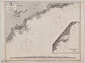 Admiralty Chart No 2609 France south coast Rade d'Agay to San Remo, Published 1858.jpg 8,336 × 6,155; 5.7 MB
-
 Admiralty Chart No 2609 Rade d'Agay to St Remo, Published 1858, New Edition 1880.jpg 11,231 × 8,499; 25.8 MB
-
 Minute du plan d'Arzeu près d'Oran, côte de Barbarie - btv1b532423359 (1 of 2).jpg 11,944 × 6,712; 6.31 MB
-
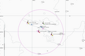 Plateau de Rochebonne.PNG 1,164 × 772; 48 KB
-
 Seine estuaire 1875.jpg 736 × 493; 40 KB


.jpg)

