Category:Naturschutzgebiet Wutachschlucht
Jump to navigation
Jump to search
| Diese Kategorie repräsentiert ein Schutzgebiet nach Naturschutzrecht in Deutschland. |
|---|
| Diese Kategorie wurde nach einem klaren Schema angelegt, sie sollte nicht verschoben, gelöscht oder umkategorisiert werden. Sie ist unter anderem in dieser Uploadkarte hinterlegt. Beschreibung und Hintergründe auf der Seite des Wikiprojekts |
| Foto zu Wiki Loves Earth hochladen! - Seite von Wiki Loves Earth Deutschland |
nature reserve in Baden-Württemberg, Germany  | |||||
| Upload media | |||||
| Instance of | |||||
|---|---|---|---|---|---|
| Named after | |||||
| Location | |||||
| IUCN protected areas category | |||||
| Inception |
| ||||
| Area |
| ||||
| official website | |||||
 | |||||
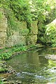
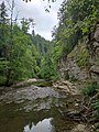
Deutsch: Naturschutzgebiet „Wutachschlucht“, NSG 3.024 in den Landkreisen Breisgau-Hochschwarzwald, Waldshut und im Schwarzwald-Baar-Kreis, Baden-Württemberg
English: "Wutachschlucht" (Wutach gorges) nature reserve in Baden-Württemberg, Germany
Subcategories
This category has the following 13 subcategories, out of 13 total.
B
D
- Dietfurter Wasserfall (7 F)
F
- Flusskraftwerk Stallegg (13 F)
G
H
K
- Kanadiersteg (4 F)
L
R
- Rechenfelsen (6 F)
- Rümmelesteg (4 F)
S
- Stallegger Brücke (4 F)
T
- Tannegger Wasserfall (10 F)
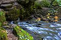
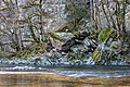
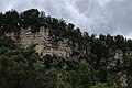
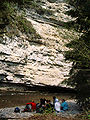
Media in category "Naturschutzgebiet Wutachschlucht"
The following 85 files are in this category, out of 85 total.
-
 2016-10-07 Wutach-Schlucht Landkreis Waldshut BW WiTi 02.tif 1,536 × 2,304; 10.14 MB
-
 20220518105336 IMG 4582.jpg 3,368 × 6,000; 4.66 MB
-
 20220518105430 IMG 4583.jpg 3,368 × 6,000; 7.3 MB
-
 20220518105914 IMG 4585.jpg 3,368 × 6,000; 7.33 MB
-
 20220518111014 IMG 4588.jpg 3,368 × 6,000; 9.04 MB
-
 20220518111724 IMG 4591.jpg 3,368 × 6,000; 5.75 MB
-
 20220518113042 IMG 4593.jpg 2,356 × 4,197; 2.91 MB
-
 20220518115010 IMG 4599.jpg 3,368 × 6,000; 3.14 MB
-
 20220518131301 IMG 4611.jpg 2,692 × 4,795; 2.48 MB
-
 20220518131501 IMG 4614.jpg 3,368 × 6,000; 9.76 MB
-
 20220518133342 IMG 4619.jpg 3,368 × 6,000; 8.39 MB
-
 20220518134843 IMG 4624.jpg 3,368 × 6,000; 7.87 MB
-
 20220518134921 IMG 4625.jpg 3,368 × 6,000; 6.87 MB
-
 20220518140104 IMG 4628.jpg 3,368 × 6,000; 7.85 MB
-
Achdorf Dorfportrait.webm 6 min 10 s, 1,440 × 1,080; 134.97 MB
-
Achdorf Mit Wueteknü - Portrait.ogv 6 min 10 s, 1,920 × 1,080; 1.2 GB
-
 Brücke über die Wutach beim ehem Bad Boll.jpg 7,952 × 5,304; 21.53 MB
-
 Brücke über die Wutach nahe dem Dietfurter Wasserfall.jpg 7,697 × 5,132; 15.98 MB
-
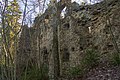
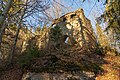 Burgruine Neu-Tannegg - Bonndorf im Schwarzwald Bild 1.jpg 7,952 × 5,304; 24.93 MB
-
 Burgruine Neu-Tannegg - Bonndorf im Schwarzwald Bild 2.jpg 7,952 × 5,304; 15.37 MB
-
 Burgruine Neu-Tannegg - Bonndorf im Schwarzwald Bild 3.jpg 7,952 × 5,304; 19.16 MB
-
 Eisige Felsen voller Eiszapfen in der Wutachschlucht.jpg 5,184 × 3,456; 14.1 MB
-
 Felsengalerie Wutachschlucht.jpg 2,448 × 3,264; 3.34 MB
-
 Felsenpfad Wutachschlucht.jpg 3,096 × 4,128; 6.95 MB
-
 Gaschthuus Schattèmülli.JPG 6,016 × 4,000; 6.32 MB
-
 Grün im Winter, bemooster Nadelbaum in der Wutachschlucht zur Winterzeit.jpg 5,184 × 3,456; 9.09 MB
-
 Mosses Pathway.jpg 3,120 × 4,160; 7.62 MB
-

-
Naturschutzgebiet Wutachschlucht Boll-Schurhammerhütte-Boll.webm 3 min 10 s, 1,920 × 1,080; 91.52 MB
-
 Naturschutzgebiet Wutachschlucht IMG 2881.jpg 6,014 × 4,003; 36.86 MB
-
 Naturschutzgebiet Wutachschlucht IMG 2882.jpg 5,877 × 3,906; 32.12 MB
-
 Naturschutzgebiet Wutachschlucht IMG 2883.jpg 5,916 × 3,932; 33.3 MB
-
 Naturschutzgebiet Wutachschlucht IMG 2889.jpg 4,003 × 6,014; 33.96 MB
-
 Naturschutzgebiet Wutachschlucht IMG 2890.jpg 4,003 × 6,014; 37.16 MB
-
 Naturschutzgebiet Wutachschlucht IMG 2896.jpg 6,014 × 4,003; 34.16 MB
-
 Naturschutzgebiet Wutachschlucht IMG 2898.jpg 5,768 × 3,834; 31.33 MB
-
 Naturschutzgebiet Wutachschlucht IMG 2903.jpg 6,014 × 4,003; 37.21 MB
-
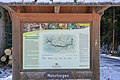 Naturschutzgebiet Wutachschlucht Infotafel.jpg 7,952 × 5,304; 2.56 MB
-
 Naturschutzgebiet Wutachschlucht Lage.jpg 1,444 × 731; 793 KB
-
 Naturschutzgebiet Wutachschlucht.jpg 2,400 × 1,600; 3.78 MB
-
 NSG Wutachschlucht 02.jpg 4,736 × 3,098; 4.94 MB
-
 NSG Wutachschlucht 04.jpg 5,184 × 3,456; 5.46 MB
-
 Powers of the earth.jpg 3,908 × 2,600; 6.34 MB
-
 Rötenbachschlucht 24052016.jpg 5,312 × 2,988; 7.09 MB
-
 Sauschwänzlebahn 2020-07gWutachschluchtFelsen.jpg 6,000 × 4,000; 13.66 MB
-
 Schurhammerhütte.jpg 1,960 × 2,528; 1.39 MB
-
 StalleggerTanneUndAnne.JPG 4,000 × 6,016; 6.41 MB
-
 Steg BeiBadBoll.JPG 6,016 × 4,000; 6.42 MB
-
 Steinstapel Wutachschlucht.jpg 3,000 × 4,000; 8.37 MB
-
 Tafel StalleggerTanne.JPG 6,016 × 4,000; 6.31 MB
-
 Urdonau+Donau-Historie Schwaebische-Alb.jpg 1,800 × 1,414; 918 KB
-
 Von Pilz befallener alter Baumstumpf mit Blick auf Hammerbach in der Wutachschlucht.jpg 5,184 × 3,456; 14.47 MB
-
 Winterwasser Schluchtentreffen der drei Schluchten im Winter.jpg 5,184 × 3,456; 14.01 MB
-
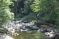
 Wutach - Gauchach - Confluence 01.jpg 6,000 × 4,000; 21.77 MB
-
 Wutach 25000 F.jpg 6,000 × 4,000; 10.22 MB
-
 Wutach Austritt.jpg 4,000 × 3,000; 8.62 MB
-
 Wutach bei Bad Boll.jpg 4,032 × 2,272; 3.32 MB
-
 Wutach Gorge.jpg 4,749 × 2,243; 5.78 MB
-
 Wutach Muschelkalk-Aufschluss.jpg 1,200 × 1,800; 1.91 MB
-
 Wutach Muschelkalk.JPG 1,200 × 1,600; 1.5 MB
-
 Wutach w-o-GeoSchnitt.jpg 1,800 × 507; 425 KB
-
 Wutach.JPG 2,848 × 4,272; 11.42 MB
-
 Wutach0710-01.jpg 2,112 × 2,816; 3.43 MB
-
 Wutachschlucht (mittl).jpg 2,560 × 1,920; 4.84 MB
-
 Wutachschlucht 1.jpg 4,724 × 2,657; 13.71 MB
-
 Wutachschlucht 2.jpg 4,724 × 2,657; 13.02 MB
-
 Wutachschlucht 2022.jpg 3,000 × 4,000; 8.52 MB
-
 Wutachschlucht 3.jpg 4,724 × 2,657; 13.2 MB
-
 Wutachschlucht 4.jpg 4,724 × 2,657; 15.53 MB
-
 Wutachschlucht 5.jpg 4,724 × 2,657; 19.54 MB
-
 Wutachschlucht 6.jpg 4,724 × 2,657; 16.57 MB
-
 Wutachschlucht 7.jpg 4,724 × 2,657; 16.55 MB
-
 Wutachschlucht 9stämmige Buche.jpg 1,392 × 2,175; 381 KB
-
 Wutachschlucht am Raeuberschloessle 20230727 0954.jpg 2,602 × 1,886; 1.55 MB
-
 Wutachschlucht Ausblick Felsengalerie.jpg 3,000 × 4,000; 9.12 MB
-
 Wutachschlucht Felswand.jpg 3,000 × 4,000; 9.25 MB
-
 Wutachschlucht Muschelkalk Felswand-mit-Druckstoerung Schwarzwald Deutschland.jpg 1,200 × 1,800; 2.59 MB
-
 Wutachschlucht Stallegg.jpg 886 × 1,304; 577 KB
-
 Wutachschlucht vom Kanzelfels.jpg 1,034 × 1,518; 601 KB
-
 Wutachschlucht, Nähe Engländer Allee.jpg 2,448 × 3,264; 2.9 MB
-
 Wutachschlucht-Felsgesicht.JPG 2,816 × 2,112; 3.88 MB
-
 Wutachschlucht-maerzenbecher.jpg 2,016 × 3,024; 1.15 MB
-
 Wutachschlucht.jpg 2,048 × 1,536; 1.16 MB
-
 Wutachtal 2.jpg 2,592 × 1,936; 4.76 MB
-
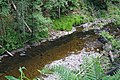
 Übergang der Gauchach in die Wutach.jpg 1,920 × 1,280; 3.57 MB


_spec._-_Arionidae_-_Mollusc_shell.jpeg)


.jpg)


Categories:
- National geotopes in Baden-Württemberg
- Nature reserves in Landkreis Waldshut
- Nature reserves in Landkreis Breisgau-Hochschwarzwald
- Nature reserves in Schwarzwald-Baar-Kreis
- Friedenweiler
- Lenzkirch
- Löffingen
- Bräunlingen
- Hüfingen
- Bonndorf im Schwarzwald
- Wutach (Gemeinde)
- Nature reserves in the Black Forest
- Wutach (river)
- Wutachtal
- Naturpark Südschwarzwald
- Canyons in Baden-Württemberg
- Stratigraphy of Baden-Württemberg
- Vogelschutzgebiet Wutach und Baaralb
- FFH-Gebiet Wutachschlucht
- Schluchtensteig
- Schwarzwald-Querweg Freiburg–Bodensee