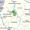
Category:Naturpark Teutoburger Wald/Eggegebirge
Jump to navigation
Jump to search
nature park in North Rhine-Westphalia, Germany | |||||
| Upload media | |||||
| Instance of | |||||
|---|---|---|---|---|---|
| Named after | |||||
| Location |
| ||||
| Inception |
| ||||
| Area |
| ||||
| Elevation above sea level |
| ||||
 | |||||
Subcategories
This category has the following 20 subcategories, out of 20 total.
B
- Breitehalshöhle (3 F)
D
E
F
- Feldromer Berg (9 F)
H
- Hohlsteinhöhle (empty)
- Hohlweg Große Egge (14 F)
K
- Kleiner Rigi (6 F)
L
- Lukenloch (3 F)
N
- Naturschutzgebiet Berlebecke (26 F)
T
V
W
Media in category "Naturpark Teutoburger Wald/Eggegebirge"
The following 70 files are in this category, out of 70 total.
-
Baumwurzel am Lämmerweg, Bielefeld.jpg 3,264 × 4,912; 6.57 MB
-
Blick auf Deutschland kleinster Vulkan Sandebeck Lippe.jpg 3,840 × 2,160; 2.05 MB
-
Blick vom kleinen Rigi in Richtung Egge.jpg 2,560 × 1,920; 611 KB
-
Blomberg - 2022-03-18 - Reiher Donop (DSC 5397).jpg 4,500 × 3,204; 7.98 MB
-
Blomberg - 2022-03-18 - Reiher Donop (DSC 5404).jpg 4,500 × 3,210; 8.64 MB
-
Blomberg - 2022-03-18 - Störche Donop (DSC 5355).jpg 4,500 × 3,010; 6.8 MB
-
Blomberg - 2022-03-18 - Störche Donop (DSC 5369).jpg 4,500 × 3,385; 6.87 MB
-
Blomberg - 2022-03-18 - Störche Donop (DSC 5370).jpg 4,500 × 2,880; 5.97 MB
-
Blomberg - 2022-03-18 - Störche Donop (DSC 5371).jpg 4,500 × 2,888; 6.01 MB
-
Blomberg - 2022-03-18 - Störche Donop (DSC 5375).jpg 4,500 × 2,837; 6.35 MB
-
Blomberg - 2022-03-18 - Störche Donop (DSC 5377).jpg 4,500 × 3,112; 6.9 MB
-
Blomberg - 2022-03-18 - Störche Donop (DSC 5378).jpg 4,500 × 2,944; 6.43 MB
-
Blomberg - 2022-03-18 - Störche Donop (DSC 5380).jpg 4,500 × 2,957; 6.66 MB
-
Blomberg - 2022-03-18 - Störche Donop (DSC 5382).jpg 4,500 × 2,845; 6.09 MB
-
Blomberg - 2022-03-18 - Störche Donop (DSC 5386).jpg 4,500 × 2,820; 6.47 MB
-
Blomberg - 2022-03-18 - Störche Donop (DSC 5387).jpg 4,500 × 3,012; 6.95 MB
-
Blomberg - 2022-03-18 - Störche Donop (DSC 5393).jpg 4,500 × 3,030; 7.23 MB
-
Blomberg - 2022-03-18 - Störche Donop (DSC 5401).jpg 4,500 × 3,044; 8.35 MB
-
Buchen am Lämmerweg, Teutoburger Wald bei Bielefeld-Lämershagen.jpg 3,264 × 4,912; 5.68 MB
-
Detmold - 2014-06-01 - LIP-066 - Alter Postweg (24).jpg 3,000 × 2,000; 3.99 MB
-
Detmold - 2014-06-25 - Helix pomatia (10).jpg 3,000 × 2,000; 4.43 MB
-
Detmold - 2014-06-25 - Helix pomatia (12).jpg 3,000 × 2,000; 4.51 MB
-
Detmold - 2014-06-25 - Helix pomatia (14).jpg 2,094 × 3,000; 4.69 MB
-
Detmold - 2014-06-25 - Helix pomatia (15).jpg 3,000 × 2,311; 4.92 MB
-
Detmold - 2014-06-25 - Helix pomatia (18).jpg 3,000 × 2,750; 5.74 MB
-
Detmold - 2014-06-25 - Helix pomatia (27).jpg 2,341 × 3,000; 4.75 MB
-
Detmold - 2014-06-25 - Helix pomatia (30).jpg 2,364 × 3,000; 5.03 MB
-
Detmold - 2014-06-25 - Helix pomatia (32).jpg 3,000 × 2,000; 4.74 MB
-
Detmold - 2014-06-25 - Helix pomatia (36).jpg 3,000 × 2,000; 4.76 MB
-
Detmold - 2014-06-25 - Helix pomatia (38).jpg 3,000 × 2,000; 4.49 MB
-
Detmold - 2014-06-25 - Helix pomatia (39).jpg 3,000 × 1,967; 3.89 MB
-
Detmold - 2014-06-25 - Helix pomatia (40).jpg 2,160 × 3,000; 4.27 MB
-
Detmold - 2014-06-25 - Helix pomatia (8).jpg 3,000 × 2,000; 4.18 MB
-
Eiserner-anton-aussicht-sonnenuntergang.jpg 3,024 × 4,032; 1.43 MB
-
Eiserner-anton-bismarckturm.jpg 3,024 × 4,032; 6.28 MB
-
Eiserner-anton-geländer.jpg 1,134 × 2,108; 528 KB
-
Externsteine-Gela2.JPG 1,920 × 2,560; 2.08 MB
-
Farnkopf am Lämmerweg bei Bielefeld-Lämershagen.jpg 4,912 × 3,264; 2.38 MB
-
Farnwald auf dem Lämmerweg, Teutoburgerwald,Bielefeld.jpg 4,912 × 3,264; 6.79 MB
-
Hermannsweg-sonnenaufgang.jpg 4,032 × 3,024; 4.96 MB
-
Hochsitz mit Wurzel Teutoburger Wald bei Bielefeld-Lämershagen.jpg 3,264 × 4,912; 7.36 MB
-
Informationstafel 4 - vom Naturweg zur asphaltierten Straeße.jpg 2,048 × 1,157; 392 KB
-
Infotafel 1.jpg 3,494 × 2,211; 1.34 MB
-
Infotafel 2.jpg 3,466 × 2,102; 1.01 MB
-
Infotafel 5.jpg 3,217 × 2,099; 1.06 MB
-
Johannisbuche auf dem "runden Knapp" bei Höxter.jpg 2,448 × 3,264; 4.49 MB
-
Karte Naturpark Teutoburger Wald-Eggegebirge.png 750 × 1,000; 205 KB
-
Lippspringer Wald 17869-20170527 1018111052055576.jpg 2,160 × 2,160; 4.05 MB
-
Lämmerweg im Teutoburgerwald, Sandige Erde, Reiterweg.jpg 4,912 × 3,264; 6.85 MB
-
Lämmerweg Teutoburgerwald,der Reiterweg,.jpg 3,264 × 4,912; 5.38 MB
-
Lämmerweg, Leopoldshöhe, Bielefeld Teutoburger Wald.jpg 4,912 × 3,264; 4.05 MB
-
Moos bewachsene Baumwurzel auf dem Lämmerweg. Teutoburger Wald.jpg 4,912 × 3,264; 6.77 MB
-
Parkplatz, Eisgrund, Leopoldshöhe- Bielefeld.jpg 4,912 × 3,264; 5.09 MB
-
Schiedersee-Flußauen im Mai mit blühendem Raps.JPG 3,648 × 2,736; 2.29 MB
-
Sehr alter Baumstumpf, Eisgrund nähe des Parkplatzes, Bielefeld.jpg 3,264 × 4,912; 7.56 MB
-
Senne12.jpg 1,600 × 1,200; 827 KB
-
Steinheim-Sandebeck - 2019-09-02 - LSG Naturpark (DSC01817).jpg 4,500 × 3,000; 9.4 MB
-
Steinheim-Sandebeck - 2019-09-02 - LSG Naturpark (DSC01819).jpg 4,500 × 3,000; 9.21 MB
-
Steinheim-Sandebeck - 2019-09-02 - LSG Naturpark (DSC01821).jpg 4,500 × 3,000; 10.22 MB
-
Steinheim-Sandebeck - 2019-09-02 - LSG Naturpark (DSC01823).jpg 4,500 × 3,000; 11.91 MB
-
Steinheim-Sandebeck - 2019-09-02 - LSG Naturpark (DSC01824).jpg 4,500 × 3,000; 13.8 MB
-
Steinheim-Sandebeck - 2019-09-02 - LSG Naturpark (DSC01825).jpg 4,500 × 3,000; 10.11 MB
-
Steinheim-Sandebeck - 2019-09-02 - LSG Naturpark (DSC01826).jpg 4,500 × 3,000; 11.51 MB
-
Steinheim-Sandebeck - 2019-09-02 - LSG Naturpark (DSC01827).jpg 4,500 × 3,000; 11.67 MB
-
Teutoburger Wald Parkplatz Leopoldshöhe, Bielefeld.jpg 4,912 × 3,264; 4.18 MB
-
Wald-Bingelkraut, Teutoburger Wald, Lämershagen.jpg 4,912 × 3,264; 5.13 MB
-
Waldfarn, Teutoburgerwald.jpg 4,912 × 3,264; 4.53 MB
-
Wegweiser-zum-eisernen-anton.jpg 3,024 × 4,032; 6.17 MB
-
Wendlinghausen.Dörentrup,Löhlberg.jpg 4,928 × 3,264; 6.95 MB


