Help
Category
:
Natomas Ditch System
From Wikimedia Commons, the free media repository
Jump to navigation
Jump to search
Media in category "Natomas Ditch System"
The following 38 files are in this category, out of 38 total.
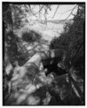
Dense riparian vegetation at old bridge on Silberstein property - Natomas Ditch System, Blue Ravine Segment, Juncture of Blue Ravine and Green Valley Roads, Folsom, Sacramento HAER CAL,37-FOLSO.V,1A-4.tif
5,000 × 4,025; 19.2 MB
Detail of earthen bank of ditch near south end of project - Natomas Ditch System, Blue Ravine Segment, Juncture of Blue Ravine and Green Valley Roads, Folsom, Sacramento HAER CAL,37-FOLSO.V,1A-13.tif
5,000 × 4,050; 19.31 MB
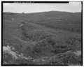
Earthen banked ditch and view of fields to south - Natomas Ditch System, Blue Ravine Segment, Juncture of Blue Ravine and Green Valley Roads, Folsom, Sacramento County, CA HAER CAL,37-FOLSO.V,1A-6.tif
5,000 × 4,016; 19.15 MB
CUT THROUGH SLATY ROCKS, LOOKING NORTHEAST TO EL DORADO HILLS. - Natomas Ditch System, Rhodes Ditch, West of Bidwell Street, north of U.S. Highway 50, Folsom, Sacramento HAER CAL,3-FOLSO.V,1B-14.tif
5,000 × 4,005; 19.1 MB
DITCH NEAR NORTH PROJECT BOUNDARY. VIEW TO SOUTHEAST. - Natomas Ditch System, Rhodes Ditch, West of Bidwell Street, north of U.S. Highway 50, Folsom, Sacramento County, CA HAER CAL,3-FOLSO.V,1B-2.tif
4,049 × 5,000; 19.31 MB
FOLSOM, CALIFORNIA, 15 MINUTE QUADRANGLE. 1941. Scale 1-62,500. United States Geological Survey. - Natomas Ditch System, Rhodes Ditch, West of Bidwell Street, north of U.S. HAER CAL,3-FOLSO.V,1B-25.tif
5,000 × 4,002; 19.09 MB
Inverted siphon structure carrying ditch flow under Willow Creek, looking east - Natomas Ditch System, Blue Ravine Segment, Juncture of Blue Ravine and Green Valley Roads, HAER CAL,37-FOLSO.V,1A-7.tif
4,076 × 5,000; 19.44 MB
Inverted siphon structure carrying ditch flow under Willow Creek, looking southwest - Natomas Ditch System, Blue Ravine Segment, Juncture of Blue Ravine and Green Valley Roads HAER CAL,37-FOLSO.V,1A-8.tif
4,005 × 5,000; 19.1 MB
Landscape overview east to El Dorado Hills; ditch follows fence line in middle distance - Natomas Ditch System, Blue Ravine Segment, Juncture of Blue Ravine and Green Valley HAER CAL,37-FOLSO.V,1A-9.tif
5,000 × 4,041; 19.27 MB
LINEAR SECTION OF DITCH ALONG FENCELINE. VIEW TO EAST. - Natomas Ditch System, Rhodes Ditch, West of Bidwell Street, north of U.S. Highway 50, Folsom, Sacramento County, CA HAER CAL,3-FOLSO.V,1B-4.tif
5,000 × 4,029; 19.21 MB
LOOKING EAST ALONG NORTH BRANCH PRAIRIE CITY DITCH TO POINT (AT WIRE ROLL) WHERE IT IS CUT BY A ROCK WALL. DITCH IS ALSO VISIBLE RUNNING ALONG BASE OF KNOLL IN DISTANCE, BELOW HAER CAL,3-FOLSO.V,1B-21.tif
5,000 × 4,056; 19.34 MB
Looking north from east bank of ditch, approximately halfway between cement pipe to north and burned irrigation pump station to south - Natomas Ditch System, Blue Ravine HAER CAL,37-FOLSO.V,1A-15.tif
4,024 × 5,000; 19.19 MB
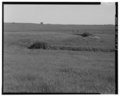
Looking northeast from south end of project; ditch dry - Natomas Ditch System, Blue Ravine Segment, Juncture of Blue Ravine and Green Valley Roads, Folsom, Sacramento County, HAER CAL,37-FOLSO.V,1A-12.tif
5,000 × 4,023; 19.19 MB
LOOKING SOUTHEAST UP A GULLY DEEPENED BY TERMINAL WATER FROM NORTH BRANCH, PRAIRIE CITY DITCH. - Natomas Ditch System, Rhodes Ditch, West of Bidwell Street, north of U.S. HAER CAL,3-FOLSO.V,1B-24.tif
5,000 × 4,009; 19.12 MB
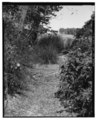
Looking southwest down long straight run of ditch - Natomas Ditch System, Blue Ravine Segment, Juncture of Blue Ravine and Green Valley Roads, Folsom, Sacramento County, CA HAER CAL,37-FOLSO.V,1A-11.tif
5,000 × 4,052; 19.32 MB
NORTH BRANCH, PRAIRIE CITY DITCH, CONTOURING AROUND SIDE OF KNOLL. DITCH LIES BETWEEN OAK TREE AND POINTED ROCKS, AND EXITS PHOTOGRAPH AT LOWER RIGHT CORNER. VIEW TO NORTHEAST HAER CAL,3-FOLSO.V,1B-22.tif
3,999 × 5,000; 19.07 MB
OVERVIEW OF CENTRAL PROJECT AREA, LOOKING SOUTHWEST TOWARD U.S. HIGHWAY 50. - Natomas Ditch System, Rhodes Ditch, West of Bidwell Street, north of U.S. Highway 50, Folsom, HAER CAL,3-FOLSO.V,1B-11.tif
5,000 × 4,014; 19.14 MB
OVERVIEW TO EAST-NORTHEAST ACROSS VALLEY CONTAINING RHODES DITCH. - Natomas Ditch System, Rhodes Ditch, West of Bidwell Street, north of U.S. Highway 50, Folsom, Sacramento HAER CAL,3-FOLSO.V,1B-13.tif
5,000 × 4,002; 19.09 MB
OVERVIEW TO WEST. RHODES DITCH RUNS ACROSS PHOTO TO THIS SIDE OF SCATTERED OAKS IN DISTANCE. - Natomas Ditch System, Rhodes Ditch, West of Bidwell Street, north of U.S. HAER CAL,3-FOLSO.V,1B-12.tif
5,000 × 4,037; 19.25 MB
Pastures and landscape context; ditch runs along line of oaks in distance - Natomas Ditch System, Blue Ravine Segment, Juncture of Blue Ravine and Green Valley Roads, Folsom, HAER CAL,37-FOLSO.V,1A-5.tif
5,000 × 4,028; 19.21 MB
PRAIRIE CITY DITCH, NEAR ITS JUNCTION WITH RHODES DITCH, CUT THROUGH SLATY BEDROCK. VIEW TO NORTHEAST. - Natomas Ditch System, Rhodes Ditch, West of Bidwell Street, north of U HAER CAL,3-FOLSO.V,1B-17.tif
5,000 × 4,027; 19.2 MB
RHODES DITCH NEAR BIDWELL STREET AT NORTHEAST PART OF PROJECT. VIEW TO NORTH. - Natomas Ditch System, Rhodes Ditch, West of Bidwell Street, north of U.S. Highway 50, Folsom, HAER CAL,3-FOLSO.V,1B-6.tif
5,000 × 4,003; 19.09 MB
RHODES DITCH, UPPER LEFT TO LOWER RIGHT, AT JUNCTION WITH PRAIRIE CITY DITCH, HEADING TO UPPER RIGHT. VIEW TO SOUTH. - Natomas Ditch System, Rhodes Ditch, West of Bidwell HAER CAL,3-FOLSO.V,1B-16.tif
5,000 × 4,017; 19.16 MB
RHODES DITCH- VIEW TO SOUTHEAST, SHOWING SHARP 'U' CONTOURED ABOVE SWALE. DITCH IS ALSO VISIBLE IN DISTANCE, RUNNING HORIZONTALLY ACROSS PHOTO, ON FAR HILLSIDE. - Natomas Ditch HAER CAL,3-FOLSO.V,1B-8.tif
4,039 × 5,000; 19.26 MB
ROCK CORE BERM AT ANGLE OF DITCH. U.S. HIGHWAY 50 IN BACKGROUND. - Natomas Ditch System, Rhodes Ditch, West of Bidwell Street, north of U.S. Highway 50, Folsom, Sacramento HAER CAL,3-FOLSO.V,1B-15.tif
5,000 × 4,042; 19.28 MB
ROLLING LANDSCAPE, CATTLE, AND RHODES DITCH IN FOREGROUND. VIEW TO SOUTHWEST. - Natomas Ditch System, Rhodes Ditch, West of Bidwell Street, north of U.S. Highway 50, Folsom, HAER CAL,3-FOLSO.V,1B-3.tif
5,000 × 4,008; 19.11 MB
SHARP 'V' IN NORTH BRANCH PRAIRIE CITY DITCH. VIEW TO NORTHWEST. - Natomas Ditch System, Rhodes Ditch, West of Bidwell Street, north of U.S. Highway 50, Folsom, Sacramento HAER CAL,3-FOLSO.V,1B-19.tif
5,000 × 4,004; 19.1 MB
SHARP ANGLE IN DITCH. VIEW TO NORTHWEST. - Natomas Ditch System, Rhodes Ditch, West of Bidwell Street, north of U.S. Highway 50, Folsom, Sacramento County, CA HAER CAL,3-FOLSO.V,1B-9.tif
5,000 × 4,054; 19.33 MB
SHARP CURVES IN RHODES DITCH NEAR NORTHEAST PART OF PROJECT. VIEW TO SOUTHEAST. - Natomas Ditch System, Rhodes Ditch, West of Bidwell Street, north of U.S. Highway 50, Folsom, HAER CAL,3-FOLSO.V,1B-7.tif
4,017 × 5,000; 19.16 MB
SINUOUS EARTH BERMS ALONG CONTOUR LINE. VIEW TO NORTHWEST. - Natomas Ditch System, Rhodes Ditch, West of Bidwell Street, north of U.S. Highway 50, Folsom, Sacramento County, HAER CAL,3-FOLSO.V,1B-10.tif
5,000 × 4,042; 19.28 MB
SOUTH BRANCH, PRAIRIE CITY DITCH, RUNNING SOUTHWEST UNDER FENCE, TOWARD US HWY. 50 IN DISTANCE. - Natomas Ditch System, Rhodes Ditch, West of Bidwell Street, north of U.S. HAER CAL,3-FOLSO.V,1B-18.tif
4,038 × 5,000; 19.26 MB
TERMINUS, NORTH BRANCH PRAIRIE CITY DITCH. DITCH COMES FROM ISOLATED GROUP OF TREES IN MIDDLE DISTANCE, AND ENDS AT CENTER RIGHT. WATER THEN PROCEEDED DOWN SWALE, INTO TREES HAER CAL,3-FOLSO.V,1B-23.tif
5,000 × 4,068; 19.4 MB
TIGHT S-SHAPED CURVES ALONG CONTOUR LINE. VIEW TO SOUTHEAST. - Natomas Ditch System, Rhodes Ditch, West of Bidwell Street, north of U.S. Highway 50, Folsom, Sacramento County, HAER CAL,3-FOLSO.V,1B-5.tif
5,000 × 4,014; 19.14 MB
View of dry ditch to north at juncture main canal and cement siphon pipe - Natomas Ditch System, Blue Ravine Segment, Juncture of Blue Ravine and Green Valley Roads, Folsom, HAER CAL,37-FOLSO.V,1A-1.tif
4,047 × 5,000; 19.3 MB
View to northeast from near siphon structure showing broad, U-shaped earthen banked ditch - Natomas Ditch System, Blue Ravine Segment, Juncture of Blue Ravine and Green HAER CAL,37-FOLSO.V,1A-10.tif
5,000 × 4,019; 19.17 MB
VIEW TO SOUTHEAST ALONG NORTH BRANCH, PRAIRIE CITY DITCH, TOWARD SHARP 'V' OF VIEW 18. - Natomas Ditch System, Rhodes Ditch, West of Bidwell Street, north of U.S. Highway 50, HAER CAL,3-FOLSO.V,1B-20.tif
4,012 × 5,000; 19.13 MB
Water control structure and water-filled ditch at north end of project - Natomas Ditch System, Blue Ravine Segment, Juncture of Blue Ravine and Green Valley Roads, Folsom, HAER CAL,37-FOLSO.V,1A-14.tif
4,034 × 5,000; 19.24 MB
WET SPOT NEAR NORTH PROJECT BOUNDARY, WHERE RHODES DITCH RECEIVES WATER FROM A NATURAL DRAINAGE. VIEW TO SOUTH. - Natomas Ditch System, Rhodes Ditch, West of Bidwell Street, HAER CAL,3-FOLSO.V,1B-1.tif
5,000 × 4,018; 19.16 MB
Category
:
Folsom, California
Navigation menu
Personal tools
English
Not logged in
Talk
Contributions
Create account
Log in
Namespaces
Category
Discussion
English
Views
View
Edit
History
More
Search
Navigate
Main page
Welcome
Community portal
Village pump
Help center
Participate
Upload file
Recent changes
Latest files
Random file
Contact us
Tools
What links here
Related changes
Special pages
Permanent link
Page information
Get shortened URL
Download QR code
Print/export
Create a book
Download as PDF
Printable version
In Wikipedia
Add links