Category:National Cycle Network route 3
Jump to navigation
Jump to search

Cycle route in the United Kingdom   | |||||
| Upload media | |||||
| Instance of | |||||
|---|---|---|---|---|---|
| Part of | |||||
| Location |
| ||||
| |||||
Media in category "National Cycle Network route 3"
The following 40 files are in this category, out of 40 total.
-
 Bridgwater - Taunton canal at Charlton - geograph.org.uk - 94152.jpg 640 × 412; 73 KB
-
 Bridgwater and Taunton Canal - geograph.org.uk - 114544.jpg 640 × 480; 94 KB
-
 Bridgwater and Taunton Canal - geograph.org.uk - 243815.jpg 640 × 480; 99 KB
-

-

-
 Bridgwater and Taunton Canal.jpg 5,152 × 3,864; 4.38 MB
-
 Bridgwater-Taunton canal at Charlton - geograph.org.uk - 1608929.jpg 640 × 480; 101 KB
-
 Cycle Path - NCN 3 - geograph.org.uk - 379845.jpg 480 × 640; 115 KB
-
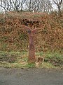
 Cycle route marker - geograph.org.uk - 1595896.jpg 480 × 640; 145 KB
-

-
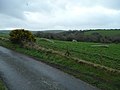
 Field by the cycle trail - geograph.org.uk - 1390063.jpg 640 × 480; 95 KB
-
 Former railway line at Stockwood - geograph.org.uk - 179873.jpg 640 × 480; 143 KB
-
-
 Long Holcombe on Exmoor - geograph.org.uk - 47201.jpg 602 × 400; 44 KB
-
 Milepost at Mayon Cliff - geograph.org.uk - 43514.jpg 427 × 640; 139 KB
-
 Milepost on National Cycle Network 3 near Bratton Fleming.jpg 427 × 640; 365 KB
-
 Mille Millennium Milepost on NCN3 at Hayle- panoramio.jpg 2,056 × 3,648; 5.06 MB
-
 National Cycle Network Route 3 milepost, East Hill, St Austell, Cornwall - November 2022.jpg 3,456 × 4,608; 5.22 MB
-
 National Cycle Network Sign Post - geograph.org.uk - 129287.jpg 640 × 426; 53 KB
-
 National Cycle Network signpost. - geograph.org.uk - 1203064.jpg 426 × 640; 108 KB
-
 National Cycle Network, Route 3 milepost - geograph.org.uk - 484704.jpg 480 × 640; 129 KB
-
 National Cycle Route 3 - geograph.org.uk - 2159380.jpg 1,024 × 681; 288 KB
-
 National Cycle Route 3 - geograph.org.uk - 4238848.jpg 640 × 480; 104 KB
-

-

-

-
 National Cycle Route 3, near Trelissick - geograph.org.uk - 2159392.jpg 1,024 × 681; 315 KB
-
 NCN Route 3.svg 512 × 512; 991 bytes
-
 NCN Route Sign 3.svg 372 × 172; 5 KB
-
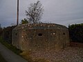 Pillbox southwest of Charlton, Somerset.jpg 5,152 × 3,864; 4.41 MB
-
 Road bridge over cycleway nr. Heligan - geograph.org.uk - 493327.jpg 640 × 480; 153 KB
-
 Saltford - junction of cycle routes - geograph.org.uk - 47265.jpg 578 × 380; 93 KB
-
 Sign Post in Woolard - geograph.org.uk - 1120750.jpg 406 × 640; 122 KB
-
 St Erth junction on A30, Rose-an-Grouse, Cornwall - June 2024.jpg 3,870 × 2,723; 1.56 MB
-
 Stone outcrops near Roseney Farm - geograph.org.uk - 686476.jpg 640 × 480; 60 KB
-
 Tarka Trail, Lambert Moor - geograph.org.uk - 71788.jpg 480 × 640; 75 KB
-

-

-
 Totterdown Bridge - geograph.org.uk - 742966.jpg 640 × 480; 116 KB
-
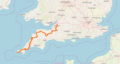 UK National Cycle Route 3.png 861 × 457; 249 KB


