Category:Nantmawr
Jump to navigation
Jump to search
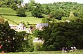
Cymraeg: Pentref yn Swydd Amwythig, Lloegr, yw Nantmawr. Mae'n gorwedd tua 5 milltir i'r de-orllewin o dref Croesoswallt yn agos i'r ffin â Chymru. Rhed Llwybr Clawdd Offa trwy'r pentref.
English: Nantmawr is a village in Shropshire, England. It is located about 8 km south west of Oswestry and close to the Welsh border. The Offa's Dyke Path runs through the village.
village in Shropshire, United Kingdom  | |||||
| Upload media | |||||
| Instance of | |||||
|---|---|---|---|---|---|
| Location | Llanyblodwel, Shropshire, West Midlands, England | ||||
 | |||||
Media in category "Nantmawr"
The following 13 files are in this category, out of 13 total.
-
 Approaching Nantmawr - geograph.org.uk - 710592.jpg 637 × 419; 83 KB
-
 Bridge at Nantmawr.jpg 4,000 × 3,000; 5.24 MB
-
 Bridge entering Nantmawr from the west.jpg 640 × 446; 83 KB
-
 Country West of Nantmawr - geograph.org.uk - 910309.jpg 640 × 480; 94 KB
-
 Entering Nantmawr - geograph.org.uk - 902519.jpg 640 × 480; 95 KB
-

-
 Lane Bifurcation near Nantmawr - geograph.org.uk - 910319.jpg 640 × 480; 84 KB
-
 Lane towards Jones' Rough - geograph.org.uk - 902548.jpg 640 × 480; 119 KB
-
 Path to Nantmawr - geograph.org.uk - 902496.jpg 640 × 480; 106 KB
-
 View west down hill into Nantmawr - geograph.org.uk - 1722547.jpg 640 × 480; 82 KB
-
 Wesleyan Chapel at Nantmawr - geograph.org.uk - 548832.jpg 640 × 480; 91 KB
-
 Cottage in the valley at Nantmawr - geograph.org.uk - 548852.jpg 640 × 480; 138 KB
-
 Hill above Nantmawr - geograph.org.uk - 548839.jpg 640 × 480; 119 KB


