Category:Naens
Jump to navigation
Jump to search
| Object location | | View all coordinates using: OpenStreetMap |
|---|
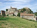
human settlement in Senterada, Pallars Jussà, Alt Pirineu i Aran, Spain  El poble des de ponent | |||||
| Upload media | |||||
| Instance of |
| ||||
|---|---|---|---|---|---|
| Location | Senterada, Pallars Jussà, Lleida Province, Catalonia | ||||
| Population |
| ||||
| Elevation above sea level |
| ||||
 | |||||
Català: Naens, nucli del municipi de Senterada (Pallars Jussà)
Subcategories
This category has the following 2 subcategories, out of 2 total.
S
- Sant Esteve de Naens (1 F)
- Sant Miquel de Naens (3 F)
Media in category "Naens"
The following 2 files are in this category, out of 2 total.
-
 Senterada. Naens 18.JPG 2,592 × 1,944; 1.25 MB
-
 Senterada. Naens 5.JPG 2,592 × 1,944; 1.25 MB
