Category:Nachterstedt
Jump to navigation
Jump to search
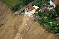
Deutsch: Nachterstedt war bis zum Jahre 1990 ein Zentrum des Braunkohlenbergbaus. Hierzu musste der Ort nach Süden verlegt werden. Aus dem Tagebaurestloch entstand der Concordiasee.
Der nördlichste Teil Nachterstedts musste aufgegeben werden, da es am Concordiasee 2009 zu einem großen Böschungsabbruch kam.
neighborhood in Seeland, Germany   .svg) | |||||
| Upload media | |||||
| Instance of | |||||
|---|---|---|---|---|---|
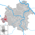
| Location | Seeland, Salzlandkreis, Saxony-Anhalt, Germany | ||||
| Population |
| ||||
| Area |
| ||||
| Elevation above sea level |
| ||||
 | |||||
Subcategories
This category has the following 5 subcategories, out of 5 total.
B
- Bahnhof Nachterstedt (6 F)
F
- Friedhof Nachterstedt (5 F)
K
- Kulturhaus Nachterstedt (5 F)
R
- Rathaus Nachterstedt (7 F)
S
Media in category "Nachterstedt"
The following 48 files are in this category, out of 48 total.
-
 Am Bahnhof 1 (Nachterstedt).jpg 5,184 × 3,888; 8.52 MB
-
 Am Bahnhof 4 (Nachterstedt) 01.jpg 5,184 × 3,888; 9.01 MB
-
 Am Bahnhof 4 (Nachterstedt) 02.jpg 5,184 × 3,888; 9.03 MB
-
 Autumn - panoramio (75).jpg 3,000 × 4,000; 5.26 MB
-
 Bahnhofstraße (Nachterstedt) Richtung Concordiasee.jpg 5,184 × 3,888; 9.33 MB
-
 Bundesarchiv Bild 183-2005-0721-525, Dorfumsiedlung nach Kohlefund.jpg 796 × 475; 103 KB
-
 Concordiasee Unglucksort2012.JPG 5,184 × 3,456; 7.89 MB
-
 Haldenstraße 15-22 (Nachterstedt).jpg 5,184 × 3,888; 8.54 MB
-
 Haldenstraße 23-25 (Nachterstedt).jpg 5,184 × 3,888; 7.66 MB
-
 Haldenstraße 24 (Nachterstedt) Eingang.jpg 5,184 × 3,888; 8.27 MB
-
 Helbra, Bergarbeiterverein Nachterstedt.JPG 1,701 × 2,551; 1.22 MB
-
 Hoymer Straße (Nachterstedt).jpg 5,184 × 3,888; 9.21 MB
-
 Lindenstraße (Nachterstedt) Denkmal 01.jpg 5,184 × 3,888; 7.64 MB
-
 Lindenstraße (Nachterstedt) Denkmal 02.jpg 5,184 × 3,888; 8.84 MB
-
 Lindenstraße (Nachterstedt) Denkmal 03.jpg 5,184 × 3,888; 8.78 MB
-
 Lindenstraße 36 (Nachterstedt).jpg 5,184 × 3,888; 9.13 MB
-
 Lindenstraße 77 (Nachterstedt) Glück-auf-Apotheke.jpg 4,591 × 3,563; 5.55 MB
-
 Lokomotive in Nachterstedt (2321565546).jpg 1,152 × 768; 160 KB
-
 Nachterstedt (Seeland), the Lindenstraße.jpg 2,622 × 1,657; 1.22 MB
-
 Nachterstedt 001.JPG 4,032 × 2,272; 5.21 MB
-
 Nachterstedt in Seeland (Sachsen-Anhalt).svg 818 × 887; 73 KB
-
 Nachterstedt in SLK.png 299 × 299; 9 KB
-
 NACHTERSTEDT nieder.svg 512 × 427; 21 KB
-
 Novelis Nachterstedt 01.jpg 5,184 × 3,888; 8.71 MB
-
 Novelis Nachterstedt 02.jpg 5,184 × 3,888; 8.64 MB
-
 Novelis Nachterstedt 03.jpg 5,184 × 3,888; 7.8 MB
-
 Novelis Nachterstedt 04.jpg 5,184 × 3,888; 7.97 MB
-
 Pegel Concordia-See 01.jpg 3,888 × 5,184; 7.9 MB
-
 Pegel Concordia-See 02.jpg 3,888 × 5,184; 6.85 MB
-
 Schulstraße 15 (Nachterstedt) Grundschule und Seelandschule.jpg 5,184 × 3,888; 7.62 MB
-
 Schulstraße 15 (Nachterstedt) Grundschule.jpg 5,184 × 3,888; 7.46 MB
-
 Schulstraße 15 (Nachterstedt) Schulen.jpg 5,184 × 3,888; 8.13 MB
-
 Schulstraße 15 (Nachterstedt) Seelandschule.jpg 5,184 × 3,888; 9.09 MB
-
 Siegelmarke Gemeinde Nachterstedt W0327976.jpg 270 × 270; 15 KB
-
 Strommasten A36 2020-05-02 2.jpg 3,648 × 2,736; 2.13 MB
-
 Tagebau Nachterstedt.jpg 2,783 × 1,484; 2.23 MB
-
 Tagebaurestloch.jpg 900 × 467; 66 KB
-
 Thomas-Müntzer-Straße 17 (Nachterstedt) 01.jpg 5,588 × 3,940; 13.08 MB
-
 Thomas-Müntzer-Straße 17 (Nachterstedt) 02.jpg 5,636 × 3,964; 13.1 MB
-
 Thomas-Müntzer-Straße 17 (Nachterstedt) 04.jpg 5,472 × 3,968; 14.38 MB
-
 Unglück von Nachterstedt File 00017DA4.jpg 500 × 332; 35 KB
-
 UnglückNachterstedt (cropped).JPG 912 × 510; 475 KB
-
 UnglückNachterstedt.JPG 2,231 × 1,371; 2.28 MB
-
 Virchowstraße 8 Thomas-Müntzer-Straße 17 (Nachterstedt).jpg 5,792 × 3,960; 13.41 MB
-
 Virchowstraße 8a (Nachterstedt) 02.jpg 6,000 × 4,000; 5.61 MB
-
 Virchowstraße 8a (Nachterstedt) 03.jpg 5,784 × 3,976; 12.59 MB
-
 Wappen nachterstedt.png 165 × 198; 22 KB
-
 Wappen Nachterstedt.png 590 × 660; 84 KB
.jpg)
_01.jpg)
_02.jpg)
.jpg)
_Richtung_Concordiasee.jpg)


.jpg)
.jpg)
_Eingang.jpg)

.jpg)
_Denkmal_01.jpg)
_Denkmal_02.jpg)
_Denkmal_03.jpg)
.jpg)
_Gl%C3%BCck-auf-Apotheke.jpg)
.jpg)
,_the_Lindenstra%C3%9Fe.jpg)


_Grundschule_und_Seelandschule.jpg)
_Grundschule.jpg)
_Schulen.jpg)
_Seelandschule.jpg)


_01.jpg)
_02.jpg)
_04.jpg)

.JPG)

.jpg)
_02.jpg)
_03.jpg)
