Category:NASA MODIS images of Africa
Jump to navigation
Jump to search
Subcategories
This category has the following 2 subcategories, out of 2 total.
P
Media in category "NASA MODIS images of Africa"
The following 97 files are in this category, out of 97 total.
-
 AERONET Izana.2011288.aqua (detalle).250m.jpg 601 × 454; 57 KB
-
 AFAR-MODIS.jpg 1,400 × 1,800; 355 KB
-
 Algeria 29aug02 500m 367.jpg 2,000 × 2,000; 688 KB
-
 Algeria.A2002118.1040.250m.jpg 4,400 × 5,800; 2.01 MB
-
 Angola may 11 2001 0920Z.jpg 4,800 × 3,600; 2.3 MB
-
 Atlantic tmo 2012177 lrg.jpg 6,800 × 8,800; 9.56 MB
-
 Bodele Depression Dust Storm - NASA Earth Observatory.jpg 720 × 480; 69 KB
-
 Canarias NASA2.jpg 1,024 × 714; 100 KB
-
 Canary A2002186 1155 250m.jpg 3,400 × 4,400; 1.89 MB
-
 Cape Verde, Kármán vortex street.jpg 2,428 × 1,619; 3.46 MB
-
 Chad AMO 2004323 lrg.jpg 3,400 × 2,600; 1.1 MB
-
 Composite satellite image of South Africa ,Eswatini and Lesotho.jpg 6,533 × 5,760; 5.27 MB
-
 Dust and Hydrogen Sulfide along the Namibian Coast.jpg 2,600 × 3,400; 729 KB
-
 Dust Atmospheric wave Sep 23 2011 1200(UTC).jpg 4,187 × 2,725; 1.41 MB
-
 Dust off Western Africa - NASA Earth Observatory.jpg 720 × 720; 119 KB
-
 Dust over the Atlantic Ocean - NASA Earth Observatory.jpg 720 × 720; 126 KB
-
 Dust over the Red Sea 2010-02-26 lrg.jpg 3,600 × 4,800; 2.59 MB
-
 Dust Plume off Mauritania.jpg 2,800 × 3,600; 696 KB
-
 Dust Plumes off Western Africa.jpg 5,600 × 7,200; 3.24 MB
-
 Dust Storm in the Bodele Depression, Chad, Natural Hazards DVIDS761449.jpg 4,400 × 5,800; 2.23 MB
-
 Dust Storm near Lake Chad, Image of the Day DVIDS844465.jpg 2,000 × 1,500; 632 KB
-
 Dust storm over Libya.jpg 2,000 × 1,556; 839 KB
-
 Dust Storms from Africa's Bodele Depression, Natural Hazards DVIDS848674.jpg 2,000 × 1,500; 348 KB
-
 Dust Storms from Africa's Bodele Depression, Natural Hazards DVIDS852942.jpg 3,400 × 2,600; 1.03 MB
-
 Eclipse EastAfrica AMO 20051003.jpg 540 × 675; 126 KB
-
 Egypt (5635018418).jpg 3,840 × 2,880; 2.18 MB
-
 Egypt New Valley Project 26jan2003.jpg 450 × 364; 5 KB
-
 Egypt.A2010286.0845.250m.jpg 3,400 × 4,400; 1.65 MB
-
 El Hierro eruption MODIS 20111013.jpg 434 × 278; 67 KB
-
 El Hierro eruption MODIS 20111023.jpg 872 × 764; 231 KB
-
 El Hierro Submarine Eruption - NASA Earth Observatory.jpg 720 × 480; 141 KB
-
 Fires in West Africa - November 7, 2013.jpg 4,400 × 3,400; 2.62 MB
-
 Flooding in Mozambique Púnguè River 2010-03-08 lrg.jpg 4,552 × 3,640; 4.45 MB
-
 Flooding in Mozambique Púnguè River 2010-03-08.jpg 720 × 360; 126 KB
-
 Gambia satellite fires.jpeg 1,432 × 433; 103 KB
-
 Great Escarpment, South Africa.jpg 5,600 × 4,000; 3.36 MB
-
 Hydrogen Sulfide Emissions along the Namibian Coast 2010-03-13 lrg.jpg 1,600 × 2,000; 552 KB
-
 Hydrogen Sulfide Emissions along the Namibian Coast 2010-03-13.jpg 720 × 480; 32 KB
-

-
 Hydrogen Sulfide Emissions off of Africa.jpg 1,295 × 870; 449 KB
-
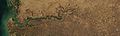
 Inland Niger Delta 2007.jpg 1,024 × 888; 167 KB
-
 Lake Kyoga (NASA).jpg 600 × 451; 440 KB
-
 Lake Nasser and Toshka Lakes, Egypt-cerclé.jpg 3,200 × 2,400; 693 KB
-
 Lake Nasser and Toshka Lakes, Egypt.jpg 3,200 × 2,400; 831 KB
-
 Libya.A2010271.0930.250m.jpg 1,800 × 2,200; 409 KB
-
-
 Madagascar change deforestation.jpg 540 × 425; 72 KB
-
 Madagascar change lrg deforestation.jpg 2,919 × 2,919; 1.99 MB
-
 Madagascar topo-ar.jpg 540 × 540; 128 KB
-
 Madagascar topo.jpg 540 × 540; 94 KB
-
 MODIS1000023 md.jpg 600 × 467; 95 KB
-
 Morokweng.jpg 500 × 500; 54 KB
-
 Nabro Volcano ash cloud 2011-06-13, Eritrea.jpg 6,000 × 4,400; 4.32 MB
-
 Namibia may 11 2001 0920Z.jpg 3,600 × 4,800; 1.81 MB
-
 Namibia’s Protected Coast.jpg 4,000 × 5,600; 4.27 MB
-
 Namibië satelliet.jpg 1,800 × 2,400; 537 KB
-
 Nigeria (4691436560).jpg 4,000 × 3,000; 1,016 KB
-
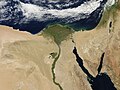
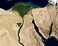 Nile River and delta from orbit.jpg 700 × 550; 85 KB
-
 Redsea sandstorm May13-2005.jpg 5,600 × 4,400; 2.43 MB
-
 RedSea.A2004273.1050.250m.jpg 6,400 × 8,400; 6.69 MB
-
 Saharan dust - Jun 18, 2020.jpg 4,532 × 3,233; 1.66 MB
-
 Sand above East Mediterrean Sea.jpg 5,600 × 4,400; 4.51 MB
-
 Sand Sea in Southwestern Libya - NASA Earth Observatory.jpg 720 × 480; 100 KB
-
 Satellite image of Botswana in December 2003.jpg 4,378 × 4,194; 2.69 MB
-
 Satellite image of Burkina Faso in November 2002.jpg 3,524 × 2,591; 1.11 MB
-
 Satellite image of Burundi in February 2003.jpg 845 × 980; 122 KB
-
 Satellite image of Cape Verde in December 2002.jpg 1,189 × 1,111; 485 KB
-
 Satellite image of Central African Republic in February 2004.jpg 6,900 × 4,433; 2.81 MB
-
 Satellite image of Comoros in April 2002.jpg 609 × 533; 47 KB
-
 Satellite image of Djibouti in November 2001.jpg 744 × 820; 100 KB
-
 Satellite image of Eritrea in May 2003.jpg 2,964 × 2,564; 910 KB
-
 Satellite image of Gambia in April 2002.jpg 1,308 × 496; 56 KB
-
 Satellite image of Guinea in February 2003.jpg 3,320 × 2,486; 1.04 MB
-
 Satellite image of Guinea-Bissau in January 2003.jpg 1,361 × 833; 169 KB
-
 Satellite image of Lesotho in May 2002.jpg 965 × 944; 171 KB
-
 Satellite image of Liberia in January 2003.jpg 1,861 × 1,949; 311 KB
-
 Satellite image of Madagascar in September 2003.jpg 3,214 × 6,164; 2.94 MB
-
 Satellite image of Malawi in June 2003.jpg 1,467 × 3,513; 695 KB
-
 Satellite image of Mauritius in February 2003.jpg 247 × 287; 15 KB
-
 Satellite image of Morocco in January 2002.jpg 4,732 × 3,727; 2.59 MB
-
 Satellite image of Mozambique in September 2002.jpg 4,977 × 6,715; 4.45 MB
-
 Senegal satellite fires.jpeg 2,897 × 2,090; 780 KB
-
 Snow in the Atlas Mountains of Morocco - NASA Earth Observatory.jpg 720 × 724; 207 KB
-
 Socotra Archipelago MODIS.jpg 1,000 × 604; 145 KB
-
 Sofala Province Mozambique 2009-03-12 lrg.jpg 4,552 × 3,640; 3.97 MB
-
 Sofala Province Mozambique 2009-03-12.jpg 720 × 360; 128 KB
-
 Solar eclipse over western Africa (morning overpass) - November 3, 2013.jpg 11,200 × 9,000; 21.56 MB
-
 South Africa-NLT Landsat7.png 1,022 × 724; 1.07 MB
-
 Sudan Lake Nubia 26jan2003.jpg 562 × 458; 21 KB
-
 Sudan Nile River 17oct2001.jpg 3,400 × 4,400; 1.72 MB
-
 Tropical Cyclone Three (03A) off Somalia - November 8, 2013.jpg 5,297 × 7,121; 3.9 MB
-
 Waterberg Sat.jpg 400 × 300; 27 KB
-
 West Africa may 8 2001 1200Z.jpg 4,000 × 3,000; 1.16 MB
-
 Windy Weather Carries Dust over Egypt and Saudi Arabia 2010-02-26 lrg.jpg 3,600 × 2,800; 1,013 KB
-
 Windy Weather Carries Dust over Egypt and Saudi Arabia 2010-02-26.jpg 720 × 480; 233 KB
-
 Zambezi Flood Plain, Namibia (MODIS).jpg 4,552 × 3,640; 3.02 MB
-
 Zuid-Afrika satelliet.jpg 2,145 × 1,660; 971 KB
.250m.jpg)


.jpg)


.jpg)


.jpg)


.jpg)


.jpg)


_-_November_3,_2013.jpg)


_off_Somalia_-_November_8,_2013.jpg)


.jpg)
