Category:NARA images of San Bernardino County, California
Jump to navigation
Jump to search
English: Images from NARA—the National Archives and Records Administration — of San Bernardino County, California from the 19th and 20th centuries.
- Includes images from the Environmental Protection Agency's NARA Program to photographically document subjects of Environmental Concern, compiled 1972—1977.
Media in category "NARA images of San Bernardino County, California"
The following 56 files are in this category, out of 56 total.
-

-

-

-

-

-
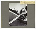 Aircraft and Airports - California - DPLA - d0170fc324b1e2927cb4173d8e46f073.jpg 6,169 × 4,939; 3.47 MB
-

-
-

-

-

-
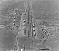
 Atlantic Pacific Railroad through San Bernadino County, California - NARA - 102256234.jpg 6,966 × 5,154; 4.43 MB
-
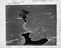
 California - Angle Island through Arrowhead Lake - NARA - 23934071.jpg 3,192 × 2,536; 4.82 MB
-
 California - Baldwin Lake - NARA - 23934087.jpg 3,192 × 2,505; 4.92 MB
-
 California - Baldwin Lake - NARA - 23934089.jpg 3,192 × 2,536; 4.91 MB
-
 California - Barstow through Benicia - NARA - 23934091.jpg 5,661 × 7,427; 22.21 MB
-
 California - Beverly Hills through Big Bear Lake - NARA - 23934137.jpg 5,290 × 4,242; 6.29 MB
-
 California - Beverly Hills through Big Bear Lake - NARA - 23934139.jpg 5,334 × 4,242; 5.92 MB
-
 California - Beverly Hills through Big Bear Lake - NARA - 23934141.jpg 5,217 × 4,242; 5.52 MB
-
 California - Cajon Pass - NARA - 23934163.jpg 7,159 × 5,929; 11.43 MB
-
 California - Cajon Pass - NARA - 23934165.jpg 7,437 × 5,929; 8.71 MB
-
 California - Cajon Pass - NARA - 23934167.jpg 5,364 × 4,235; 4.14 MB
-
 California - Calico Mines - NARA - 23934169 (cropped).jpg 3,597 × 4,624; 7.21 MB
-
 California - Calico Mines - NARA - 23934169.jpg 4,235 × 5,364; 10.8 MB
-
 California - Calico Mines - NARA - 23934171.jpg 5,474 × 4,235; 4.45 MB
-
 California - Fontana through Freda - NARA - 23934331 (cropped).jpg 3,314 × 2,833; 5.08 MB
-
 California - Fontana through Freda - NARA - 23934331.jpg 4,378 × 3,440; 7.87 MB
-
 California - Golden State through High Head Reservoir - NARA - 23934359.jpg 3,379 × 4,376; 7.52 MB
-
 California - Golden State through High Head Reservoir - NARA - 23934361.jpg 4,397 × 3,424; 7.42 MB
-
 California - LaJolla through Lake Arrowhead - NARA - 23934415.jpg 4,459 × 3,400; 7.99 MB
-
 California - LaJolla through Lake Arrowhead - NARA - 23934417.jpg 4,459 × 3,400; 7.25 MB
-
 California - Lavic through Ubehebe Crater - NARA - 23935499.jpg 4,350 × 3,382; 4.45 MB
-
 California - Mt.San Gorgoino - NARA - 23935197.jpg 4,350 × 3,382; 2.35 MB
-
 California - Mt.San Gorgoino - NARA - 23935199.jpg 4,350 × 3,382; 2.08 MB
-
 California - Mt.San Gorgoino - NARA - 23935201.jpg 4,350 × 3,382; 2.55 MB
-
 California - Mt.San Gorgoino - NARA - 23935203.jpg 4,350 × 3,382; 3.57 MB
-
 California - Mt.San Gorgoino - NARA - 23935205.jpg 4,350 × 3,382; 1.55 MB
-
 California - Needles - NARA - 23934693.jpg 3,288 × 2,840; 2.1 MB
-
 California - Needles - NARA - 23934695.jpg 3,288 × 2,840; 1.94 MB
-
 California - Redlands - NARA - 23934957.jpg 4,438 × 3,382; 4.13 MB
-
 California - Redlands - NARA - 23934959.jpg 4,438 × 3,382; 3.81 MB
-
 California - Twenty-nine Palms through West Pittsburg - NARA - 23935405.jpg 4,350 × 3,382; 3.13 MB
-
 California - Victorville - NARA - 23935431.jpg 4,350 × 3,382; 2.85 MB
-
 California - Victorville - NARA - 23935433.jpg 4,350 × 3,382; 5.2 MB
-
 California - Victorville - NARA - 23935435.jpg 4,350 × 3,382; 2.28 MB
-
 California - Willows - NARA - 23935437.jpg 4,350 × 3,382; 4.3 MB
-
 California - Willows - NARA - 23935439.jpg 4,350 × 3,382; 2.38 MB
-
-

-
-
-
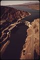 PARKER DAM ON THE COLORADO RIVER - NARA - 548936.jpg 2,021 × 3,000; 850 KB
-

-
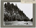 Shelterbelts- Windbreaks - California - DPLA - 1d9d3645cab55c9d3eebe5934cb8ecf2.jpg 4,783 × 3,804; 2.55 MB
-
 Shelterbelts- Windbreaks - California - DPLA - 58c95bcc796e457712f6fd83a108abc3.jpg 4,807 × 3,816; 2.19 MB
-


_aboard_a_UH-1_Iroquois_helicopter._The_paratrooper_was_injured_in_a_jump_from_a_C-130_Herc_-_DPLA_-_4c4860aa5a775ba185fe69140e975f5e.jpeg)

_Marv_-_DPLA_-_2ac63ea2645f4edec6ea98a63aec947c.jpeg)


_James_Barnad_(right),_63rd_Security_Police_Squadron,_runs_a_field_training_range_with_an_M16_rifle_to_refine_his_fighting_skills._A_scout_(left)_evaluates_h_-_DPLA_-_ae509c90bc78d27ca15316bb905cd888.jpeg)


_maneuver_down_range,_during_an_assault_on_the_Delta_Prospect_Range_at_the_Marine_Air_Ground_Task_Force_(MAGTF)_-_DPLA_-_aabf4e7856c836952c2722a97af7abb4.jpeg)


.jpg)


.jpg)


_helicopters_during_Exercise_GALLANT_EAGLE_%2786_-_DPLA_-_d953658fb9ec5bf0e9d2e98bc388d280.jpeg)


.gif)