Category:Nördliche Ringstraße 2 (Weißenburg in Bayern)
Jump to navigation
Jump to search
| Object location | | View all coordinates using: OpenStreetMap |
|---|
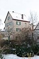
This is the category of the Bavarian Baudenkmal (cultural heritage monument) with the ID D-5-77-177-289 (Wikidata)
|
Deutsch: Weißenburg in Bayern - Nördliche Ringstraße 2 - Turm der Stadtbefestigung. Im 19. Jahrhundert ausgebaut zum Wohnhaus.
Media in category "Nördliche Ringstraße 2 (Weißenburg in Bayern)"
The following 4 files are in this category, out of 4 total.
-
 Weißenburg in Bayern - Nördliche Ringstraße 2 - 1.jpg 3,344 × 4,459; 6.9 MB
-
 Weißenburg, Nördliche Ringstraße 2-001.jpg 3,264 × 4,928; 8.55 MB
-
 Weißenburg, Nördliche Ringstraße 2-002.jpg 3,264 × 4,928; 8.57 MB
-
 Weißenburg, Nördliche Ringstraße 2-003.jpg 3,264 × 4,928; 7.86 MB


