Category:Näsbyparks kyrka
Jump to navigation
Jump to search
| Object location | | View all coordinates using: OpenStreetMap |
|---|
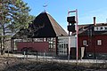
church building in Täby Municipality, Stockholm County, Sweden  | |||||
| Upload media | |||||
| Instance of | |||||
|---|---|---|---|---|---|
| Location | Täby Municipality, Stockholm County, Sweden | ||||
| Diocese | |||||
| Has use | |||||
| Occupant |
| ||||
| Heritage designation |
| ||||
| Inception |
| ||||
 | |||||
Svenska: Näsbyparks kyrka tillhör Täby församling, Roslags kontrakt, Stockholms stift / Diocese of Stockholm.
|
This is a category about an ecclesiastical monument in Sweden, number 21320000019176 (sub-number: 21420000014645) in the RAÄ buildings database.
|
Subcategories
This category has only the following subcategory.
I
- Interior of Näsbyparks kyrka (11 F)
Media in category "Näsbyparks kyrka"
The following 6 files are in this category, out of 6 total.
-
 NäsbyparkKyrka2101.jpg 5,184 × 3,456; 9.03 MB
-
 Näsbyparks kyrka 2014.jpg 3,888 × 2,592; 3.92 MB
-
 Näsbyparks kyrka klockstapel.jpg 1,894 × 3,427; 2.25 MB
-
 Näsbyparks kyrka nordöstra fasaden.jpg 3,472 × 2,736; 3.33 MB
-
 Näsbyparks kyrka skylt.jpg 2,836 × 801; 512 KB
-
 Näsbyparks kyrka.jpg 2,438 × 3,252; 2.39 MB


