Category:NÖ-Naturdenkmal HL-021 Lindengruppe Mariathal
Jump to navigation
Jump to search
| Object location | | View all coordinates using: OpenStreetMap |
|---|
 | |||||
| Upload media | |||||
| Instance of | |||||
|---|---|---|---|---|---|
| Location | Hollabrunn, Hollabrunn District, Lower Austria, Austria | ||||
| Street address |
| ||||
| Heritage designation | |||||
 | |||||

Media in category "NÖ-Naturdenkmal HL-021 Lindengruppe Mariathal"
The following 5 files are in this category, out of 5 total.
-
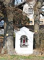
 GuentherZ 2012-03-24 0729 Mariathal Wegkapelle.jpg 1,800 × 1,129; 1.69 MB
-
 GuentherZ 2012-03-24 0730 Mariathal Wegkapelle.jpg 1,318 × 1,800; 1.92 MB
-
 Hollabrunn-Mariathal - ND HL-021 - Winterlinden (Tilia cordata) mit Marterl - 1.jpg 5,267 × 3,511; 8.81 MB
-
 Hollabrunn-Mariathal - ND HL-021 - Winterlinden (Tilia cordata) mit Marterl - 2.jpg 4,862 × 3,647; 9.01 MB
-
 Hollabrunn-Mariathal - ND HL-021 - Winterlinden (Tilia cordata) mit Marterl - 3.jpg 5,308 × 3,539; 10.38 MB

_mit_Marterl_-_1.jpg)
_mit_Marterl_-_2.jpg)
_mit_Marterl_-_3.jpg)