Category:Mulligan Highway
Jump to navigation
Jump to search
English: Mulligan Highway, Queensland
Formerly Cooktown Developmental Road
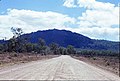
The Mulligan Highway is a state highway in Queensland, Australia. It runs for approximately 266 km between Mareeba and Cooktown, on the east coast of Cape York Peninsula where it terminates.
Named after bushman James Venture Mulligan the sealed highway follows the old Cooktown Developmental Road and was completed in 2006. Since it was sealed, travelling time from Cairns to Cooktown has reduced from 6 to 3½ hours.
Media in category "Mulligan Highway"
The following 43 files are in this category, out of 43 total.
-
 Black Mountain Mulligan Highway Cape York Peninsula 1986 IMG 0032.jpg 6,400 × 4,307; 12.53 MB
-
 Black Mountain Mulligan Highway Cape York Peninsula 1986 IMG 0042.jpg 4,253 × 6,608; 11.96 MB
-
 Black Mountain Mulligan Highway Cape York Peninsula 1986 IMG 0043.jpg 6,400 × 4,323; 21.67 MB
-
 Black Mountain Mulligan Highway Cape York Peninsula 1986 IMG 0044.jpg 6,374 × 4,258; 17.95 MB
-
 Black Mountain Mulligan Highway Cape York Peninsula 1986 IMG 0066.jpg 6,400 × 4,336; 13.93 MB
-
 Creek crossing Mulligan Highway Cape York Peninsula 1986 IMG 0031.jpg 6,416 × 4,330; 22.67 MB
-
 Creek crossing Mulligan Highway Cape York Peninsula 1986 IMG 0040.jpg 6,410 × 4,318; 19.65 MB
-
 Creek crossing Mulligan Highway Cape York Peninsula 1986 IMG.jpg 4,304 × 6,393; 20.55 MB
-
 Daintree ranges from Mulligan Highway Cape York Peninsula 1986 IMG 0005.jpg 6,384 × 4,336; 21.44 MB
-
 Daintree ranges from Mulligan Highway Cape York Peninsula 1986 IMG 0006.jpg 6,400 × 4,320; 16.1 MB
-
 Easter Grey Kangaroos - Flickr - GregTheBusker.jpg 3,072 × 2,304; 2.31 MB
-
 Great Dividing Range from Mulligan Highway Cape York Peninsula 1986 IMG 0057.jpg 6,337 × 4,265; 9.7 MB
-
 Great Dividing Range from Mulligan Highway Cape York Peninsula 1986 IMG 0058.jpg 6,070 × 3,600; 20.91 MB
-
 Great Dividing Range from Mulligan Highway Cape York Peninsula 1986 IMG 0059.jpg 6,384 × 4,336; 15.78 MB
-
 Great Dividing Range from Mulligan Highway Cape York Peninsula 1986 IMG 0066.jpg 6,384 × 4,336; 16.89 MB
-
 Great Dividing Range from Mulligan Highway Cape York Peninsula 1986 IMG 0067.jpg 6,337 × 4,281; 19.84 MB
-
 Great Dividing Range from Mulligan Highway Cape York Peninsula 1986 IMG 0068.jpg 6,374 × 4,325; 13.39 MB
-
 Lakeland Downs Mulligan Highway Cape York Peninsula 1986 IMG 0009.jpg 6,528 × 4,320; 13.97 MB
-
 Lascar "Blue, stars and tree" taken at Lake Mitchell (4560447888).jpg 2,592 × 1,944; 1.54 MB
-
 MountCarbine01.jpg 1,466 × 941; 330 KB
-
 On the Rocks - Flickr - GregTheBusker.jpg 3,072 × 2,304; 996 KB
-
 Staying Still 52 - Cape York Awesome.jpg 5,120 × 1,750; 9.82 MB
-
 View from Mulligan Highway Cape York Peninsula 1986 (2).jpg 6,384 × 4,336; 12.34 MB
-
 View from Mulligan Highway Cape York Peninsula 1986 IMG 0049.jpg 6,363 × 4,230; 18.53 MB
-
 View from Mulligan Highway Cape York Peninsula 1986 IMG 0057.jpg 6,400 × 4,352; 15.64 MB
-
 View from Mulligan Highway Cape York Peninsula 1986 IMG 0058.jpg 6,384 × 4,336; 12.77 MB
-
 View from Mulligan Highway Cape York Peninsula 1986 IMG 0061.jpg 6,384 × 4,368; 15.22 MB
-
 View from Mulligan Highway Cape York Peninsula 1986 IMG 0063.jpg 6,400 × 4,336; 16.12 MB
-
 View from Mulligan Highway Cape York Peninsula 1986 IMG 0064.jpg 6,400 × 4,320; 11.73 MB
-
 View from Mulligan Highway Cape York Peninsula 1986 IMG 0068.jpg 6,400 × 4,336; 13.13 MB
-
 View from Mulligan Highway Cape York Peninsula 1986 IMG 0069 (3).jpg 6,400 × 4,368; 15.03 MB
-
 View from Mulligan Highway Cape York Peninsula 1986 IMG 0072 (2).jpg 6,405 × 4,251; 21.16 MB
-
 View from Mulligan Highway Cape York Peninsula 1986 IMG 0073.jpg 6,400 × 4,336; 18.08 MB
-
 View from Mulligan Highway Cape York Peninsula 1986 IMG 0074 (2).jpg 6,384 × 4,336; 18.56 MB
-
 View from Mulligan Highway Cape York Peninsula 1986 IMG 0074.jpg 6,384 × 4,352; 13.89 MB
-
 View from Mulligan Highway Cape York Peninsula 1986 IMG 0076 (4).jpg 6,390 × 4,295; 16.93 MB
-
 View from Mulligan Highway Cape York Peninsula 1986 IMG 0077.jpg 6,400 × 4,336; 13.9 MB
-
 View from Mulligan Highway Cape York Peninsula 1986 IMG 0078.jpg 6,400 × 4,352; 13.75 MB
-
 View from Mulligan Highway Cape York Peninsula 1986 IMG 0079 (2).jpg 6,400 × 4,336; 12.08 MB
-
 View from Mulligan Highway Cape York Peninsula 1986 IMG 0084.jpg 6,384 × 4,352; 13.96 MB
-
 View from Mulligan Highway Cape York Peninsula 1986 IMG 0122.jpg 6,400 × 4,301; 16.39 MB
-
 Wild Mareeba Rock Wallaby Feeding - Flickr - GregTheBusker.jpg 3,072 × 2,304; 1.74 MB
-
 Yawning - Flickr - GregTheBusker.jpg 2,849 × 2,139; 1.46 MB


.jpg)


.jpg)


.jpg)
.jpg)

.jpg)

.jpg)


.jpg)


