Category:Muchalls
Jump to navigation
Jump to search
village in Aberdeenshire, Scotland, UK  | |||||
| Upload media | |||||
| Instance of | |||||
|---|---|---|---|---|---|
| Location |
| ||||
 | |||||
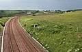
English: Muchalls is a small coastal ex- fishing village in Kincardineshire, Scotland, south of Newtonhill and north of Stonehaven. Muchalls is situated slightly north of a smaller hamlet known as the Bridge of Muchalls. At the western edge of Muchalls is the historic Saint Ternan's Church. The rugged North Sea coastline near Muchalls features numerous cliffs, sea stacks and headlands, not infrequently in haar. The Grim Brigs headland is situated at Muchalls southern edge and Doonie Point headland is approximately 1.5 kilometres south.
Media in category "Muchalls"
The following 46 files are in this category, out of 46 total.
-
 A fauna of the Tay Basin and Strathmore (1906) (14565197257).jpg 3,472 × 2,414; 696 KB
-
 A rock-scape from Grum Briggs - geograph.org.uk - 6668361.jpg 1,600 × 1,200; 550 KB
-
 A90 Near Muchalls - geograph.org.uk - 141570.jpg 640 × 475; 52 KB
-
 Arch at the end of an inlet at Grum Briggs - geograph.org.uk - 6668410.jpg 1,200 × 1,600; 469 KB
-
 Bridge and Mast at Monduff - geograph.org.uk - 1361520.jpg 454 × 640; 238 KB
-
 Bridge of Muchalls.jpg 640 × 485; 57 KB
-
 Cliff girt coast at Muchalls - geograph.org.uk - 4713030.jpg 800 × 570; 92 KB
-
 Cliffs at Muchalls - geograph.org.uk - 6279522.jpg 640 × 427; 311 KB
-

-
 Cottages in Muchalls - geograph.org.uk - 1454644.jpg 640 × 480; 89 KB
-
 Douniefell with west entrance to Ship Hole - geograph.org.uk - 6643758.jpg 1,024 × 1,024; 260 KB
-
 Heugh-head Cottages in Muchalls - geograph.org.uk - 1454674.jpg 640 × 480; 88 KB
-
 Limpet Mill - geograph.org.uk - 169513.jpg 640 × 480; 155 KB
-
 Looking through Ship Hole - geograph.org.uk - 6643776.jpg 1,024 × 1,024; 213 KB
-
 Looking towards Doonie point - geograph.org.uk - 375764.jpg 640 × 480; 78 KB
-
 Mains of Monduff - geograph.org.uk - 1454692.jpg 640 × 480; 74 KB
-
 Marine Terrace, Muchalls - geograph.org.uk - 1454655.jpg 640 × 480; 112 KB
-
 Muchalls - geograph.org.uk - 1294339.jpg 640 × 426; 51 KB
-
 Muchalls - geograph.org.uk - 1361515.jpg 640 × 427; 246 KB
-
 Ophelia's waterfall - geograph.org.uk - 6807773.jpg 1,200 × 1,600; 695 KB
-
 Railway Line at Muchalls - geograph.org.uk - 1361526.jpg 640 × 407; 247 KB
-
 Railway Viaduct, Muchalls - geograph.org.uk - 1454685.jpg 640 × 480; 80 KB
-
 Rocks at Grim Haven - geograph.org.uk - 4647517.jpg 640 × 480; 76 KB
-
 St Ternans Episcopal Church (geograph 4407317).jpg 640 × 427; 457 KB
-
 T-junction - geograph.org.uk - 365424.jpg 640 × 393; 41 KB
-
 Auquorthies - geograph.org.uk - 365416.jpg 640 × 480; 99 KB
-
 Auquorthies and nearby mast - geograph.org.uk - 365414.jpg 640 × 480; 81 KB
-
 Back road to Muchalls Castle - geograph.org.uk - 365461.jpg 640 × 480; 32 KB
-
 Cairn - geograph.org.uk - 169563.jpg 640 × 480; 95 KB
-
-
 Farm road near A90 - geograph.org.uk - 500802.jpg 640 × 426; 81 KB
-
 Fields and Farm - geograph.org.uk - 500811.jpg 640 × 388; 77 KB
-
 Gorse and heather - geograph.org.uk - 365411.jpg 640 × 480; 81 KB
-
 Grassy field at dusk - geograph.org.uk - 1424009.jpg 640 × 421; 106 KB
-
 Greenhead House^ - geograph.org.uk - 500751.jpg 640 × 426; 69 KB
-
 Hope Cottage along the farm track - geograph.org.uk - 1424022.jpg 640 × 480; 158 KB
-
 Horses by Bridge of Muchalls - geograph.org.uk - 365442.jpg 640 × 480; 133 KB
-
 Kempstone Hill - geograph.org.uk - 169530.jpg 640 × 480; 112 KB
-

-

-
 Montgatehead - geograph.org.uk - 365455.jpg 640 × 400; 68 KB
-
 MONTGATEHEAD sign - geograph.org.uk - 365466.jpg 640 × 480; 59 KB
-
 Old farmtrack near Greenheads Farm - geograph.org.uk - 500747.jpg 640 × 426; 101 KB
-
 Ruined Episcopalian Chapel - geograph.org.uk - 602160.jpg 640 × 480; 102 KB
-
 Sheep in grassy fields north of Whin Hill - geograph.org.uk - 534908.jpg 640 × 480; 104 KB
-
 Westport farm - geograph.org.uk - 365406.jpg 640 × 480; 79 KB
_(14565197257).jpg)


.jpg)


