Category:Mountains in infrared
Jump to navigation
Jump to search
Subcategories
This category has the following 18 subcategories, out of 18 total.
C
- Col d'Ares in infrared (8 F)
- Col de Banyuls in infrared (3 F)
- Col de Panissars in infrared (3 F)
- Col du Fourtou in infrared (1 F)
L
- Les Aspres in infrared (1 F)
M
- Massif du Canigó in infrared (6 F)
P
- Pic de Les Salines in infrared (13 F)
- Pic del Bolaric in infrared (5 F)
- Piló del Belmaig in infrared (3 F)
- Puig de Cervera in infrared (5 F)
R
V
~
Media in category "Mountains in infrared"
The following 69 files are in this category, out of 69 total.
-
 Berge in Infrarotfotografie 850nm.jpg 800 × 533; 155 KB
-
 Bryce Canyon - Infrared 1.jpg 2,848 × 4,272; 7.4 MB
-
 Bryce Canyon - Infrared 10.jpg 2,848 × 4,272; 8.85 MB
-
 Bryce Canyon - Infrared 11.jpg 4,272 × 2,848; 7.46 MB
-
 Bryce Canyon - Infrared 12.jpg 4,272 × 2,848; 7.81 MB
-
 Bryce Canyon - Infrared 13.jpg 4,272 × 2,848; 8.08 MB
-
 Bryce Canyon - Infrared 14.jpg 2,848 × 4,272; 8.4 MB
-
 Bryce Canyon - Infrared 15.jpg 2,848 × 4,272; 8.28 MB
-
 Bryce Canyon - Infrared 16.jpg 2,848 × 4,272; 8.83 MB
-
 Bryce Canyon - Infrared 17.jpg 4,116 × 2,744; 7.39 MB
-
 Bryce Canyon - Infrared 18.jpg 4,272 × 2,848; 8.68 MB
-
 Bryce Canyon - Infrared 19.jpg 4,272 × 2,848; 8.51 MB
-
 Bryce Canyon - Infrared 2.jpg 4,050 × 2,700; 7.42 MB
-
 Bryce Canyon - Infrared 20.jpg 2,848 × 4,272; 11.32 MB
-
 Bryce Canyon - Infrared 21.jpg 2,840 × 4,285; 7.06 MB
-
 Bryce Canyon - Infrared 3.jpg 2,848 × 4,272; 8.7 MB
-
 Bryce Canyon - Infrared 4.jpg 4,272 × 2,848; 8.24 MB
-
 Bryce Canyon - Infrared 5.jpg 4,272 × 2,848; 7.57 MB
-
 Bryce Canyon - Infrared 6.jpg 2,848 × 4,272; 9.18 MB
-
 Bryce Canyon - Infrared 7.jpg 2,848 × 4,272; 7.74 MB
-
 Bryce Canyon - Infrared 8.jpg 2,848 × 4,272; 7.47 MB
-
 Bryce Canyon - Infrared 9.jpg 2,848 × 4,272; 7.51 MB
-
 Buttes of the Cross (7257556328).jpg 1,067 × 1,600; 492 KB
-
 Calf Creek (4080129817).jpg 1,200 × 1,600; 589 KB
-
 Cirque Above Mills Lake (6967219491).jpg 1,600 × 1,200; 450 KB
-
 Cliff Arch, Coyote Gulch (3684632439).jpg 1,067 × 1,600; 407 KB
-
 Cliff Arch, Coyote Gulch (3685438862).jpg 1,600 × 1,200; 477 KB
-
 Clouds Drape the Garden Wall (4169242395).jpg 1,600 × 1,067; 354 KB
-
 Damaraland Sundowner View (3689580445).jpg 1,600 × 1,067; 275 KB
-
 Dent de Vaulion in infrared.jpg 3,067 × 1,725; 891 KB
-
 Ermita Sant Ferriol 2013 07 24 03 IR M8.jpg 3,030 × 2,036; 4.69 MB
-
 Glass Mountains, OK (4245548474).jpg 1,600 × 1,200; 471 KB
-
 Granite Landscape in Brandberg (3689683651).jpg 1,600 × 1,067; 524 KB
-
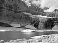 Grinnell Glacier (4119268745).jpg 1,600 × 1,200; 468 KB
-
 Grinnell Glacier (4119269055).jpg 1,600 × 1,200; 499 KB
-
 Grinnell Glacier Trail (4119264193).jpg 1,600 × 1,200; 593 KB
-
 H20160919-0003—Mount Tamalpais in Infrared—Berkeley Rose Garden—DxO (29737460891).jpg 4,432 × 3,326; 5.53 MB
-
 Harris Wash (3685434386).jpg 1,600 × 1,200; 449 KB
-
 Heavens Peak (4169241425).jpg 1,600 × 1,200; 419 KB
-
 Hidden Lake (4176998806).jpg 1,600 × 1,067; 485 KB
-
 Iceberg Lake (4158170948).jpg 1,200 × 1,600; 522 KB
-
 Iceberg Lake (4158171542).jpg 1,600 × 1,200; 423 KB
-
 Landscape (3690967281).jpg 1,600 × 1,067; 447 KB
-
 Landscape (3691774080).jpg 1,600 × 1,067; 336 KB
-
 Little Death Hollow (3685116192).jpg 1,600 × 1,200; 577 KB
-
 Low Clouds in Swiftcurrent Valley (4171824101).jpg 1,200 × 1,600; 407 KB
-
 McGath Bench (3684621179).jpg 1,600 × 1,200; 499 KB
-
 Mills Lake (6967220187).jpg 1,200 × 1,600; 376 KB
-
 Monster Tower and Washerwoman Arch (7257520642).jpg 1,600 × 1,067; 613 KB
-
 Nanga Parbat from Fairy Meadows (7275734156).jpg 1,024 × 683; 582 KB
-
 Navajo Sandstone in Buckhorn Wash (4056320428).jpg 1,600 × 1,200; 468 KB
-
 Never Summer Mountains from Trail Ridge Road (6280676325).jpg 1,600 × 1,067; 463 KB
-
 Panorama Infrared Photography By Ramin Kakavand.jpg 1,400 × 441; 506 KB
-
 Paungda Danda rock face (4518298287).jpg 1,600 × 1,200; 499 KB
-
 Ptarmigan Lake (4158173160).jpg 1,600 × 1,200; 533 KB
-
 Ptarmigan Lake Rock Folds (4158172938).jpg 1,600 × 1,067; 746 KB
-
 Redrock Falls (4172582470).jpg 1,141 × 1,600; 515 KB
-

-
 Ridge from Iceberg Lake Trail (4157407369).jpg 1,600 × 1,200; 560 KB
-
 Slide mountain aerial view.jpg 450 × 298; 68 KB
-
 Swiftcurrent Pass Trail (4172581998).jpg 1,600 × 1,067; 434 KB
-
 Swiftcurrent Valley (4158173832).jpg 1,600 × 1,067; 501 KB
-
 Tatopani (4524217592).jpg 1,600 × 1,200; 507 KB
-
 The Brandberg (3690968593).jpg 1,600 × 1,067; 343 KB
-
 Trail to Twin Falls, Pumpelly Pillar in distance (4176235283).jpg 1,200 × 1,600; 681 KB
-
 Tree on downhill trail. (4514936673).jpg 1,600 × 1,200; 626 KB
-
 View of Mt Washington and Lava Beds from Black Crater Trailhead (4103178303).jpg 1,600 × 1,200; 646 KB
-
 Welwitschia Plant, Brandberg in back (3691775546).jpg 1,600 × 1,200; 599 KB
-
 West Brandberg (3691772376).jpg 1,600 × 979; 249 KB


.jpg)
.jpg)
.jpg)
.jpg)
.jpg)
.jpg)
.jpg)


.jpg)
.jpg)
.jpg)
.jpg)
.jpg)
.jpg)
.jpg)
.jpg)
.jpg)
.jpg)
.jpg)
.jpg)
.jpg)
.jpg)
.jpg)
.jpg)
.jpg)
.jpg)
.jpg)
.jpg)
.jpg)
.jpg)
.jpg)
.jpg)
.jpg)
.jpg)
.jpg)

.jpg)
.jpg)
.jpg)
.jpg)
.jpg)
.jpg)
.jpg)
.jpg)
.jpg)