Category:Mouldsworth
Jump to navigation
Jump to search
English: Mouldsworth is a village and civil parish on the outskirts of Chester in the unitary authority of Cheshire West and Chester and the ceremonial county of Cheshire, England. It is located about 8 miles north east of Chester City Centre on the B5393 road. The nearest villages are Manley to the north west and Ashton Hayes to the south west. Delamere Forest is situated to the east of the village. At the 2001 Census the population was recorded at 302.
village and civil parish in Cheshire West and Chester, Cheshire, UK  | |||||
| Upload media | |||||
| Instance of | |||||
|---|---|---|---|---|---|
| Location | Cheshire West and Chester, Cheshire, North West England, England | ||||
| Population |
| ||||
| official website | |||||
 | |||||
Subcategories
This category has the following 3 subcategories, out of 3 total.
A
M
- Mouldsworth Motor Museum (2 F)
- Mouldsworth railway station (3 F)
Media in category "Mouldsworth"
The following 75 files are in this category, out of 75 total.
-
 'Super Tots' day nursery - geograph.org.uk - 423277.jpg 640 × 480; 133 KB
-
 A rather wet field - geograph.org.uk - 6762474.jpg 1,024 × 684; 110 KB
-
 A small pond - geograph.org.uk - 6762447.jpg 1,024 × 789; 132 KB
-
 Baker Way near Gongar Lane - geograph.org.uk - 4801071.jpg 1,200 × 800; 240 KB
-
 Bank Farm - geograph.org.uk - 6762483.jpg 1,024 × 684; 119 KB
-
 Beech trees alongside Dark Ark Lane - geograph.org.uk - 2613536.jpg 1,024 × 768; 256 KB
-
 Church of St Cuthbert by the Forest, Mouldsworth (geograph 6174125).jpg 1,024 × 768; 196 KB
-
 Coppicing on railway embankment - geograph.org.uk - 6762497.jpg 1,024 × 570; 191 KB
-
 Delamere Forest - geograph.org.uk - 21117.jpg 640 × 426; 145 KB
-
 Delamere Forest - geograph.org.uk - 63239.jpg 640 × 426; 151 KB
-
 Delamere Forest - geograph.org.uk - 63330.jpg 640 × 426; 156 KB
-
 Entrance to Manley - geograph.org.uk - 3968249.jpg 640 × 480; 95 KB
-
 Fields beside Dark Ark Lane, Manley - geograph.org.uk - 6573138.jpg 1,600 × 1,067; 743 KB
-
 Footpath in Mouldsworth - geograph.org.uk - 4818235.jpg 1,200 × 800; 227 KB
-
 Footpath through Delamere Forest - geograph.org.uk - 63251.jpg 640 × 426; 152 KB
-
 Footpath through Delamere Forest - geograph.org.uk - 63280.jpg 640 × 426; 151 KB
-

-
 Goshawk, Mouldsworth - geograph.org.uk - 4800941.jpg 1,200 × 800; 136 KB
-

-
 Kid's Playground at The Goshawk - geograph.org.uk - 4443835.jpg 3,684 × 2,904; 1.9 MB
-
 Manley - view along the Delamere Way - geograph.org.uk - 498536.jpg 640 × 480; 169 KB
-
 Mouldsworth - Wright's Gorse - geograph.org.uk - 224906.jpg 640 × 480; 99 KB
-
 Mouldsworth Football Pitch - geograph.org.uk - 63199.jpg 640 × 426; 97 KB
-
 Mouldsworth Hall - geograph.org.uk - 423275.jpg 640 × 480; 110 KB
-
 Mouldsworth Motor Museum (closed) - geograph.org.uk - 2461964.jpg 4,000 × 3,000; 3.16 MB
-
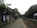
 Mouldsworth railway station - geograph.org.uk - 2817838.jpg 1,600 × 1,198; 532 KB
-
 Mouldsworth Railway Station - geograph.org.uk - 3957978.jpg 3,695 × 2,548; 3.24 MB
-
 Mouldsworth railway station from B5393 road bridge - geograph.org.uk - 2817841.jpg 1,600 × 1,198; 522 KB
-
 Mouldsworth railway station, Cheshire - geograph.org.uk - 3723998.jpg 1,024 × 768; 232 KB
-
 Mouldsworth Station - geograph.org.uk - 2613517.jpg 1,024 × 768; 163 KB
-
 Mouldsworth station buildings - geograph.org.uk - 6174110.jpg 1,024 × 768; 213 KB
-
 Mouldsworth Station House - geograph.org.uk - 4447091.jpg 3,760 × 2,908; 1.35 MB
-
 Mouldsworth Station looking east - geograph.org.uk - 2613509.jpg 1,024 × 768; 174 KB
-
 Mouldsworth Station looking west - geograph.org.uk - 2613505.jpg 1,024 × 768; 152 KB
-
 Mouldsworth Station sign - geograph.org.uk - 6762493.jpg 1,024 × 838; 210 KB
-
 Mouldsworth Station sign - geograph.org.uk - 6762495.jpg 1,024 × 624; 146 KB
-
 Multiple crossing - geograph.org.uk - 4801161.jpg 1,200 × 800; 261 KB
-
 Near Bank Farm - geograph.org.uk - 6762485.jpg 1,024 × 626; 70 KB
-
 Norton's Lane - geograph.org.uk - 2463432.jpg 4,000 × 3,000; 2.46 MB
-
 Norton's Lane looking east - geograph.org.uk - 2463449.jpg 4,000 × 3,000; 2.31 MB
-
 Norton's Lane near Mouldsworth - geograph.org.uk - 2462015.jpg 4,000 × 3,000; 3.27 MB
-
 Pasture in winter - geograph.org.uk - 6762480.jpg 1,024 × 626; 93 KB
-
 Pasture north of Ashton Brook - geograph.org.uk - 6762444.jpg 1,024 × 684; 110 KB
-
 Path to Ashton parish church - geograph.org.uk - 4801062.jpg 1,200 × 800; 192 KB
-
 Railway through Delamere Forest - geograph.org.uk - 63337.jpg 640 × 426; 116 KB
-
 Smithy Lane towards Mouldsworth - geograph.org.uk - 2461842.jpg 4,000 × 3,000; 3.26 MB
-
 Smithy Lane, Mouldsworth - geograph.org.uk - 2461751.jpg 4,000 × 3,000; 3.45 MB
-
 Smithy Lane, Mouldsworth - geograph.org.uk - 2461808.jpg 4,000 × 3,000; 3.04 MB
-
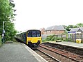 Sprinter leaving Mouldsworth station - geograph.org.uk - 6174099.jpg 1,024 × 768; 229 KB
-
 Station Road, Mouldsworth - geograph.org.uk - 5058824.jpg 640 × 480; 75 KB
-
 Stone stile in Mouldsworth - geograph.org.uk - 4818230.jpg 1,200 × 800; 237 KB
-
 The Goshawk, Station Road, Mouldsworth - geograph.org.uk - 6174116.jpg 1,024 × 768; 177 KB
-
 The Sidings, Mouldsworth Station - geograph.org.uk - 4443853.jpg 3,772 × 2,744; 1.46 MB
-
 Wall postbox in Mouldsworth - geograph.org.uk - 6174115.jpg 1,024 × 768; 201 KB
-
 West of Delamere Forest - geograph.org.uk - 1637427.jpg 640 × 427; 86 KB
-
 Y Junction, Delamere Forest - geograph.org.uk - 63245.jpg 640 × 426; 141 KB
-
 Cheshire railings - geograph.org.uk - 219048.jpg 640 × 481; 136 KB
-
 Cows on the Longster Trail - geograph.org.uk - 224901.jpg 640 × 480; 99 KB
-
 Dairy herd beside Norton's Lane - geograph.org.uk - 422485.jpg 614 × 460; 277 KB
-
 Footpath and Gate Entrance - geograph.org.uk - 331503.jpg 640 × 480; 272 KB
-
 Manley - picnic area in Delamere Forest - geograph.org.uk - 207834.jpg 640 × 480; 128 KB
-

-
 Mouldsworth - Congar Lane railway bridge - geograph.org.uk - 224909.jpg 631 × 473; 353 KB
-
 Mouldsworth old railway cutting - geograph.org.uk - 60249.jpg 640 × 480; 98 KB
-

-
 New House Farm - geograph.org.uk - 422475.jpg 614 × 460; 272 KB
-
 New Pale Lodge Manley - geograph.org.uk - 406165.jpg 640 × 480; 77 KB
-
 New Pale Road near Mouldsworth - geograph.org.uk - 63229.jpg 640 × 426; 116 KB
-
 Quarry Lane Junction - geograph.org.uk - 331452.jpg 640 × 480; 247 KB
-
 Quarry Lane, Manley - geograph.org.uk - 331480.jpg 640 × 480; 245 KB
-
 Rangeway Bank Farm, Manley - geograph.org.uk - 499651.jpg 640 × 480; 85 KB
-
 South along the Longster Trail - geograph.org.uk - 422482.jpg 614 × 460; 320 KB
-
 Tarvin Road thro'Mouldsworth - geograph.org.uk - 63215.jpg 640 × 426; 110 KB
-
 The Goshawk pub,Mouldsworth - geograph.org.uk - 100186.jpg 640 × 480; 82 KB
-
 Woodside Farm - geograph.org.uk - 111723.jpg 640 × 480; 94 KB


.jpg)


_-_geograph.org.uk_-_2461964.jpg)


