Category:Motacillidae distribution maps
Jump to navigation
Jump to search
Subcategories
This category has only the following subcategory.
Media in category "Motacillidae distribution maps"
The following 22 files are in this category, out of 22 total.
-
 Anthus bogotensis map.svg 1,181 × 1,732; 1.9 MB
-
 Anthus brevirostris map.svg 1,181 × 1,732; 1.9 MB
-
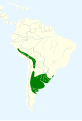
 Anthus chacoensis map.svg 1,181 × 1,732; 1.9 MB
-
 Anthus correndera map.svg 1,181 × 1,732; 2.22 MB
-
 Anthus furcatus map 2.svg 1,181 × 1,732; 1.91 MB
-
 Anthus furcatus map.svg 1,181 × 1,732; 1.91 MB
-
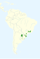
 Anthus hellmayri map.svg 1,181 × 1,732; 1.92 MB
-
 Anthus lutescens map.svg 454 × 608; 195 KB
-
 Anthus nattereri map.svg 1,181 × 1,732; 1.9 MB
-
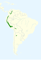
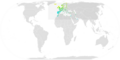
 Anthus peruvianus map.svg 820 × 1,000; 1 MB
-
 Anthus petrosus map.png 720 × 600; 75 KB
-
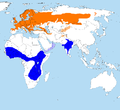
 Anthus spinoletta mapcomm.png 685 × 400; 178 KB
-
 Anthus trivialis distr.png 2,428 × 2,218; 298 KB
-
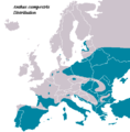 AnthusCampestris distribution.PNG 415 × 422; 11 KB
-
 AnthusTrivialisIUCNver2018 2.png 3,507 × 2,480; 841 KB
-
 Jones pipit map sept23 2010 final.jpg 2,550 × 3,300; 1.08 MB
-
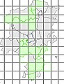
 Meadow Pipit ebird data map.png 3,750 × 1,890; 577 KB
-
 Motacilla capensis, verspreidingskaart met subspp, a.png 1,000 × 1,000; 93 KB
-
 Motacilla tschutschensis map.svg 717 × 477; 1.79 MB
-
 MotacillaFlavaIUCN.svg 1,052 × 744; 16.7 MB
-
 MotacillaFlavaIUCNver2019 1.png 3,507 × 2,480; 865 KB
-
 Trobat - Hàbitat Solsonès.jpg 229 × 299; 20 KB


