Category:Moräne zwischen Andechs und Frieding
Jump to navigation
Jump to search
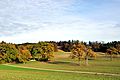
Deutsch: Moräne zwischen Andechs und Frieding im Landschaftsschutzgebiet „Westlicher Teil des Landkreises Starnberg“. Geotop 188R015.
Geotop in Landkreis Starnberg in Bavaria, Germany  | |||||
| Upload media | |||||
| Instance of | |||||
|---|---|---|---|---|---|
| Location | Andechs, Starnberg, Upper Bavaria, Bavaria, Germany | ||||
| Heritage designation | |||||
| Width |
| ||||
| Length |
| ||||
| Area |
| ||||
| Elevation above sea level |
| ||||
| official website | |||||
 | |||||
Media in category "Moräne zwischen Andechs und Frieding"
The following 3 files are in this category, out of 3 total.
-
 Andechs, Moräne HB-01.jpg 3,001 × 1,993; 3.99 MB
-
 Andechs, Moräne HB-02.jpg 3,001 × 1,993; 4.49 MB
-
 Andechs, Moräne HB-03.jpg 3,001 × 1,993; 3.82 MB

