Category:Moordkoppie (KwaZulu-Natal)
Jump to navigation
Jump to search
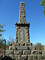
Afrikaans: Moordkoppie, beskou as KwaMatiwane of "Plek van die dooies" van Dingaan se tyd, is minder as 'n kilometer noord van Dingaanstat geleë,[1][2] op die plaas Uitzoek 317, Babanango. 'n Obelisk met plaketinskripsie kyk oor die Retief-massagraf aan die trapvoet.
English: Execution hill, taken to be KwaMatiwane or "Place of the dead"[3] of Dingane's time, is less than a kilometer to the north of uMgungundlovu, on the farm Uitzoek 317, Babanango. The inscribed obelisk atop the hill faces the Retief mass grave at the base of the steps.
| Object location | | View all coordinates using: OpenStreetMap |
|---|
| This category shows a South African Protected Site with SAHRA file reference 9/2/401/0002. |
Execution hill near uMgungundlovu  | |||||
| Upload media | |||||
| Instance of | |||||
|---|---|---|---|---|---|
| Location | Ulundi Local Municipality, Zululand District Municipality, KwaZulu-Natal, RSA | ||||
 | |||||
Note: Unrelated to Hill of Executions (Ukraine), or Moordkoppie (Namibia).
Media in category "Moordkoppie (KwaZulu-Natal)"
The following 7 files are in this category, out of 7 total.
-
 Moordkoppie-monument, a, Dingaanstat.jpg 4,000 × 3,000; 5.05 MB
-
 Moordkoppie-monument, b, Dingaanstat.jpg 4,000 × 3,000; 3.6 MB
-
 Moordkoppie-monument, c, Dingaanstat.jpg 2,084 × 2,740; 3.81 MB
-
 Moordkoppie-monument, inskrif, Dingaanstat.jpg 4,000 × 3,000; 3.89 MB
-
 Piet Retief and Men 2011 301.jpg 1,712 × 2,288; 861 KB
-
 Piet Retief Monument 2011 298.jpg 1,712 × 2,288; 675 KB
-
 Retief-massagraf, a, Moordkoppie.jpg 3,923 × 2,954; 3.64 MB


