Category:Moor Row
Jump to navigation
Jump to search
English: Moor Row is a village situated in North West England. It is in Cumbria and is located on a minor road off the A595 road south of Whitehaven.
village in Borough of Copeland, Cumbria, United Kingdom  | |||||
| Upload media | |||||
| Instance of | |||||
|---|---|---|---|---|---|
| Location | Egremont, Copeland, Cumbria, North West England, England | ||||
 | |||||
Subcategories
This category has the following 2 subcategories, out of 2 total.
B
- Moorlinse Buch (8 F)
K
- Keekle Viaduct (5 F)
Media in category "Moor Row"
The following 20 files are in this category, out of 20 total.
-

-
 Cycle Path under old railway bridge - geograph.org.uk - 447180.jpg 640 × 480; 105 KB
-
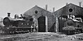 Furness Railway G5 Class No. 57 and Furness Railway G1 Class No. 83.jpg 3,799 × 1,880; 2.03 MB
-
 Moor Row station, ex-Whitehaven, Cleator & Egremont Railway 1952 (geograph 5395765).jpg 2,365 × 1,297; 1.38 MB
-
 National Cycle Network route 72 - geograph.org.uk - 269187.jpg 640 × 480; 176 KB
-
 National Cycle Network route 72 - geograph.org.uk - 269860.jpg 640 × 480; 157 KB
-
 Postbox crossroads. - geograph.org.uk - 89932.jpg 640 × 480; 85 KB
-
 Road bridge over C2C Cycleway - geograph.org.uk - 89929.jpg 640 × 480; 99 KB
-
 West Cumberland Hospital - geograph.org.uk - 79516.jpg 640 × 480; 76 KB
-

-
 Footbridge over old railway route. - geograph.org.uk - 89928.jpg 640 × 480; 106 KB
-
 Ingwell Hall, nr Whitehaven. - geograph.org.uk - 47637.jpg 640 × 470; 96 KB
-
 Keekle Bank. - geograph.org.uk - 89887.jpg 640 × 480; 62 KB
-
 Lone tree road. - geograph.org.uk - 89938.jpg 640 × 480; 111 KB
-
 Mirehouse Pond. - geograph.org.uk - 96256.jpg 640 × 452; 67 KB
-
 Pallaflat Farm. - geograph.org.uk - 96714.jpg 640 × 480; 48 KB
-
 Summergrove. - geograph.org.uk - 89933.jpg 640 × 480; 81 KB
-
 Whitehaven Swimming Pool. - geograph.org.uk - 89904.jpg 640 × 480; 44 KB
-
 Woodend Farm. - geograph.org.uk - 96252.jpg 640 × 420; 55 KB
-
 Wreah Junction looking South East. - geograph.org.uk - 89889.jpg 640 × 480; 80 KB
_(14777310871).jpg)


.jpg)


