Category:Monte Stabiè
Jump to navigation
Jump to search
|
Monte Stabiè has an entry on OpenStreetMap (show). |
locality in the Italian municipality of Stazzona  .jpg)  | |||||
| Upload media | |||||
| Instance of |
| ||||
|---|---|---|---|---|---|
| Location | Stazzona, Province of Como, Lombardy, Italy | ||||
| Elevation above sea level |
| ||||
 | |||||
Media in category "Monte Stabiè"
The following 8 files are in this category, out of 8 total.
-
 Path intersection in Stabiè, along VML4.jpg 4,234 × 3,546; 8.36 MB
-
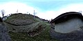 Photosphere along VML4 in Monte Stabiè, at a branching.jpg 5,322 × 2,661; 3.86 MB
-
 Photosphere along VML4, among the buildings of Monte Stabiè (2).jpg 5,322 × 2,661; 4.55 MB
-
 Photosphere along VML4, among the buildings of Monte Stabiè.jpg 5,322 × 2,661; 3.78 MB
-
 Photosphere along VML4, at the first building of Monte Stabiè (coming from Cragno).jpg 5,322 × 2,661; 5.29 MB
-
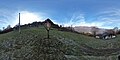 Photosphere by a crucifix along VML4, in Monte Stabiè.jpg 5,322 × 2,661; 4.05 MB
-
 Place name sign Monte Stabié, on a building.jpg 574 × 203; 62 KB
-
 The first building of Monte Stabiè along VML4, arriving from Cragno.jpg 3,725 × 3,061; 6.31 MB

.jpg)

.jpg)

