Category:Monte Schlacko
Jump to navigation
Jump to search
| Object location | | View all coordinates using: OpenStreetMap |
|---|
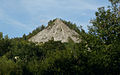
A Slag Heap in Siegen, Germany  | |||||
| Upload media | |||||
| Instance of | |||||
|---|---|---|---|---|---|
| Located in protected area | |||||
| Location | North Rhine-Westphalia, Germany | ||||
| Elevation above sea level |
| ||||
 | |||||
Media in category "Monte Schlacko"
The following 4 files are in this category, out of 4 total.
-
 Katholische Kirche Siegen-Weidenau.jpg 356 × 378; 17 KB
-
 Siegen Monte Schlacko.jpg 1,600 × 1,002; 833 KB
-
 Siegen Weidenau.jpg 700 × 324; 147 KB
-
 Uni Siegen.JPG 1,280 × 960; 900 KB


