Category:Mont Poupet
Jump to navigation
Jump to search
| Object location | | View all coordinates using: OpenStreetMap |
|---|
mountain  | |||||
| Upload media | |||||
| Instance of |
| ||||
|---|---|---|---|---|---|
| Made from material | |||||
| Location | Jura, Bourgogne-Franche-Comté, Metropolitan France, France | ||||
| Mountain range | |||||
| Elevation above sea level |
| ||||
 | |||||
Subcategories
This category has the following 3 subcategories, out of 3 total.
Media in category "Mont Poupet"
The following 23 files are in this category, out of 23 total.
-
 Crêt sud-ouest du mont Poupet.jpg 4,000 × 3,000; 5.06 MB
-
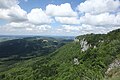
 Mont Poupet - img 50465.jpg 5,616 × 3,744; 7.8 MB
-
 Mont Poupet - img 50466.jpg 3,744 × 5,616; 9.12 MB
-
 Mont Poupet - img 50467.jpg 5,616 × 3,744; 9.39 MB
-
 Mont Poupet - img 50470.jpg 5,616 × 3,744; 8.68 MB
-
 Mont Poupet - img 50486.jpg 5,616 × 3,744; 7.11 MB
-
 Mont Poupet - img 50487.jpg 5,616 × 3,744; 10.44 MB
-
 Mont Poupet 4.jpg 5,472 × 3,648; 3.59 MB
-
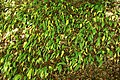 Mont Poupet, Ail des ours - img 50483.jpg 5,616 × 3,744; 10.52 MB
-
 Mont Poupet, Asperge des bois - img 50460.jpg 3,744 × 5,616; 5.56 MB
-
 Mont Poupet, Campanule agglomérée - img 50461.jpg 5,616 × 3,744; 6.47 MB
-
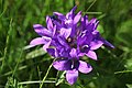 Mont Poupet, Campanule agglomérée - img 50462.jpg 5,616 × 3,744; 6.2 MB
-
 Mont Poupet, Orchis pyramidal - img 50485.jpg 3,744 × 5,616; 6.13 MB
-
 Mont Poupet, Trefle rougeatre - img 50479.jpg 3,744 × 5,616; 6.09 MB
-
 Montagny les Seurre 0018.JPG 4,000 × 3,000; 4.83 MB
-
 Poupet.JPG 2,576 × 1,932; 1.07 MB
-
 Pretin (39) Vue du Mont Poupet depuis la piste d'envol - 01.jpg 6,000 × 4,000; 10.19 MB
-
 Pretin (39) Vue du Mont Poupet depuis la piste d'envol - 02.jpg 6,000 × 4,000; 7.9 MB
-
 Pretin (39) Vue du Mont Poupet depuis la piste d'envol - 03.jpg 6,000 × 4,000; 10.28 MB
-
 Saint-Thiébaud (39) Monument commémoratif de la Résistance du Mont Poupet.jpg 4,000 × 6,000; 13.38 MB
-
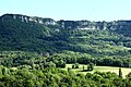
 Salins-les-Bains (39) Vue sur le Mont Poupet - 01.jpg 6,000 × 4,000; 10.82 MB
-
 Salins-les-Bains (39) Vue sur le Mont Poupet - 02.jpg 6,000 × 4,000; 10.14 MB
-
 Vue sur le mont poupet depuis le relais de champagne sur loue - panoramio.jpg 2,815 × 1,485; 1.97 MB


_Vue_du_Mont_Poupet_depuis_la_piste_d%27envol_-_01.jpg)
_Vue_du_Mont_Poupet_depuis_la_piste_d%27envol_-_02.jpg)
_Vue_du_Mont_Poupet_depuis_la_piste_d%27envol_-_03.jpg)
_Monument_comm%C3%A9moratif_de_la_R%C3%A9sistance_du_Mont_Poupet.jpg)
_Vue_sur_le_Mont_Poupet_-_01.jpg)
_Vue_sur_le_Mont_Poupet_-_02.jpg)
