Category:Mongolia AMS Topographic Maps
Jump to navigation
Jump to search
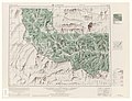
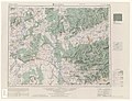
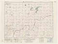
English: Original maps prepared by the Army Map Service as part of Series L522. Includes portions of China (PRC) (before diplomatic recognition from the USA), Mongolia, and the Soviet Union (USSR; present-day Russia). Via: [1]
-
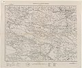
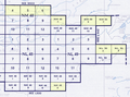 Index Map

Media in category "Mongolia AMS Topographic Maps"
The following 11 files are in this category, out of 11 total.
-
Index map.png 989 × 736; 1.24 MB
-
 Txu-pclmaps-oclc-6612004-biruuta.jpg 5,389 × 4,154; 4.38 MB
-
 Txu-pclmaps-oclc-6612004-eryeen-tsab.jpg 5,494 × 4,097; 4.3 MB
-
 Txu-pclmaps-oclc-6612004-gorodok.jpg 5,396 × 4,147; 4.53 MB
-
 Txu-pclmaps-oclc-6612004-kyakhta.jpg 5,360 × 4,104; 4.96 MB
-
 Txu-pclmaps-oclc-6612004-sangiin-dalay-nuur.jpg 5,368 × 4,090; 4.13 MB
-
 Txu-pclmaps-oclc-6612004-shonuy.jpg 5,404 × 4,140; 7.19 MB
-
 Txu-pclmaps-oclc-6612004-suuji-hiid.jpg 5,324 × 4,075; 4.85 MB
-
 Txu-pclmaps-oclc-6612004-tsagaan-nuuriin-suma.jpg 5,418 × 4,075; 4.33 MB
-
 Txu-pclmaps-oclc-6612004-uuldza.jpg 5,461 × 4,118; 6.23 MB
-
 Txu-pclmaps-oclc-8607404-mongolia-west.jpg 8,736 × 7,316; 11.89 MB


