Category:Monbardon
Jump to navigation
Jump to search
commune in Gers, France   | |||||
| Upload media | |||||
| Instance of | |||||
|---|---|---|---|---|---|
| Location |
| ||||
| Population |
| ||||
| Area |
| ||||
| Elevation above sea level |
| ||||
 | |||||
Subcategories
This category has the following 3 subcategories, out of 3 total.
Media in category "Monbardon"
The following 15 files are in this category, out of 15 total.
-
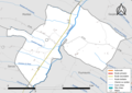 32260-Monbardon-Routes-Hydro.png 3,507 × 2,480; 1.28 MB
-
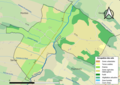 32260-Monbardon-Sols.png 3,507 × 2,480; 1.4 MB
-
 D171.jpg 2,048 × 1,370; 1.36 MB
-
 Map commune FR insee code 32260.png 756 × 605; 39 KB
-
 Monbardon 1.jpg 2,048 × 1,370; 703 KB
-
 Monbardon 10.JPG 2,592 × 1,944; 3.6 MB
-
 Monbardon 11.JPG 2,592 × 1,944; 2.53 MB
-
 Monbardon 2.jpg 2,048 × 1,370; 588 KB
-
 Monbardon 4.jpg 2,048 × 1,370; 984 KB
-
 Monbardon 5.jpg 2,048 × 1,370; 1.09 MB
-
 Monbardon 6.jpg 2,048 × 1,370; 1.08 MB
-
 Monbardon 7.JPG 2,592 × 1,944; 2.92 MB
-
 Monbardon 8.JPG 2,592 × 1,944; 2.25 MB
-
 Monbardon kasteel.jpg 2,048 × 1,370; 1.1 MB
-
 Population - Municipality code 32260.svg 475 × 355; 12 KB


