Category:Molwerk 1, Den Hoorn
Jump to navigation
Jump to search
| Object location | | View all coordinates using: OpenStreetMap |
|---|
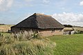
Nederlands: Schuur met rieten kap - Gemeentelijk monument nr. G33 aangewezen -23-6-2009 - anno 1850
Media in category "Molwerk 1, Den Hoorn"
The following 4 files are in this category, out of 4 total.
-
 Texel - Molwerk 1 Den Hoorn-2022-001.jpg 4,272 × 2,848; 2.76 MB
-
 Texel - Molwerk 1 Den Hoorn-2022-002.jpg 4,272 × 2,848; 2.29 MB
-
 Texel - Molwerk 1 Den Hoorn-2022-003.jpg 4,272 × 2,848; 3.78 MB
-
 Texel - Molwerk 1 Den Hoorn-2022-004.jpg 4,272 × 2,848; 3.24 MB


