Category:Moll's map collection
Jump to navigation
Jump to search
Deutsch: Als Kartensammlung Moll wird ein von Bernhard Paul Moll in den 1740er und 1750er Jahren zusammengestellter Atlas mit mehr als 12.000 einzelnen Karten und Ansichten bezeichnet. Die Sammlung befindet sich in der Mährischen Landesbibliothek in Brünn/Brno (siehe auch Fabian-Handbuch). Digitalisate: http://mapy.mzk.cz/
English: The Moll Collection is a commonly used name for the atlas, collected in the 1740s and 1750s by the German diplomat Bernhard Paul Moll, consisting of c. 12000 units. It is now held by the Moravian State Library in Brno, Czech Republic. Foro digitized maps, see http://mapy.mzk.cz/
Subcategories
This category has the following 3 subcategories, out of 3 total.
Media in category "Moll's map collection"
The following 48 files are in this category, out of 48 total.
-
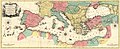
 1741 map of the Turkish Empire in Europe by Harenberg.jpg 9,118 × 7,930; 12.45 MB
-
 1768 map - Carte Geographique de la nouvelle Communication entre le Danube &. la Moldau.jpg 5,232 × 7,542; 4.49 MB
-
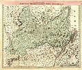
 1769 map of Eastern Europe by Tobias Conrad Lotter.jpg 23,743 × 11,575; 34.34 MB
-
 1769 map of Poland and Russia in Europe by Johann Gottlieb Facius.jpg 11,596 × 7,738; 15.89 MB
-
 1770 map of the Mediterranean Sea by Tobias Conrad Lotter.jpg 20,904 × 8,607; 28.3 MB
-
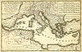 1770 map of the Mediterranean Sea published by Homannsche Erben.jpg 9,788 × 6,172; 10.16 MB
-
 18th century map of Hungary by Johann Baptist Homann.jpg 8,878 × 7,514; 14.55 MB
-
 18th-century map of Southeast Europe by Johann Jakob Lidl.jpg 20,399 × 12,269; 51.58 MB
-
 Bodenehr Mannheim c1715.jpg 4,791 × 2,998; 7.98 MB
-
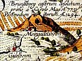 Brunsberg castrum Gigas1620.jpg 2,002 × 1,502; 643 KB
-
 Circuli Preroviensis Pars Australis.jpg 9,446 × 8,081; 21.2 MB
-
 Circuli Preroviensis Pars Borealis.jpg 9,374 × 8,007; 20.28 MB
-
 Gigas-Corvey.jpg 7,974 × 6,048; 5.43 MB
-
 Gigas-Paderborn.jpg 7,986 × 6,144; 5.86 MB
-
 Grundriss der Königlich-Preussischen Residenz-Stadt Berlin 1769.jpg 6,024 × 4,565; 8.17 MB
-
 Grundriß des Ihler Flusses 1730.jpg 6,959 × 5,159; 23.62 MB
-
 Hoefnagel Lindau.png 3,768 × 1,920; 16.53 MB
-
 Zollmann Hydrographia Germaniae.jpg 4,577 × 3,885; 17.37 MB
-
 Land-Charte des Churfürstenthums Brandenburg 1724.jpg 13,568 × 8,400; 37.39 MB
-
 Leopold Ravensburg von Westen c1730 koloriert Veitsburg.jpg 1,486 × 522; 414 KB
-
 Leopold Ravensburg von Westen c1730 koloriert Wappen.jpg 398 × 446; 90 KB
-
 Leopold Ravensburg von Westen c1730 koloriert.jpg 4,703 × 3,179; 10.65 MB
-
 Lüneburgum um 1740 (Sammlung Moll).jpg 4,510 × 4,029; 18.41 MB
-
 Map of Ghent by Braun and Hogenberg, 1650.jpg 7,721 × 5,508; 29.31 MB
-
 Map of Ghent by Pieter Husson.jpg 4,348 × 3,657; 13.26 MB
-
 Merian Buchhorn.jpg 3,063 × 2,375; 4.23 MB
-
 Merian Ravensburg (Sammlung Moll).jpg 5,783 × 4,588; 18.31 MB
-
 Merian Wolfegg 1643.jpg 2,807 × 2,160; 4.35 MB
-
 Nagl Wien 1770.jpg 5,851 × 4,867; 29.17 MB
-
 Orgel in der Kirchen Zur Heil Dreyfaltigkeit in Ulm cropped.jpg 990 × 1,691; 1.67 MB
-
 Orgel in der Kirchen Zur Heil Dreyfaltigkeit in Ulm.jpg 2,598 × 4,441; 6.46 MB
-
 Pieter van der Aa Ravensburg 18Jh Veitsburg und St Christina.jpg 2,394 × 794; 890 KB
-
 Pieter van der Aa Ravensburg 18Jh.jpg 7,134 × 3,144; 13.7 MB
-
 Plan de Spandau 1751-1770.jpg 1,499 × 1,170; 476 KB
-
 Pohled na Prahu Praga caput Regni Bohemiae Ouden Allen.jpg 33,161 × 15,516; 99.28 MB
-
 Praga caput Regni Bohemiae 3-Theatiner Kirch vor der Statt.jpg 2,982 × 1,555; 3.48 MB
-
 Principatvs Silesiae Oppaviensis novissima Tabula geographica.jpg 13,530 × 9,231; 34.26 MB
-
 Rauch Veriungter Abriss des Heyl Reichs Statt Lindaw.jpg 9,213 × 7,164; 37.45 MB
-
 Ruppin 1724.jpg 2,835 × 1,890; 6.12 MB
-
 Schmettau Plan de la Ville de Berlin 1750.jpg 9,358 × 13,410; 74.57 MB
-
 Seutter Berlin die Praechtigst. u. maechtigste Hauptstatt.. 1738b.jpg 4,631 × 4,008; 11.4 MB
-
 Seutter Stutgardia Würtenbergensis Ducatus Metropolis, Ausschnitt mit Hauptstätte.jpg 2,826 × 1,854; 5.06 MB
-
 Seutter Stutgardia Würtenbergensis Ducatus Metropolis, mit Suchhilfe.jpg 4,564 × 3,918; 20.75 MB
-
 Seutter Stutgardia Würtenbergensis Ducatus Metropolis.jpg 4,564 × 3,918; 20.44 MB
-
 Seutter Stuttgardia Schloss und Lusthaus.jpg 2,035 × 966; 1.69 MB
-
 Silesian principality of Krnov 1736.jpg 4,995 × 3,370; 10.99 MB
-
 Wildenstein-Merian.jpg 2,917 × 2,983; 5.12 MB
-
 Zdirec mapa 1720.jpg 695 × 391; 232 KB


.jpg)


.jpg)


