Category:Molenlanden in the 1860s
Jump to navigation
Jump to search
|
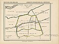
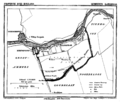
Media in category "Molenlanden in the 1860s"
The following 16 files are in this category, out of 16 total.
-
 Arkel, Gemeenteatlas van Nederland.jpg 2,652 × 2,099; 1.21 MB
-
 Bleskensgraaf en Hofwegen, Gemeenteatlas van Nederland.jpg 2,756 × 2,099; 1.14 MB
-
 Brandwijk, Gemeenteatlas van Nederland.jpg 2,528 × 2,107; 1.02 MB
-
 Giessen-Nieuwkerk, Gemeenteatlas van Nederland.jpg 2,600 × 2,115; 1.03 MB
-
 Goudriaan, Gemeenteatlas van Nederland.jpg 2,528 × 2,103; 1.04 MB
-
 Groot Ammers 1866.png 1,300 × 1,666; 163 KB
-
 Hoogblokland, Gemeenteatlas van Nederland.jpg 2,568 × 2,072; 1,006 KB
-
 Hoornaar, Gemeenteatlas van Nederland.jpg 2,476 × 2,074; 1.03 MB
-
 Langerak ZH 1866.png 1,608 × 1,393; 157 KB
-
 Molenaarsgraaf, Gemeenteatlas van Nederland.jpg 2,590 × 2,142; 1.05 MB
-
 Netherlands, Peursum, map, around 1865-1870.PNG 2,396 × 2,004; 4.7 MB
-
 Nieuw-Lekkerland 1867.png 1,600 × 1,365; 176 KB
-
 Nieuwpoort 1866.png 1,300 × 1,654; 143 KB
-
 Ottoland, Gemeenteatlas van Nederland.jpg 2,588 × 2,111; 1,000 KB
-
 Oud-Alblas, Gemeenteatlas van Nederland.jpg 2,596 × 2,103; 975 KB
-
 Wijngaarden, Gemeenteatlas van Nederland.jpg 2,628 × 2,129; 1.04 MB


