Category:Molí de Terrers (Capolat)
Jump to navigation
Jump to search
| Object location | | View all coordinates using: OpenStreetMap |
|---|
building in Lleida Province, Spain  | |||||
| Upload media | |||||
| Instance of | |||||
|---|---|---|---|---|---|
| Location | Capolat, Berguedà, Catalunya Central, Catalonia | ||||
| Architectural style | |||||
| Heritage designation |
| ||||
| Inception |
| ||||
| Elevation above sea level |
| ||||
 | |||||
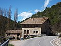
Català: Molí de Terrers. Vall de Lord, al peu del rierol del Coll de Jouet (Capolat)
This is a category about a building listed in the Catalan heritage register as Bé Cultural d'Interès Local (BCIL) under the reference IPA-3122. |
Media in category "Molí de Terrers (Capolat)"
This category contains only the following file.
-
 MOLI DE TERRERS - CAPOLAT.JPG 2,048 × 1,536; 1.56 MB