Category:Moioio Island
Jump to navigation
Jump to search
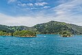
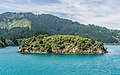
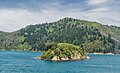
English: Mōioio Island is registered by Heritage New Zealand as a Wāhi Tapu area, with registration number 7364.
| Object location | | View all coordinates using: OpenStreetMap |
|---|
island in the Tory Channel, South Island, New Zealand  | |||||
| Upload media | |||||
| Instance of |
| ||||
|---|---|---|---|---|---|
| Location | Tory Channel / Kura Te Au, Marlborough District, New Zealand | ||||
| Located in or next to body of water | |||||
| Heritage designation |
| ||||
| Elevation above sea level |
| ||||
 | |||||
Media in category "Moioio Island"
The following 15 files are in this category, out of 15 total.
-
 Kaihinu Point & Moioio Island 01.jpg 3,000 × 2,000; 3.53 MB
-
 Kaihinu Point & Moioio Island 02.jpg 3,000 × 2,000; 3.69 MB
-
 Kaihinu Point & Moioio Island 03.jpg 2,979 × 1,986; 3.42 MB
-
 Kaihinu Point and Moioio Island.jpg 3,670 × 2,447; 7.26 MB
-
 Moioio Island 01.jpg 3,599 × 2,200; 7.04 MB
-
 Moioio Island 02.jpg 3,885 × 2,423; 8.06 MB
-
 Moioio Island 03.jpg 4,135 × 2,736; 9.31 MB
-
 Moioio Island 04.jpg 4,136 × 2,689; 10.36 MB
-
 Moioio Island 05.jpg 3,978 × 2,428; 7.8 MB
-
 Moioio Island 06.jpg 4,035 × 2,690; 9.84 MB
-
 Moioio Island 07.jpg 2,822 × 1,881; 6.75 MB
-
 Moioio Island 08.jpg 2,951 × 1,967; 4.13 MB
-
 Moioio Island 09.jpg 2,914 × 1,943; 4.27 MB
-
 Moioio Island 10.jpg 3,000 × 2,000; 4.75 MB
-
 Moioio Island 11.jpg 3,000 × 2,000; 4.32 MB


