Category:Mitchel Troy
Jump to navigation
Jump to search
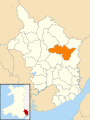
village and community in Monmouthshire, Wales  Yr olygfa i'r gogledd-orllewin, tuag at "Troy House" a thu hwnt. | |||||
| Upload media | |||||
| Instance of | |||||
|---|---|---|---|---|---|
| Location | Monmouthshire, Wales | ||||
 | |||||
Cymraeg: Pentref a chymuned yn Sir Fynwy yw Llanfihangel Troddi (Saesneg: Mitchel Troy); (SO4910). Saif dair milltir i'r de-orllewin o Drefynwy, heb fod ymhell o'r briffordd A40.
English: Mitchel Troy (that is, "church of St Michael on the River Trothy") is a village and Community in Monmouthshire Wales, United Kingdom.
Subcategories
This category has the following 3 subcategories, out of 3 total.
Media in category "Mitchel Troy"
The following 200 files are in this category, out of 600 total.
(previous page) (next page)-
 'Who Do You Think You Are^' - geograph.org.uk - 2692683.jpg 1,024 × 680; 137 KB
-
 2010 Wales Monmouthshire Community Mitchel Troy map.svg 512 × 682; 699 KB
-
 2024 Wales Monmouthshire Community Mitchel Troy map.svg 512 × 682; 603 KB
-
 30mph speed limit ahead, Mitchel Troy - geograph.org.uk - 2385577.jpg 640 × 480; 106 KB
-
 A barn and farmland - geograph.org.uk - 2696946.jpg 1,024 × 680; 206 KB
-
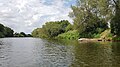
 A bend of the River Wye near Wyesham - geograph.org.uk - 3090149.jpg 640 × 480; 119 KB
-
 A distant view of Wonastow - geograph.org.uk - 3209785.jpg 640 × 481; 74 KB
-
 A fishing platform on the River Wye - geograph.org.uk - 6230523.jpg 3,024 × 1,701; 1.38 MB
-

-
 A slice of Monmouthshire farmland - geograph.org.uk - 4806028.jpg 1,600 × 901; 636 KB
-
 A small wood - geograph.org.uk - 2938732.jpg 640 × 480; 363 KB
-

-

-

-

-

-

-
 A view west along Waste Road - geograph.org.uk - 3233048.jpg 640 × 449; 81 KB
-

-

-

-

-

-

-

-
 A40 about to bridge a minor road - geograph.org.uk - 2058105.jpg 640 × 480; 53 KB
-
 A40 at Dingestow Court - geograph.org.uk - 2058103.jpg 640 × 480; 62 KB
-
 A40 east of Dingestow - geograph.org.uk - 2058098.jpg 640 × 480; 67 KB
-
 A40 Electronic sign at 09-58am - geograph.org.uk - 3686183.jpg 2,511 × 1,533; 1.7 MB
-
 A40 footbridge near Mitchel Troy - geograph.org.uk - 3680488.jpg 1,600 × 1,064; 297 KB
-
 A40 heading south west - geograph.org.uk - 3686175.jpg 2,493 × 1,629; 2.22 MB
-
 A40 in cutting north of Mitchel Troy - geograph.org.uk - 5163634.jpg 1,600 × 1,200; 714 KB
-
 A40 near Jingle Street - geograph.org.uk - 3686163.jpg 2,358 × 1,542; 1.81 MB
-
 A40 near Mitchel Troy - geograph.org.uk - 2058079.jpg 640 × 480; 55 KB
-
 A40 near the River Trothy - geograph.org.uk - 3680496.jpg 2,530 × 1,624; 2.27 MB
-
 A40 northbound - geograph.org.uk - 2324489.jpg 640 × 480; 40 KB
-
 A40 northbound, east of Mitchel Troy - geograph.org.uk - 2324527.jpg 640 × 480; 52 KB
-
 A40 parking area and SOS phone - geograph.org.uk - 3686170.jpg 2,442 × 1,530; 1.79 MB
-

-
 A40 Road Bridge, Dingestow - geograph.org.uk - 2026884.jpg 1,496 × 1,122; 821 KB
-
 A40 SW of Monmouth - geograph.org.uk - 2802207.jpg 640 × 455; 68 KB
-
 A40 west of Mitchel Troy - geograph.org.uk - 2324513.jpg 640 × 480; 47 KB
-

-
 A40 westbound near Dingestow - geograph.org.uk - 3558774.jpg 640 × 481; 38 KB
-
 A449 eastbound near Monmouth - geograph.org.uk - 2452101.jpg 640 × 481; 46 KB
-
 A449 Layby View - geograph.org.uk - 2629199.jpg 800 × 600; 120 KB
-
 A449 northbound near Dingestow - geograph.org.uk - 2324442.jpg 640 × 480; 50 KB
-

-
 Access lane to Upper Llantrothy Farm - geograph.org.uk - 3232686.jpg 640 × 623; 94 KB
-

-

-

-
 Almost in Dingestow - geograph.org.uk - 2478846.jpg 1,280 × 960; 599 KB
-
 Along the track to Hollybush Farm - geograph.org.uk - 4210908.jpg 2,560 × 1,920; 2.11 MB
-
 Another redundant telephone box - geograph.org.uk - 5347526.jpg 768 × 1,024; 320 KB
-

-
 Approaching Peartree Cottage - geograph.org.uk - 3502445.jpg 640 × 480; 129 KB
-
 Approaching the rear of Troy Farm - geograph.org.uk - 3366208.jpg 640 × 480; 76 KB
-

-
 Arable field to the east of Hollybush - geograph.org.uk - 5342548.jpg 1,024 × 576; 205 KB
-
 Arable land west of Wonastow - geograph.org.uk - 929120.jpg 640 × 480; 115 KB
-
 Architect's houses in Mitchel Troy - geograph.org.uk - 324167.jpg 640 × 480; 80 KB
-
 Arla milk tanker in Coed-y-fedw, Monmouthshire - geograph.org.uk - 5885491.jpg 1,024 × 606; 109 KB
-
 Autumn colours on the road north of Coed-y-fedw - geograph.org.uk - 4210859.jpg 2,560 × 1,920; 2.13 MB
-
 B4293 to Trellech - geograph.org.uk - 4804405.jpg 1,600 × 901; 741 KB
-
 Baled straw behind the churchyard - geograph.org.uk - 1024912.jpg 640 × 480; 170 KB
-

-
 Bare trees in a field - geograph.org.uk - 5342553.jpg 1,024 × 768; 256 KB
-
 Beech trees at Fedw-Fawr - geograph.org.uk - 2107058.jpg 681 × 1,024; 281 KB
-

-

-
 Bend in the road from Mitchel Troy to Monmouth - geograph.org.uk - 6057808.jpg 1,024 × 903; 317 KB
-

-

-
 Blackbird Nest in spruce tree crevice - geograph.org.uk - 6475591.jpg 3,024 × 4,032; 4.62 MB
-
 Bridge Farm farmhouse, Dingestow - geograph.org.uk - 3126873.jpg 640 × 480; 85 KB
-
 Bridge near Pen-yr-Heol - geograph.org.uk - 2695664.jpg 1,024 × 680; 313 KB
-
 Bridge over drainage channel, near Bryngwyn - geograph.org.uk - 4210995.jpg 2,560 × 1,920; 2.12 MB
-
 Bridge over Nant Wachan - geograph.org.uk - 2698256.jpg 1,024 × 680; 319 KB
-
 Bridge over River Trothy at Jingle Street - geograph.org.uk - 6270318.jpg 1,024 × 768; 349 KB
-
 Bridge over the A 40, Wonastow - geograph.org.uk - 4211205.jpg 2,560 × 1,920; 2.21 MB
-
 Bridge over the A40 - geograph.org.uk - 1173237.jpg 640 × 416; 87 KB
-

-
 Bridge over the River Trothy, Wonastow - geograph.org.uk - 4211197.jpg 2,560 × 1,920; 2.16 MB
-
 Bridge walls, Dingestow - geograph.org.uk - 3126782.jpg 640 × 480; 120 KB
-
 Bridleway from Mitchel Troy to Wonastow - geograph.org.uk - 2385642.jpg 640 × 596; 103 KB
-
 Bridleway near Lower Bailaeu - geograph.org.uk - 2696934.jpg 680 × 1,024; 274 KB
-
 Bridleway through Mill Wood, Dingestow - geograph.org.uk - 3126705.jpg 640 × 480; 141 KB
-
 Bridleway through Trealy Wood - geograph.org.uk - 5350160.jpg 768 × 1,024; 479 KB
-
 Bridleway to Loysey, 2016 - geograph.org.uk - 4804439.jpg 1,600 × 901; 753 KB
-
 British Gypsum lorry in Monmouth Services South - geograph.org.uk - 6239188.jpg 1,600 × 1,132; 332 KB
-
 Bus shelter on the B4293 - geograph.org.uk - 5605136.jpg 1,024 × 774; 258 KB
-

-

-

-

-

-

-
 Castle Earthworks, Dingestow - geograph.org.uk - 5422363.jpg 1,600 × 1,200; 479 KB
-
 Cattle grid, Court Farm - geograph.org.uk - 1171712.jpg 640 × 480; 94 KB
-
 Christiania Cottage NE of Raglan - geograph.org.uk - 3233200.jpg 628 × 640; 96 KB
-
 Church Farm Guest House, Mitchel Troy - geograph.org.uk - 2385983.jpg 640 × 559; 140 KB
-
 Churchyard, St Catwg, Cwmcarvan - geograph.org.uk - 2026902.jpg 1,496 × 1,122; 899 KB
-
 Coed-y-fedw bus stop - geograph.org.uk - 5885501.jpg 1,024 × 908; 166 KB
-
 Common Road, Mitchel Troy - geograph.org.uk - 3209779.jpg 640 × 480; 73 KB
-
 Communications centre, Mitchel Troy - geograph.org.uk - 2385951.jpg 640 × 497; 85 KB
-
 Communications mast on Craig-y-dorth - geograph.org.uk - 5200947.jpg 4,000 × 3,000; 3.5 MB
-
 Comonin west of Mitchel Troy - geograph.org.uk - 3210148.jpg 640 × 439; 72 KB
-

-
 Cottages in Dingestow - geograph.org.uk - 2692402.jpg 1,024 × 680; 225 KB
-
 Country lane near Cwmcarvan - geograph.org.uk - 2106923.jpg 681 × 1,024; 191 KB
-
 Country road above the Trothy valley - geograph.org.uk - 5347475.jpg 1,024 × 768; 248 KB
-
 Country road near Cefn-garw Farm - geograph.org.uk - 3439024.jpg 1,024 × 680; 165 KB
-
 Country road near Raglan Castle - geograph.org.uk - 5342558.jpg 1,024 × 768; 223 KB
-
 Country road near Ty-mawr - geograph.org.uk - 5342497.jpg 1,024 × 768; 240 KB
-
 Country road to the east of Ty-mawr - geograph.org.uk - 5342512.jpg 1,024 × 768; 282 KB
-
 Cow path - geograph.org.uk - 2478898.jpg 1,280 × 960; 601 KB
-
 Craig-y-Dorth battlefield 1404 - geograph.org.uk - 6440615.jpg 1,024 × 579; 126 KB
-
 Cross in Dingestow churchyard - geograph.org.uk - 2412705.jpg 680 × 1,024; 288 KB
-
 Crossroads near Tregare - geograph.org.uk - 3442447.jpg 680 × 1,024; 215 KB
-
 Cwmcarvan Lane - geograph.org.uk - 2798133.jpg 1,024 × 577; 301 KB
-
 Dairy cows in a Dingestow field, Monmouthshire - geograph.org.uk - 5889506.jpg 1,024 × 734; 200 KB
-
 Dead tree - geograph.org.uk - 2696940.jpg 680 × 1,024; 210 KB
-
 Dingestow - geograph.org.uk - 2478869.jpg 1,280 × 960; 586 KB
-
 Dingestow Castle Mound - geograph.org.uk - 2478886.jpg 1,280 × 960; 596 KB
-

-

-
 Dingestow church - geograph.org.uk - 2410508.jpg 1,024 × 680; 263 KB
-
 Dingestow church - geograph.org.uk - 2412707.jpg 1,024 × 680; 193 KB
-
 Dingestow church - geograph.org.uk - 2692401.jpg 1,024 × 680; 253 KB
-
 Dingestow churchyard and Mill Farm, Dingestow - geograph.org.uk - 6270334.jpg 1,024 × 768; 270 KB
-
 Dingestow Post Office and Stores - geograph.org.uk - 3502239.jpg 640 × 480; 84 KB
-
 Dingestow Post Office ^ Stores - geograph.org.uk - 2391297.jpg 640 × 542; 78 KB
-
 Dingestow Telephone Exchange - geograph.org.uk - 5039413.jpg 800 × 745; 231 KB
-
 Dingestow Village Hall - geograph.org.uk - 2391288.jpg 640 × 480; 71 KB
-
 Dingestow Village Hall - geograph.org.uk - 2478859.jpg 1,280 × 960; 556 KB
-
 Dingestow Village Hall - geograph.org.uk - 3503750.jpg 640 × 480; 73 KB
-
 Dingestow Village Hall - geograph.org.uk - 5039466.jpg 800 × 460; 81 KB
-
 Dingestow Village Hall, with telephone box - geograph.org.uk - 4211104.jpg 2,560 × 1,920; 2.05 MB
-
 Directions and distances sign near Dingestow - geograph.org.uk - 5889570.jpg 1,024 × 743; 226 KB
-
 Ditch near Fishpool Farm - geograph.org.uk - 2692407.jpg 1,024 × 680; 268 KB
-
 Downhill view - geograph.org.uk - 2477374.jpg 1,280 × 960; 604 KB
-
 Driveway to Llwyn-crwn - geograph.org.uk - 2695682.jpg 1,024 × 680; 287 KB
-
 Driveway to Talocher Farm - geograph.org.uk - 1173260.jpg 480 × 640; 139 KB
-
 Duffield Lane - geograph.org.uk - 167432.jpg 640 × 480; 117 KB
-

-

-

-
 Edge of woodland - geograph.org.uk - 4804446.jpg 1,600 × 901; 671 KB
-

-

-
 End of the 30 zone south of Dingestow - geograph.org.uk - 5039387.jpg 751 × 800; 188 KB
-

-

-

-

-
 Entrance road to Square Farm Shop, Mitchel Troy - geograph.org.uk - 6240812.jpg 1,600 × 1,015; 357 KB
-

-
 Entrance to Bourne Farm, Dingestow - geograph.org.uk - 5889504.jpg 1,024 × 685; 179 KB
-
 Entrance to Church Farm Guest House - geograph.org.uk - 1024900.jpg 640 × 480; 285 KB
-
 Entrance to Court Farm - geograph.org.uk - 2692406.jpg 1,024 × 680; 218 KB
-

-
 Entrance to Green Lawns Kennels near Dingestow - geograph.org.uk - 5889484.jpg 1,024 × 999; 290 KB
-

-

-
 Entrance to Talocher Farm - geograph.org.uk - 1173252.jpg 640 × 480; 127 KB
-

-

-

-
 Entrance to Trefaldu - geograph.org.uk - 5340101.jpg 1,024 × 768; 278 KB
-

-
 Esso filling station in Monmouth South Service Station - geograph.org.uk - 6239131.jpg 1,600 × 1,218; 327 KB
-
 Farm access bridge over A40 north of Mitchel Troy - geograph.org.uk - 5163642.jpg 1,600 × 1,200; 695 KB
-
 Farm building in rural Monmouthshire near Dingestow - geograph.org.uk - 5888070.jpg 3,621 × 1,941; 1.02 MB
-

-
 Farm buildings at Llwyn-y-celyn - geograph.org.uk - 4804501.jpg 1,600 × 901; 777 KB
-

-
 Farm road near Great Bailea Farm - geograph.org.uk - 2696917.jpg 1,024 × 680; 191 KB
-
 Farm road to Great Bailea Farm - geograph.org.uk - 2692656.jpg 1,024 × 680; 198 KB
-
 Farm track north of Coed-y-fedw, near Dingestow - geograph.org.uk - 4210853.jpg 2,560 × 1,920; 2.12 MB
-

-
 Farm track with small trees - geograph.org.uk - 6270325.jpg 1,024 × 768; 249 KB
-

-
 Farmland access track - geograph.org.uk - 5347469.jpg 1,024 × 768; 321 KB
-
 Farmland and Telltale Wood - geograph.org.uk - 2693528.jpg 1,024 × 680; 180 KB
-
 Farmland around The Bourne - geograph.org.uk - 5340108.jpg 1,024 × 768; 275 KB
-
 Farmland at Cwmcarvan - geograph.org.uk - 2106909.jpg 1,024 × 681; 155 KB
-
 Farmland at Dingestow - geograph.org.uk - 2695654.jpg 1,024 × 680; 250 KB
-
 Farmland at Pen-yr-Heol - geograph.org.uk - 2695689.jpg 1,024 × 680; 156 KB
-
 Farmland at Penrhos - geograph.org.uk - 3441000.jpg 1,024 × 680; 245 KB
-
 Farmland near Cae Barn - geograph.org.uk - 5347548.jpg 1,024 × 768; 276 KB
-
 Farmland near Dingestow - geograph.org.uk - 2692414.jpg 1,024 × 680; 228 KB
-
 Farmland near Little Wonastow Farm - geograph.org.uk - 2693511.jpg 1,024 × 680; 220 KB
-
 Farmland near Lower Tre-fal-du - geograph.org.uk - 5340096.jpg 1,024 × 768; 276 KB
-
 Farmland near Pen-yr-Heol - geograph.org.uk - 2692416.jpg 1,024 × 680; 305 KB
-
 Farmland near Pen-yr-Heol - geograph.org.uk - 2692420.jpg 1,024 × 680; 234 KB
-
 Farmland near Pen-yr-Heol - geograph.org.uk - 2696938.jpg 1,024 × 680; 203 KB
-
 Farmland near Penrhos - geograph.org.uk - 2692662.jpg 1,024 × 680; 213 KB
-
 Farmland north of Worthybrook - geograph.org.uk - 929130.jpg 640 × 364; 51 KB
-


