Category:Mississippi River in the 18th century
Jump to navigation
Jump to search
| NO WIKIDATA ID FOUND! Search for Mississippi River in the 18th century on Wikidata | |
| Upload media |
Subcategories
This category has the following 2 subcategories, out of 2 total.
C
I
Media in category "Mississippi River in the 18th century"
The following 24 files are in this category, out of 24 total.
-

-
 1721 Map of the new part of French Louisiana.jpg 8,104 × 6,291; 14.19 MB
-
-

-

-
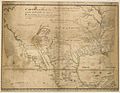
 A map of Florida and ye Great Lakes of Canada - by Robt. Morden. NYPL433721.tiff 1,293 × 1,404; 5.2 MB
-

-
 Archives nationales d’outre-mer - Louisiane - Jacques-Nicolas Bellin - 1744 - 001.jpg 5,262 × 3,921; 3.73 MB
-

-
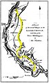
 ChickasawWars.jpg 490 × 809; 155 KB
-
 Côtes des environs de la rivière Mississippi en 1701.jpg 1,743 × 1,073; 886 KB
-
 Embouchure du Missisipi, Fort rond à droite, BNF.tif 5,985 × 4,602; 78.8 MB
-
 Embouchure du Missisipi, fort rond à gauche, BNF.tif 3,008 × 2,111; 6.06 MB
-
 Illinois 1718.jpg 589 × 737; 232 KB
-
 Kaskaskia Cahokia Trail Map 1778.jpg 555 × 930; 100 KB
-
 La Rivière de Missisipi- 1715 - Nicolas de Fer 1646-1720.JPG 1,104 × 794; 123 KB
-
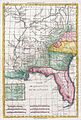
 Map of the Country about the Mississippi, Circa 1755 WDL9587.png 1,729 × 1,024; 2.66 MB
-
 Mississippi river map 1702.jpg 300 × 250; 10 KB
-
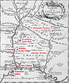 Montigny map with locations.jpg 863 × 1,036; 454 KB
-

-

-
 Vue de la colonie espagnole du Mississippi en 1802 - carte reduite Haute Louisiane.jpg 1,059 × 1,200; 883 KB
-
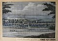 Watercolor Painting of St. Louis Attributed to Albert J.F. Muegge.jpg 2,937 × 2,074; 2.7 MB
-
 Delisle Carte de la Louisiane et du cours du Mississippi 1718 UTA.jpg 8,048 × 5,957; 14.47 MB
_-_Geographicus_-_AmeriqueSeptentrionale-covensmortier-1708.jpg)


.jpg)


_-_containing_a_description_of_the_countries_that_lye_on_both_sides_of_the_river_Mississippi_-_with_an_account_of_(20430962440).jpg)


