Category:Missionary maps
Jump to navigation
Jump to search
Subcategories
This category has the following 2 subcategories, out of 2 total.
M
Media in category "Missionary maps"
The following 29 files are in this category, out of 29 total.
-
 1846 map - The Protestant missionary map of the world.tif 10,588 × 6,601; 200 MB
-
 1861 map - The pictorial missionary map of the world.tif 8,744 × 5,789; 144.84 MB
-
 1874 French missionary map of Zhejiang Province.jpg 4,549 × 4,950; 4.56 MB
-

-

-

-

-

-
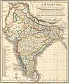 A language map of India prepared for the missionary projects at Serampore, 1822.jpg 1,155 × 1,400; 259 KB
-
 Carte des missions catholiques en Australie - btv1b532580360.jpg 11,680 × 9,068; 13.72 MB
-
 Comboni Missionaries Map.png 1,500 × 740; 54 KB
-

-
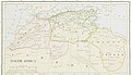
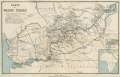 Map of Lower Congo.tif 8,325 × 5,374; 256.03 MB
-

-

-

-

-
-

-
-

-

-
-

-
 The pletorial missionary Map of the world - btv1b84391995.jpg 11,682 × 7,806; 15.86 MB
-
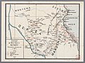
 United presbyterian missionary Map of old Calabar river - btv1b84394870.jpg 4,176 × 5,711; 2.85 MB
-
-
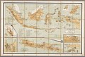
 Zendingskaart van Ned OostIndi en Suriname - Universiteitsbibliotheek VU.jpg 5,278 × 2,841; 2.15 MB
-
 Zendingskaart van Oost en WestIndi kleine uitgaaf - Universiteitsbibliotheek VU.jpg 4,712 × 3,183; 2.44 MB

.jpg)
.jpg)
.jpg)
.jpg)
.jpg)


_(14779836314).jpg)
_(14578098409).jpg)
_(14586718767).jpg)
_(14773141035).jpg)
_(14789478813).jpg)

_(14580422319).jpg)
_(14580581837).jpg)
_-_btv1b52500673v_(001_of_354).jpg)
.jpg)
_(14592662709).jpg)


