Category:Mirani Fort
Jump to navigation
Jump to search
| This building is classified as Património de Influência Portuguesa .It is indexed in the SIPA database (Sistema de Informação para o Património Arquitetónico) under the reference 24610. |
| Object location | | View all coordinates using: OpenStreetMap |
|---|
 | |||||
| Upload media | |||||
| Instance of | |||||
|---|---|---|---|---|---|
| Part of |
| ||||
| Location | Muscat, Muscat Governorate, Oman | ||||
| Heritage designation | |||||
 | |||||
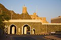
Fort Al-Mirani was built by the portuguese in Muscat harbor in the 1580s, together with the Fort Al Jalali, to protect the harbor after Muscat had twice been sacked by Ottoman forces.
Media in category "Mirani Fort"
The following 26 files are in this category, out of 26 total.
-
 Al Khor Mosque and Al Mirani Fort (47953967282).jpg 4,719 × 3,147; 7.52 MB
-
 Al Mirani Fort & Minaret of the Al Khor Mosque - Old Muscat.jpg 3,188 × 4,986; 10.29 MB
-
 Al Mirani Patio.jpg 3,024 × 4,032; 1.62 MB
-
 As Sultan Qaboos Port, Muscat - panoramio.jpg 3,264 × 2,176; 4.82 MB
-
 Fuerte de Al Mirani, Mascate, Omán, 2024-08-14, DD 38.jpg 5,652 × 8,478; 10.35 MB
-
 Fuerte de Al Mirani, Mascate, Omán, 2024-08-14, DD 42.jpg 8,122 × 5,670; 9.03 MB
-
 Fuerte de Al Mirani, Mascate, Omán, 2024-08-14, DD 43.jpg 7,920 × 5,280; 8.15 MB
-
 Fuerte de Al Mirani, Mascate, Omán, 2024-08-14, DD 45.jpg 8,628 × 5,752; 9.89 MB
-
 Fuerte de Al Mirani, Mascate, Omán, 2024-08-14, DD 47.jpg 5,312 × 7,968; 10.44 MB
-
 Fuerte de Al Mirani, Mascate, Omán, 2024-08-14, DD 49.jpg 8,346 × 5,564; 8.77 MB
-
 Fuerte de Al Mirani, Mascate, Omán, 2024-08-14, DD 50.jpg 5,488 × 8,232; 7.94 MB
-
 Fuerte de Al Mirani, Mascate, Omán, 2024-08-14, DD 53.jpg 5,478 × 6,837; 7.9 MB
-
 Fuerte de Al Mirani, Mascate, Omán, 2024-08-14, DD 54.jpg 5,695 × 7,042; 9.58 MB
-
 Fuerte de Al Mirani, Mascate, Omán, 2024-08-14, DD 55.jpg 6,508 × 4,339; 8.89 MB
-

-
 Mirani Fort Muscat.JPG 640 × 480; 171 KB
-
 Muscat Fort (cropped).jpg 759 × 518; 351 KB
-
 Muscat Fort.jpg 1,024 × 673; 494 KB
-
 Muscat Fort3.jpg 658 × 488; 31 KB
-
 Muscat Fort4.jpg 699 × 477; 51 KB
-
 Old Muscat (1).jpg 4,368 × 2,912; 5.73 MB
-
 Old Muscat.jpg 2,048 × 1,536; 1.28 MB
-
 Oman-Muscat-Old Muscat.jpg 1,024 × 683; 413 KB
-

-
 Torre Al Mirani.jpg 4,032 × 3,024; 1.67 MB
-
 Vista rúa AL miRani.jpg 4,032 × 3,024; 1.23 MB
.jpg)


.jpg)


.jpg)


