Category:Millport, Great Cumbrae Island
Jump to navigation
Jump to search
Deutsch: Millport ( schottisch-gälisch: Port a' Mhuilinn) ist der Hauptort der Insel Great Cumbrae im Firth of Clyde vor der schottischen Westküste. 2001 betrug die Einwohnerzahl 1,253;
English: Millport ( Scottish Gaelic: Port a' Mhuilinn) is the only town on the island of Great Cumbrae in the Firth of Clyde off the coast of North Ayrshire, Scotland. The town is four miles south from the Largs-based Caledonian MacBrayne ferry slipway.
Français : Millport est la seule ville du Great Cumbrae dans le Firth of Clyde, dans le North Ayrshire en Écosse.
Gàidhlig: 'S e Port a' Mhuilinn ( Beurla: Millport) an t-aona baile a tha ann an Cumaradh Mòr, eilean ann an
Main Wikipedia article: Millport, Cumbrae.
town on Great Cumbrae Island in Buteshire, North Ayrshire, Scotland, UK  | |||||
| Upload media | |||||
| Instance of |
| ||||
|---|---|---|---|---|---|
| Location |
| ||||
| Population |
| ||||
 | |||||
Subcategories
This category has the following 10 subcategories, out of 10 total.
B
C
- Crocodile Rock, Millport (6 F)
F
- Fintry Bay (10 F)
K
- Kames Bay (22 F)
L
M
- Millport Bay (14 F)
- Millport Town Hall (1 F)
- Millport War Memorial (7 F)
Media in category "Millport, Great Cumbrae Island"
The following 200 files are in this category, out of 381 total.
(previous page) (next page)-
 'For your tomorrow we gave our today' - geograph.org.uk - 5185669.jpg 4,320 × 3,240; 1.62 MB
-
 'Strahoun' Category C listed building.jpg 3,314 × 4,363; 3.96 MB
-
 'The Wedge' 50 Stuart Street, Millport, Isle of Cumbrae - geograph.org.uk - 5960180.jpg 2,372 × 3,136; 2.27 MB
-
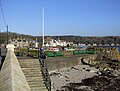
 A view towards the pier, Millport - geograph.org.uk - 1044028.jpg 640 × 428; 50 KB
-
 Admiralty Chart No 2472 Loch Gilp Sketch of Millport East Loch Tarbert, Published 1856.jpg 11,025 × 8,296; 24.45 MB
-
 Admiralty Chart No 2472 Plans on the West Coast of Scotland, Published 1932.jpg 8,316 × 12,110; 32.03 MB
-
 Aquarium in the Robertson Museum and Aquarium at FSC Millport.jpg 2,048 × 1,536; 673 KB
-
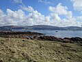
 Arran from Portachur Point - geograph.org.uk - 6302418.jpg 640 × 265; 183 KB
-
 Arran peaks from Fairlie - geograph.org.uk - 2200473.jpg 1,440 × 810; 532 KB
-
 Arran View - geograph.org.uk - 3397817.jpg 640 × 442; 98 KB
-
 B896 near The Lion rock - geograph.org.uk - 5462299.jpg 1,024 × 682; 186 KB
-
 Beach and Millburn Street, Millport - geograph.org.uk - 1041692.jpg 640 × 428; 70 KB
-
 Beach at Millburn Street, Millport - geograph.org.uk - 1041700.jpg 640 × 428; 85 KB
-
 Beach in Millport, Cumbrae, Scotland.jpg 5,390 × 3,593; 10.26 MB
-
 Beach, Millport, Cumbrae, Scotland.jpg 5,428 × 3,075; 9.84 MB
-
 Bessy's Port - geograph.org.uk - 6303280.jpg 640 × 360; 322 KB
-
 Bessy's Port - Isle of Cumbrae - geograph.org.uk - 5614134.jpg 4,222 × 3,103; 2.7 MB
-

-
 Bracken clad east coast of Great Cumbrae - geograph.org.uk - 5462303.jpg 842 × 1,024; 244 KB
-
 Brambles, gorse and a glimpse of Bute and Arran - geograph.org.uk - 4892964.jpg 1,024 × 768; 274 KB
-
 Buoy, Fairlie Roads - geograph.org.uk - 2189479.jpg 640 × 373; 81 KB
-
 Bus to Millport - geograph.org.uk - 2189029.jpg 640 × 368; 73 KB
-
 Calciferous Sandstone - geograph.org.uk - 6303261.jpg 640 × 360; 288 KB
-
 Cleaning the beach, early morning - geograph.org.uk - 2469210.jpg 640 × 480; 83 KB
-
 Cliff above the coast road - geograph.org.uk - 1041496.jpg 640 × 428; 51 KB
-
 Clifton Street, Millport - geograph.org.uk - 4539369.jpg 1,920 × 1,280; 1.52 MB
-
 Coastal rocks near Luckie's Bight - geograph.org.uk - 2999443.jpg 640 × 480; 104 KB
-
 College of the Holy Spirit, Millport - geograph.org.uk - 3669941.jpg 4,320 × 2,430; 1.34 MB
-
 College Street - geograph.org.uk - 5697681.jpg 640 × 470; 149 KB
-
 College Street, Millport - geograph.org.uk - 4539433.jpg 1,920 × 1,280; 1.61 MB
-
 College Street, Millport - geograph.org.uk - 4539508.jpg 1,920 × 1,280; 474 KB
-
 College Street, Millport - geograph.org.uk - 4539555.jpg 1,920 × 1,280; 1.97 MB
-
 College Street, Millport - geograph.org.uk - 4539557.jpg 1,920 × 1,280; 566 KB
-
 Concrete Curling Pond, Millport, Great Cumbrae.JPG 4,033 × 3,218; 6.83 MB
-
 Concrete Curling Pond, the house, Millport, Great Cumbrae.JPG 4,311 × 3,053; 5.37 MB
-
 Consolidated Ash - geograph.org.uk - 6303288.jpg 640 × 427; 475 KB
-
 Contrasting colours and scenery - geograph.org.uk - 1913547.jpg 640 × 480; 102 KB
-

-
 Craigenour Hill - geograph.org.uk - 5698427.jpg 640 × 321; 125 KB
-
 Crawford Mausoleum - Millport - geograph.org.uk - 5351669.jpg 2,930 × 2,185; 1.48 MB
-
 Crawford Mausoleum, Kirkton, Millport, Greart Cumbrae.JPG 3,087 × 3,074; 2.89 MB
-
 Crazy golf and funfair, Millport - geograph.org.uk - 4894302.jpg 1,024 × 768; 164 KB
-
 Crazy golf, Millport seafront - geograph.org.uk - 5697814.jpg 640 × 480; 135 KB
-
 Crazy golf, Millport seafront - geograph.org.uk - 5697967.jpg 640 × 486; 143 KB
-
 Crocodile Rock - geograph.org.uk - 2864682.jpg 1,280 × 856; 154 KB
-
 Crocodile Rock Millport - panoramio.jpg 1,280 × 960; 794 KB
-
 Crocodile Rock, Millport - geograph.org.uk - 2377954.jpg 1,024 × 768; 313 KB
-
 Crocodile Rock, Millport - geograph.org.uk - 4540038.jpg 1,920 × 1,280; 1.43 MB
-
 Crocodile Rock, Millport - geograph.org.uk - 4540040.jpg 1,920 × 1,280; 1.54 MB
-
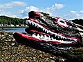 Crocodile Rock, Millport - Isle of Cumbrae - geograph.org.uk - 6136656.jpg 4,017 × 3,013; 2.99 MB
-
 Cross-bedded Sandstone - geograph.org.uk - 6302638.jpg 640 × 360; 346 KB
-
 Cross-bedded Sandstone - geograph.org.uk - 6303263.jpg 640 × 427; 353 KB
-

-
 Curling Bothy detail, Barbay Hill, Great Cumbrae, Scotland.JPG 2,860 × 4,044; 7.24 MB
-
 Desiccation Cracks - geograph.org.uk - 6303298.jpg 640 × 427; 494 KB
-
 Dinantian Dyke - geograph.org.uk - 6303269.jpg 640 × 427; 405 KB
-

-
 Dundonald Villa - Kames Bay, Millport - geograph.org.uk - 5894217.jpg 1,730 × 2,135; 298 KB
-
 Dykes - geograph.org.uk - 6302616.jpg 427 × 640; 389 KB
-
 Eilean na Gourock - geograph.org.uk - 2382694.jpg 1,075 × 806; 313 KB
-
 Fairlie Roads - geograph.org.uk - 4893646.jpg 1,024 × 768; 182 KB
-
 Fairlie View - geograph.org.uk - 3398550.jpg 640 × 467; 94 KB
-
 Farland Bight - geograph.org.uk - 3398512.jpg 640 × 445; 92 KB
-
 Farland Bight - geograph.org.uk - 4893678.jpg 1,024 × 768; 203 KB
-
 Farland Point - geograph.org.uk - 2191433.jpg 640 × 480; 106 KB
-
 Farland Point - geograph.org.uk - 3398492.jpg 640 × 480; 93 KB
-
 Farland Point - geograph.org.uk - 3398505.jpg 640 × 446; 82 KB
-
 Farland Point - geograph.org.uk - 4892646.jpg 1,024 × 768; 206 KB
-
 Farland Point near low tide - geograph.org.uk - 2387414.jpg 1,152 × 864; 305 KB
-
 Farland Point path - geograph.org.uk - 1230101.jpg 640 × 480; 91 KB
-
 Firth Of Clyde , A Spappy Snap - geograph.org.uk - 3765894.jpg 1,600 × 1,200; 208 KB
-
 Firth Of Clyde , Millport Bay - geograph.org.uk - 3765473.jpg 1,600 × 1,200; 168 KB
-
 Firth Of Clyde , Millport Bay - geograph.org.uk - 3765872.jpg 1,600 × 1,200; 230 KB
-
 Firth Of Clyde , Millport Time - geograph.org.uk - 4735536.jpg 1,600 × 1,200; 252 KB
-
 Firth Of Clyde , Newtown Bay, Millport - geograph.org.uk - 3765879.jpg 1,600 × 1,200; 317 KB
-
 Firth Of Clyde , The End Of Millport Pier - geograph.org.uk - 3765630.jpg 1,600 × 1,200; 331 KB
-
 Firth Of Clyde , The Old Pier At Millport - geograph.org.uk - 3765865.jpg 1,600 × 1,200; 257 KB
-

-

-

-
 Firth Of Clyde Architecture , The War Memorial, Millport - geograph.org.uk - 3765845.jpg 1,200 × 1,600; 363 KB
-
 Firth Of Clyde Townscape , Benches At Millport - geograph.org.uk - 3765485.jpg 1,600 × 1,200; 342 KB
-
 Firth Of Clyde Townscape , Cardiff Street, Millport - geograph.org.uk - 4735534.jpg 1,600 × 1,200; 240 KB
-
 Firth Of Clyde Townscape , Crocodile Rock, Millport - geograph.org.uk - 3765889.jpg 1,600 × 1,200; 322 KB
-

-
 Firth Of Clyde Townscape , Main Street, Millport - geograph.org.uk - 3765480.jpg 1,600 × 1,200; 355 KB
-
 Firth Of Clyde Townscape , Millport Delivery Office - geograph.org.uk - 3765650.jpg 1,200 × 1,600; 308 KB
-
 Firth Of Clyde Townscape , Millport Time - geograph.org.uk - 3765490.jpg 1,600 × 1,200; 271 KB
-
 Firth Of Clyde Townscape , Millport's Unsafe Area - geograph.org.uk - 3765622.jpg 1,600 × 1,200; 314 KB
-
 Firth Of Clyde Townscape , Sunshine On Millport - geograph.org.uk - 3765856.jpg 1,600 × 1,200; 415 KB
-
 Fishing boat and gulls - geograph.org.uk - 1913538.jpg 640 × 480; 104 KB
-
 Foreshore north of Fintry Bay - geograph.org.uk - 3001345.jpg 640 × 480; 92 KB
-
 Former paddling pool - geograph.org.uk - 1913516.jpg 640 × 480; 104 KB
-
 Fossil Ripples - geograph.org.uk - 6303590.jpg 427 × 640; 454 KB
-
 Foul Port - geograph.org.uk - 6303272.jpg 640 × 360; 395 KB
-

-
 From Millport Pier - geograph.org.uk - 1142220.jpg 640 × 426; 67 KB
-
 From the pier - geograph.org.uk - 1142230.jpg 640 × 426; 69 KB
-
 Garrison House (Sunken Garden) Millport, Isle of Cumbrae - geograph.org.uk - 6240598.jpg 3,066 × 2,299; 3.36 MB
-
 Garrison Model Railway Club - geograph.org.uk - 3398441.jpg 640 × 441; 94 KB
-
 George Street, Millport - geograph.org.uk - 4539988.jpg 1,920 × 1,280; 1.73 MB
-
 Glasgow Street, Millport - geograph.org.uk - 1044144.jpg 640 × 428; 54 KB
-
 Glasgow Street, Millport - Isle of Cumbrae - geograph.org.uk - 5705280.jpg 4,320 × 3,240; 3.17 MB
-
 Great Cumbrae Shore - geograph.org.uk - 6302603.jpg 640 × 358; 337 KB
-
 Great Cumbrae Shoreline - geograph.org.uk - 5598260.jpg 3,087 × 2,322; 1.02 MB
-
 Gulls at low tide - geograph.org.uk - 1913501.jpg 640 × 481; 104 KB
-
 Harbour, Millport - geograph.org.uk - 553740.jpg 640 × 480; 91 KB
-
 House at the end of Miller Street - geograph.org.uk - 4892662.jpg 1,024 × 768; 128 KB
-
 Houses by the shore at Millport - geograph.org.uk - 3616485.jpg 4,320 × 3,240; 2.06 MB
-
 HUN7 - geograph.org.uk - 2189474.jpg 640 × 441; 91 KB
-
 Hunterston from Millport - geograph.org.uk - 5697963.jpg 640 × 268; 68 KB
-
 Hunterston from Millport - geograph.org.uk - 5697980.jpg 640 × 480; 132 KB
-
 Hunterston Turbines - geograph.org.uk - 5548760.jpg 640 × 409; 63 KB
-
 Hunterston View - geograph.org.uk - 3398517.jpg 640 × 480; 105 KB
-
 Hunterston View - geograph.org.uk - 3398540.jpg 640 × 466; 126 KB
-
 Integrated transport - geograph.org.uk - 1904878.jpg 640 × 480; 120 KB
-
 Intrusive dyke on Cumbrae - geograph.org.uk - 2382603.jpg 1,152 × 864; 315 KB
-
 Italian Sunken Gardens - geograph.org.uk - 1142208.jpg 640 × 426; 77 KB
-
 Jetty and town - geograph.org.uk - 5814620.jpg 640 × 480; 89 KB
-
 Jetty at Millport - geograph.org.uk - 4540068.jpg 1,920 × 1,280; 586 KB
-
 Jougs, Kirkton, Millport, Great Cumbrae.JPG 3,169 × 4,343; 4.68 MB
-
 Just north of Butter Lump - geograph.org.uk - 2387352.jpg 1,152 × 864; 318 KB
-
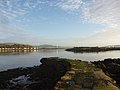
 Kames Bay - geograph.org.uk - 4892656.jpg 1,024 × 655; 163 KB
-
 Kames Bay - geograph.org.uk - 6303213.jpg 640 × 360; 282 KB
-
 Kames Bay at low tide - geograph.org.uk - 1913504.jpg 640 × 489; 105 KB
-
 Kames Bay beach - geograph.org.uk - 2379823.jpg 1,408 × 1,056; 290 KB
-
 Kames Bay Model Yacht Pond - Isle of Cumbrae - geograph.org.uk - 5205649.jpg 4,249 × 3,209; 1.59 MB
-
 Kames Bay View - geograph.org.uk - 3398471.jpg 640 × 435; 84 KB
-
 Kames Bay, Millport - geograph.org.uk - 3398466.jpg 640 × 480; 85 KB
-
 Kames Bay, Millport - geograph.org.uk - 5569692.jpg 1,600 × 1,010; 391 KB
-
-
 Keppel Pier - geograph.org.uk - 2387391.jpg 1,152 × 864; 361 KB
-
 Keppel Pier - geograph.org.uk - 2999434.jpg 640 × 480; 98 KB
-
 Keppel Pier - geograph.org.uk - 5079355.jpg 800 × 574; 117 KB
-
 Keppel Pier - geograph.org.uk - 5569437.jpg 1,600 × 1,032; 274 KB
-
 Keppel Pier - geograph.org.uk - 5569441.jpg 1,600 × 1,067; 260 KB
-
 Keppel Pier - geograph.org.uk - 5569447.jpg 1,600 × 1,067; 323 KB
-
 Keppel Pier, Great Cumbrae - geograph.org.uk - 5204898.jpg 4,320 × 3,240; 1.88 MB
-
 Large pasture - geograph.org.uk - 1230008.jpg 640 × 480; 85 KB
-
 Low tide, looking towards Eilean na Gourock - geograph.org.uk - 2377233.jpg 1,152 × 864; 322 KB
-
 Marina at west end of Millport Bay - geograph.org.uk - 5614590.jpg 1,920 × 1,080; 952 KB
-
 Marine Parade - geograph.org.uk - 5697974.jpg 640 × 379; 149 KB
-
 Marine Parade - geograph.org.uk - 5697976.jpg 640 × 480; 160 KB
-
 Marine Parade, Millport - geograph.org.uk - 1044216.jpg 640 × 428; 49 KB
-
 Marine Parade, Millport - geograph.org.uk - 2864349.jpg 1,280 × 856; 127 KB
-
 Marine Station - geograph.org.uk - 2191449.jpg 640 × 480; 95 KB
-
 Marine station on Great Cumbrae - geograph.org.uk - 1432592.jpg 640 × 384; 54 KB
-
 Mid Kirkton Cemetery, Millport, Great Cumbrae.JPG 4,608 × 3,456; 3.63 MB
-
 Millport - geograph.org.uk - 2189519.jpg 640 × 359; 78 KB
-
 Millport - geograph.org.uk - 2196885.jpg 640 × 480; 74 KB
-
 Millport - Great Cumbrae.jpg 640 × 424; 89 KB
-
 Millport - Isle of Cumbrae - geograph.org.uk - 5387451.jpg 4,232 × 3,211; 1.83 MB
-
 Millport - Scotland.JPG 1,600 × 1,200; 268 KB
-
 Millport - the western side of the town - geograph.org.uk - 2382533.jpg 1,152 × 864; 256 KB
-
 Millport - West Bay - geograph.org.uk - 5278002.jpg 4,217 × 3,216; 1.4 MB
-
 Millport - West Bay - geograph.org.uk - 5388900.jpg 4,320 × 3,240; 1.64 MB
-
 Millport Banner.jpg 3,087 × 441; 434 KB
-
 Millport Bay - geograph.org.uk - 1913523.jpg 640 × 489; 101 KB
-
 Millport Bay - geograph.org.uk - 3397784.jpg 640 × 407; 83 KB
-
 Millport Bay - geograph.org.uk - 4539377.jpg 1,920 × 1,280; 1.23 MB
-
 Millport Bay - geograph.org.uk - 4539422.jpg 1,920 × 1,280; 1.51 MB
-
 Millport Bay - geograph.org.uk - 4540107.jpg 1,868 × 1,208; 213 KB
-
 Millport Bay - geograph.org.uk - 4540108.jpg 1,920 × 1,280; 985 KB
-
 Millport Bay - geograph.org.uk - 5778488.jpg 1,298 × 1,298; 1.33 MB
-
 Millport Bay - geograph.org.uk - 6302443.jpg 640 × 427; 346 KB
-
 Millport Bay and Fairlie Roads - geograph.org.uk - 4894861.jpg 1,024 × 752; 157 KB
-
 Millport beach - geograph.org.uk - 3669919.jpg 4,320 × 2,160; 1.39 MB
-
 Millport Beach - panoramio.jpg 1,280 × 960; 875 KB
-
 Millport Cottage Hospital - geograph.org.uk - 427844.jpg 640 × 434; 97 KB
-
 Millport from Nupkur Point - geograph.org.uk - 5462242.jpg 1,024 × 682; 156 KB
-
 Millport Harbour - geograph.org.uk - 1044078.jpg 640 × 428; 73 KB
-
 Millport harbour at low tide - geograph.org.uk - 1965378.jpg 1,600 × 1,200; 390 KB
-
 Millport Lido - geograph.org.uk - 2382539.jpg 1,152 × 864; 301 KB
-
 Millport Pier - geograph.org.uk - 4012734.jpg 640 × 480; 58 KB
-
 Millport Pier - geograph.org.uk - 822359.jpg 640 × 480; 110 KB
-
 Millport pipes and drums - geograph.org.uk - 3770354.jpg 640 × 480; 86 KB
-
 Millport Police Station - geograph.org.uk - 2382542.jpg 1,408 × 1,056; 345 KB
-
 Millport seafront - geograph.org.uk - 5697966.jpg 640 × 480; 196 KB
-
 Millport seafront - geograph.org.uk - 5698273.jpg 640 × 480; 204 KB
-
 Millport seafront - geograph.org.uk - 5698274.jpg 640 × 480; 216 KB
-
 Millport Seafront at Low Tide - geograph.org.uk - 4540062.jpg 1,920 × 1,280; 588 KB
-
 Millport Town and Bay - geograph.org.uk - 1528079.jpg 640 × 480; 54 KB
-
 Millport War Memorial - geograph.org.uk - 2388327.jpg 960 × 1,280; 276 KB
-
 Millport Waterfront - geograph.org.uk - 5244055.jpg 4,219 × 3,148; 1.66 MB
-
 Millport Waterfront - geograph.org.uk - 5244215.jpg 4,210 × 3,138; 1.49 MB
-
 Millport West Bay - geograph.org.uk - 5778471.jpg 1,280 × 1,280; 1.2 MB
-
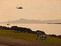 Millport, a helicopter over the bay - geograph.org.uk - 1540144.jpg 640 × 480; 119 KB
-

-
 Millport, a yacht departs - geograph.org.uk - 1539755.jpg 640 × 480; 106 KB
-
 Millport, bench overlooking Kames Bay - geograph.org.uk - 1539917.jpg 640 × 480; 190 KB
-

-
 Millport, Cardiff Street - geograph.org.uk - 1539778.jpg 640 × 480; 158 KB
-
 Millport, Cumbrae, Scotland.jpg 5,472 × 3,382; 8.89 MB
-

-
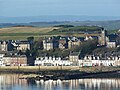
 Millport, Great Cumbrae Island - geograph.org.uk - 1514242.jpg 640 × 450; 61 KB
-
 Millport, Great Cumbrae Island - geograph.org.uk - 1514265.jpg 640 × 368; 44 KB
-
 Millport, Great Cumbrae Island - geograph.org.uk - 1710007.jpg 1,000 × 730; 104 KB
-
 Millport, houses on Kelburn Street - geograph.org.uk - 1539922.jpg 640 × 480; 148 KB
-

-


_Millport,_Isle_of_Cumbrae_-_geograph.org.uk_-_6240598.jpg)


