Category:Midland Bank, Everton Road
Jump to navigation
Jump to search
| Object location | | View all coordinates using: OpenStreetMap |
|---|
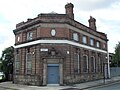
Former Midland Bank at the junction of Low Hill, Everton Road and Brunswick Road, built 1920s to replace an earlier building on Everton Road which dated to 1876. Previously trade union office, as of 2018 is student accommodation.
Media in category "Midland Bank, Everton Road"
The following 6 files are in this category, out of 6 total.
-
 Entrance gates to Grant Gardens.jpg 5,268 × 3,525; 10.03 MB
-

-
 Midland Chambers, July 07, 2012.jpg 3,648 × 2,736; 1.83 MB
-
 The Old Bank, Everton Road 2018-1.jpg 4,824 × 3,531; 9.53 MB
-
 The Old Bank, Everton Road 2018-2.jpg 5,049 × 3,369; 9.55 MB
-
 The Old Bank, Everton Road 2018-3.jpg 4,398 × 3,357; 9.03 MB


