Category:Mid-Kent Line
Jump to navigation
Jump to search
railway line in the UK .JPG)  | |||||
| Upload media | |||||
| Instance of | |||||
|---|---|---|---|---|---|
| Part of |
| ||||
| Location | Greater London, London, England | ||||
| Connects with | |||||
| Owned by | |||||
| Operator | |||||
| Date of official opening |
| ||||
| Terminus | |||||
 | |||||
Subcategories
This category has the following 14 subcategories, out of 14 total.
B
C
- Clock House railway station (24 F)
E
- Eden Park railway station (36 F)
H
L
- Ladywell railway station (34 F)
N
S
- St Johns railway station (53 F)
W
- West Wickham railway station (25 F)
Media in category "Mid-Kent Line"
The following 33 files are in this category, out of 33 total.
-
 Footbridge over the railway at Bellingham - geograph.org.uk - 841070.jpg 640 × 480; 129 KB
-
 Hayes branch - geograph.org.uk - 4147408.jpg 640 × 480; 153 KB
-
 Looking down the tracks to Ladywell station - geograph.org.uk - 2716106.jpg 3,456 × 2,592; 3.13 MB
-
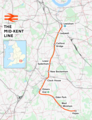 Mid-Kent line.png 2,008 × 2,611; 4.21 MB
-
 Railway bridge near Lower Sydenham - geograph.org.uk - 2315320.jpg 640 × 480; 140 KB
-
 Railway bridge no. 469, Catford - geograph.org.uk - 1633773.jpg 640 × 480; 90 KB
-
 Railway bridge over Stanhope Grove - geograph.org.uk - 2485790.jpg 640 × 480; 135 KB
-
 Railway Bridge, Stanton Way - geograph.org.uk - 3141950.jpg 640 × 430; 99 KB
-
 Railway Bridge, Stanton Way - geograph.org.uk - 3142110.jpg 640 × 430; 72 KB
-

-
-
 Railway line passing alongside Ladywell Fields - geograph.org.uk - 2716060.jpg 3,456 × 2,592; 3.22 MB
-
 Railway line passing alongside Ladywell Fields ^2 - geograph.org.uk - 2716065.jpg 3,456 × 2,592; 2.96 MB
-
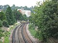
 Railway line south of Lewisham - geograph.org.uk - 3098000.jpg 640 × 430; 72 KB
-
 Railway line to Catford Bridge - geograph.org.uk - 3147440.jpg 640 × 430; 108 KB
-
 Railway line to Catford Bridge - geograph.org.uk - 3168433.jpg 640 × 430; 133 KB
-
 Railway line to Crofton Park - geograph.org.uk - 3181647.jpg 640 × 430; 101 KB
-
 Railway line to Hayes - geograph.org.uk - 2581156.jpg 4,288 × 3,216; 6.85 MB
-
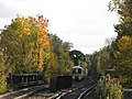
 Railway line to Ladywell - geograph.org.uk - 3168428.jpg 640 × 430; 120 KB
-
 Railway line to Lower Sydenham - geograph.org.uk - 3147441.jpg 640 × 357; 85 KB
-
 Railway line to West Wickham - geograph.org.uk - 2581162.jpg 4,288 × 3,216; 7.53 MB
-

-
 Railway to Clock House - geograph.org.uk - 2652495.jpg 4,288 × 3,216; 7.27 MB
-
 Railway to New Beckenham - geograph.org.uk - 2652483.jpg 3,497 × 2,648; 6.02 MB
-
 Railway tracks north of Bridge Road, BR3 - geograph.org.uk - 2370090.jpg 640 × 480; 129 KB
-
 Railway tracks south of Bridge Road, BR3 - geograph.org.uk - 2370077.jpg 640 × 480; 143 KB
-

-
 Railways cross, Beckenham - geograph.org.uk - 2885599.jpg 1,600 × 1,064; 519 KB
-

-
 The Mid-Kent Line crosses the River Ravensbourne - geograph.org.uk - 2502058.jpg 4,000 × 3,000; 4.14 MB
-
-
 Tracks north of Elmers End station - geograph.org.uk - 2338999.jpg 640 × 480; 123 KB
-
 West Wickham, Railway towards Eden Park - geograph.org.uk - 1928780.jpg 3,456 × 2,304; 6.43 MB


_station_-_geograph.org.uk_-_2442668.jpg)


