Category:Michelhöhle (D 150)
Jump to navigation
Jump to search
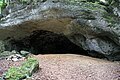
Deutsch: Die Michelhöhle (HFA-Katasternummer: D 150), auch als Appenloch bezeichnet, ist eine Karsthöhle im Landkreis Nürnberger Land in Mittelfranken in Bayern. Sie ist als Geotop (574H016) sowie als Bodendenkmal (D-5-6334-0022: Höhlenstation vor- und frühgeschichtlicher Zeitstellung) ausgewiesen.
cave in Landkreis Nürnberger Land in Bavaria  | |||||
| Upload media | |||||
| Instance of | |||||
|---|---|---|---|---|---|
| Part of | |||||
| Location | Velden, Nürnberger Land, Middle Franconia, Bavaria, Germany | ||||
| Heritage designation |
| ||||
| Width |
| ||||
| Length |
| ||||
| Area |
| ||||
| Elevation above sea level |
| ||||
| official website | |||||
 | |||||
Media in category "Michelhöhle (D 150)"
The following 6 files are in this category, out of 6 total.
-
 Michelhöhle 01.jpg 5,184 × 3,456; 8.68 MB
-
 Michelhöhle 02.jpg 5,184 × 3,456; 9.08 MB
-
 Michelhöhle 03.jpg 5,184 × 3,456; 8.81 MB
-
 Michelhöhle 04.jpg 5,184 × 3,456; 9.7 MB
-
 Michelhöhle 05.jpg 5,184 × 3,456; 8.82 MB
-
 Michelhöhle 06.jpg 5,184 × 3,456; 8.82 MB


